 NERC Data Catalogue Service
NGDC Deposited Data
Type of resources
Topics
Keywords
Contact for the resource
Provided by
Years
Formats
Representation types
Update frequencies
Service types
Scale
Resolution
-

Description of peatland sites included in the compilation of carbon accumulation rates, including resolution (high, low), interpolation (yes/no), contributor name, country, lon, lat, peatland type, dominant plant type, no. of dates used in the last millenium carbon accumulation rate calculation, and problems with the data. Peatland sites at northern hemisphere high and mid latitudes (260), tropical (30) and southern hemisphere high latitudes (7 sites).
-

Rotating Rayleigh-Benard convection. Table of the input and output parameters of the simulations. Snapshot of the temperature field, three components of the velocity and three components of the magnetic field in 3D. Data generated with a magnetohydrodynamical code of rotating Boussinesq convection in planar geometry (Cattaneo et al. 2003 ApJ 588 1183-1198). Data published in Guervilly, Hughes & Jones 2014 JFM 758 407-435 (DOI:10.1017/jfm.2014.542) and Guervilly, Hughes & Jones 2015 PRE 91 041001 (DOI: 10.1103/PhysRevE.91.041001)
-
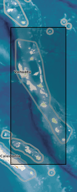
The table contains the list of samples, including location, collected during 2016 field campaign in Vanuatu. Samples include lavas, xenolith (mantle and crustal), scoria, pumice and coral from Esperitu Santo, Efati, Tanna, Ambae, Maewo, Gaua and Vanua Lava. The physical collection is in School of Earth Sciences, University of Bristol.
-

Laboratory experimental data on time-dependent rock deformation by the mechanism of brittle creep. The data was obtained from laboratory triaxial deformation experiments. The full dataset also includes a compilation of data on this topic from other laboratories that has previously been published in the open literature.
-

Output from the FAMOUS General Circulation Model presented in the study by Dentith et al. (2018) "Ocean circulation drifts in multi-millennial climate simulations: the role of salinity corrections and climate feedbacks". The following ocean variables are included at model resolution (2.5 ° x 3.75 °): salinity, meridional overturning streamfunction, potential temperature, mixed layer depth, and barotropic streamfunction. Precipitation, evaporation and sea ice concentration data are also included at atmospheric resolution (5 ° x 7.5 °). All data has been processed into netCDF timeseries.
-
A range of footprint data collected specifically as part of a Natural Environment Research Grant [NE/H004211/1] held jointly between Bournemouth University (Professor Matthew Bennett) and Liverpool University (Professor Robin Crompton). A directory for each of the field sites investigated by the research team, as well as modern data from various laboratory and field simulations. Scans of individual footprints are an ASCII format, each of which contains the X, Y and Z for a digital elevation model. In most cases there is a site map in PDF format providing a key to the prints and file names. In some cases jpeg thumb nails of the scans are also provided. Most directories contain a PDF text file of additional information detailing the equipment used, collection methods, and precision/accuracy of the data, along with any available academic references.
-
Detections of tremor at a set of template locations over the course of four slow slip events in 2004, 2008, 2009, and 2010. As well as identified bursts of tremor within these windows. The dataset consists of: Detected spikes in the tremor time series Each file contains a list of identified spikes in the inter-component coherence time series. LFE (Low frequency earthquakes) locations The locations of LFEs identified by Bostock, M. G., Royer, A. A., Hearn, E. H., and Peacock, S. M. (2012), Low frequency earthquakes below southern Vancouver Island, Geochem. Geophys. Geosyst., 13, Q11007, doi:10.1029/2012GC004391. Cp values through time 12 files containing time series of inter-component and/or inter-station coherence at a range of LFE locations Further descriptions are available in the README and in the preprint hosted on EarthArxiv: Gombert and Hawthorne, Rapid tremor migration during few minute-long slow earthquakes in Cascadia, 2022, doi: 10.31223/X56623.
-
This dataset contains a catalogue of in-situ models for a fault activated by hydraulic fracturing in the Horn River Basin in July 2011. These were created as a part of Kettlety et al. (2019), wherein a Monte Carlo analysis was used to assess fault stability. See attached readme file for more details.
-

Each of this set of 3D X-ray tomography datasets show a particle “bead pack” developed as a magmatic mush analogues but of use to anyone investigating non-spherical systems. The stack of tiff images in each 3D dataset show either cuboid, rod and disc/plate like particles as well as irregular shapes and mixtures of these. The data were used to measure packing geometries, contact areas, and pore volumes, surface areas and connectivity, and perform permeability simulation used to develop advanced porosity-permeability relationships for any bead packing geometry. The data were collected on a Nikon XCT scanner with the exact imaging condition for each scan presented in the txt settings file in each folder (including x-ray energy, flux and resolution information). The data may be of use to those developing advanced finite element, discrete element or flow models in complex packed beds.
-

Radiocarbon ages of planktic and benthic foraminifera from sediment core EW9302-2JPC in the Northwest Atlantic from 0 to 30,000 years ago. Picked monospecific planktic foraminifera (G. bulloides and N. pachyderma) and mixed planospiral benthic formanifera (Cibicidoides, Melonis, Elphidium) were prepared to graphite at the NERC Radiocarbon Facility - East Kilbride and passed to the Keck Carbon Cycle AMS Facility, University of California, Irvine, USA for 14C analysis.