
2021
Type of resources
Available actions
Topics
Keywords
Contact for the resource
Provided by
Years
Formats
Representation types
Update frequencies
status
Service types
Scale
Resolution
-
These data consist of relative telomere length (RTL) measures from quantitative polymerase chain reaction, of Seychelles warbler birds on Cousin Island, Seychelles. The data were collected by the Seychelles Warbler Project in 1995-2014. Data include bird identity, sex, age, birth period, qPCR plate identity, RTL, technician, territory, field period, mum ID, dad ID, mum age at conception, dad age at conception, dominant female ID in the natal territory, dominant male ID in the natal territory Full details about this dataset can be found at https://doi.org/10.5285/8a8240a2-e8ed-495d-ae93-c35200956764
-
[THIS DATASET HAS BEEN WITHDRAWN]. This dataset consists of measures of topsoil (0-15cm) physico-chemical properties from soils sampled from 49 x 1km squares across Great Britain in 2020 as part of a rolling soil and vegetation monitoring program of 500 1km squares repeated every 5 years. The properties included are: soil organic matter (loss on ignition (LOI)), derived carbon concentration, total soil organic carbon (SOC), nitrogen, Olsen-phosphorous, pH, electrical conductivity, soil bulk density of fine earth and fine earth volumetric water content. The UKCEH Countryside Survey is a unique study or 'audit' of the natural resources of the UK's countryside. The sample sites are chosen from a stratified random sample, based on a 15 by 15 km grid of GB. Surveys have been carried out in 1978, 1984, 1990, 1998 and 2007 by the UK Centre for Ecology & Hydrology (UKCEH) and predecessors, with repeated visits to the majority of squares. The countryside is sampled and surveyed using rigorous scientific methods, allowing us to compare new results with those from previous surveys. In this way, we can detect the gradual and subtle changes that occur in the UK's countryside over time. In addition to soil data, vegetation species data are also gathered by the current phase of the Countryside Survey. This work was supported by the Natural Environment Research Council award number NE/R016429/1 as part of the UK-SCAPE programme delivering National Capability. Full details about this dataset can be found at https://doi.org/10.5285/cc2aa8f3-95cb-4b85-b883-8ac26e69bdbe
-
This is a dataset of environmental variables, total invertebrate abundance, and mean invertebrate body mass, sampled at 60 soil habitat patches in the Hengill geothermal valley, Iceland, from May to July 2015. The habitat patches span a temperature gradient of 5 to 22 deg C on average over the sampling period, yet they occur within 2 km of each other and have similar soil moisture, pH, total carbon, and total nitrogen. Full details about this dataset can be found at https://doi.org/10.5285/e00770f3-4acf-4fd5-ba29-0a4dbdca09a4
-

These images were acquired using micro computed tomographic imaging of 7 sandstone plugs taken at various depths in the Sellafield borehole 13B. SF696 (63.8 m), SF697 (76.1 m), SF698 (96.98 m), SF699 (126.27 m), SF700 (144.03 m), SF701 (172.16 m) and SF702 (181.39 m). These samples are further detailed and analysed in the following article: http://dx.doi.org/10.1144/petgeo2020-092
-
The datasets contain maps of the total change in topography along the river Liang (Philippines) after the Typhoon Mangkhut event in September 2018. The maps have been generated using multi-phase mass model r.avaflow to simulate the change in channel and landscape. Full details about this dataset can be found at https://doi.org/10.5285/5d17ff4b-fc98-47e5-9d61-956b17254681
-
This dataset comprises seven ensembles of hydrological model estimates of monthly mean and annual maximum river flows (m3s-1) on a 0.1° × 0.1° grid (approximate grid of 10 km × 10 km) across West Africa for historical (1950 to 2005) and projected future (2006 to 2099) periods. This dataset is the output from the Hydrological Modelling Framework for West Africa, or "HMF-WA" model. The ensembles correspond to historical and three projected future climate scenarios (RCP2.6, RCP4.5 and RCP8.5) with two future scenarios of water use. The scenarios of water use are (i) future water use that varies in line with projected population increases, and (ii) future water use is the same as present day. This dataset is an output from the regional scale hydrological modelling study from African Monsoon Multidisciplinary Analysis-2050 (AMMA-2050) project. Full details about this dataset can be found at https://doi.org/10.5285/6429828f-6a06-4d2d-8f50-4910b18f7ff4
-
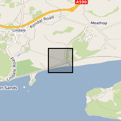
Thermal and Alternating Field demagnetisation data from Visean-carbonates from Meathop Quarry sampled in 2018. This covers the Martin Limestone Formation. MQ are sample codes sampled and data collection carried out by Tereza Kamenikova and Dr Mark Hounslow. The AF demagnetisation data flagged with a *G has a GRM correction applied along the lines described in Stephenson (1993). Data measured on a 2G instruments RAPID, with blank correction as in Hounslow(2019). File for of demagnetisaon data in in header and also described in the GM4Edit software (Hounslow et al. 2019). Sub-samples from main sample given codes like MQ2.1, MQ2.2 etc Hounslow, M.W. 2019. GM4Edit (v.5.6) - a windows program to manage, plot, export and manipulate palaeomagnetic magnetometer datasets. http://dx.doi.org/10.13140/RG.2.2.31877.91361/1.
-
Gridded potential evapotranspiration calculated from United Kingdom Climate Projections 2018 (UKCP18) regional climate model (RCM) ensemble at 12 km resolution over the United Kingdom for the years 1980-2080 under the Representative Concentration Pathway 8.5 (RCP8.5) scenario. This dataset contains two potential evapotranspiration variables: daily total potential evapotranspiration (PET; kg m-2 d-1) and daily total potential evapotranspiration with interception correction (PETI; kg m-2 d-1). PET and PETI were calculated for each member of the UKCP18 RCM perturbed parameter ensemble. The units kg m-2 d-1 are equivalent to mm d-1. The data are provided in gridded netCDF files. There is one file for each variable, for each ensemble member, for each decade. Full details about this dataset can be found at https://doi.org/10.5285/eb5d9dc4-13bb-44c7-9bf8-c5980fcf52a4
-
4 tables, and accompanying references, from paper entitled ‘Increased biomass and carbon burial 2 billion years ago triggered mountain building’. Tables record orogen depositional ages, deformation ages, Total Organic Carbon contents and organic carbon isotope compositions, for 20 orogens of Palaeoproterozoic age.
-

Carbon and oxygen isotopic composition of planktic foraminifera spanning the early and middle Eocene succession recovered from borehole 16/28-Sb01. For description of this sedimentary sequence see Haughton et al. 2005. Petroleum Geology: North-West Europe and Global Perspectives, Proceedings of the 6th Petroleum Geology Conference, 1077–1094.