
Volcanoes
Type of resources
Available actions
Topics
Keywords
Contact for the resource
Provided by
Years
Formats
Representation types
Update frequencies
-
Data output from the numerical flow modelling in GRL manuscript ""Evidence for the top-down control of lava domes on magma ascent dynamics"", by Marsden, L., Neuberg, J. & Thomas, M., all of University of Leeds. The models were created using the Laminar Flow module in COMSOL Multiphysics v5.4 by L. Marsden. The following files are uploaded: Archive_Reference_Model.txt (Reference flow model: Gas loss function, Initial H2O content = 4.5 wt.% Excess pressure at depth = 10 MPa, Constant corresponding to crystal growth rate = 4e-6 s^-1 ) Archive_High_H2O.txt (Gas loss function, Initial H2O content = 10 wt.% Excess pressure at depth = 10 MPa, Constant corresponding to crystal growth rate = 4e-6 s^-1) Archive_No_Gas_Loss.txt (No gas loss, Initial H2O content = 4.5 wt.% Excess pressure at depth = 10 MPa, Constant corresponding to crystal growth rate = 4e-6 s^-1) Archive_Gamma_Low.txt (Gas loss function, Initial H2O content = 4.5 wt.% Excess pressure at depth = 10 MPa, Constant corresponding to crystal growth rate = 1e-6 s^-1) Archive_Excess_Pressure_0MPa.txt (Gas loss function, Initial H2O content = 4.5 wt.% Excess pressure at depth = 0 MPa, Constant corresponding to crystal growth rate = 4e-6 s^-1) Archive_Excess_Pressure_20MPa.txt (Gas loss function, Initial H2O content = 4.5 wt.% Excess pressure at depth = 20 MPa, Constant corresponding to crystal growth rate = 4e-6 s^-1) The files uploaded include the reference flow model and where a single key parameter has been changed in the flow modelling. We include data where the key parameter is at the upper or lower limit of the values tested. Data are not included where magma ascent is modelled to stall without the extrusion of a lava dome, as a time dependent model is not run in this case. A solution is provided using equilibrium modelling only. The following variables are output, at conduit centre unless specified: Depth (m), Time(s), Ascent velocity (m/s), Bulk Viscosity (Pa s), Crystal Content, Dome height (m), Gas Volume Fraction, Overpressure (Pa), Shear Stress at Conduit Wall (Pa)
-
Laser ablation (LA) ICP-MS analyses (presented in parts per million, ppm) of melt inclusions from the 1980 eruption of Mt. St. Helens (18th May-16th October). Detailed sample collection methods are given in Blundy et al. (2008). Blundy, J., Cashman, K.V. and Berlo, K. (2008) Evolving magma storage conditions beneath Mount St. Helens inferred from chemical variations in melt inclusions from the 1980-1986 and current (2004-2006) eruptions, in: Sherrod, D.R., Scott, W.E., Stauffer, P.H. (Eds.), A volcano rekindled: the renewed eruption of Mount St. Helens, 2004-2006, Reston, VA, pp. 755-790.
-
This data set characterises the seismicity occurring within 30 km of the Bora - Tullu-Moye volcanic field between 2016 and 2017. It also provides a description of key geologic features in this region. See the README file for a full explanation of the data set. These data were originally published as supplementary material in g-cubed article: Seismicity of the Bora – Tullu-Moye Volcanic field 2016-2017: Greenfield et al (2018), https://doi.org/10.1029/2018GC007648
-

Acoustic emissions (AE) and ultrasonic wave velocity data recorded during a series of high temperature thermal cracking experiments by Daoud et al., in the Rock and Ice Physics Laboratory of the University College London. The data gives the time and magnitude of AE output which were recorded contemporaneously whilst cyclically heating three rock types (A Slaufrudalur Granophyre, A Santorini Andesite and a Seljadalur Basalt). The ultrasonic wave velocity data was recorded pre- and post- heating. The data acquisition was permitted using a rock placed within an acoustic wave guide placed inside a high temperature furnace.
-
Microgravity data collected at Uturuncu Volcano between March 2010 and November 2018 The file contains microgravity data collected between March 2010 and November 2018 in the Altiplano-Puna Volcanic complex.
-

Surface level measurements of the Erebus volcano lava lake, Antarctica. Surface level was measured from a site at the crater rim using the Eredar radar system, a ground-based X-band FMCW radar (described in detail here: https://doi.org/10.1029/2018GL079177). The dataset contains a single continuous measurement period from 2016 (all times in UTC): 19 Dec 00:35 -> 19 Dec 19:21 Measurements were taken at a rate of ~0.25 Hz, using a 0.16 s 400 MHz bandwidth Linear Frequency Modulated chirp centred at 10.4 GHz, with 10 chirps being averaged for each measurement.
-

Surface level measurements of the Halema'uma'u lava lake, Hawaii. Surface level was measured from a site at the crater rim (19.40452 N 155.27944 W 1125 M a.s.l) using the Eredar radar system, a ground-based X-band FMCW radar (described in detail here: https://doi.org/10.1029/2018GL079177). Due to technical problems, the radar did not acquire continuously throughout its deployment. The dataset contains three blocks of successful continuous measurement periods (all times in UTC): 10 Jan 22:18 -> 11 Jan 08:46 11 Jan 21:24 -> 12 Jan 22:49 14 Jan 20:27 -> 14 Jan 23:01 Measurements were taken at a rate of ~1 Hz, using a 20 ms 400 MHz bandwidth Linear Frequency Modulated chirp centred at 10.25 GHz.
-
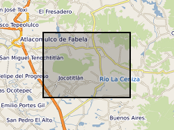
The data is provided as a single spreadsheet containing geochemical information from three volcanoes (Antuco, Chile; Jocotitlan, Mexico; Montserrat), all of which have been affected by major debris avalanches. The data was collected in order to investigate the long-term evolution of these volcanic systems. In addition, a single worksheet is provided of a summary database of published examples of volcanic debris avalanches. The geochemical data include bulk-rock XRF and ICP-MS data, Sr and Pb isotope measurements, and glass analyses for the Montserrat samples, along with site information for Antuco and Jocotitlan. Additional published analyses for Montserrat is availabile in published papers, as detailed in the spreadsheet.
-

Whole rock analyses (presented in parts per million, ppm) of volcanic samples from Mt. St Helens, Washington, USA. Detailed sample descriptions and given in Blundy et al. (2008) and references therein. All samples were analysed using solution ICP-MS at the Open University. Blundy, J., Cashman, K.V. and Berlo, K. (2008) Evolving magma storage conditions beneath Mount St. Helens inferred from chemical variations in melt inclusions from the 1980-1986 and current (2004-2006) eruptions, in: Sherrod, D.R., Scott, W.E., Stauffer, P.H. (Eds.), A volcano rekindled: the renewed eruption of Mount St. Helens, 2004-2006, Reston, VA, pp. 755-790.
-

Global dataset of active volcanoes along with active and potential geothermal sites. The dataset provides geographic coordinates of; 1) active volcanoes that have erupted in the last 10,000 years worldwide for use by Volcanic Ash Advisory Centers (VAAC) as compiled by the Smisthonian Institution (https://volcano.si.edu/projects/vaac-data/) ; 2) Geographic coordinates of active geothermal sites; 3) Geographic coordinates of potential geothermal sites. Both 2) and 3) were compiled by Coro and Trumpy, 2020 (https://doi.org/10.1016/j.jclepro.2020.121874). These data are compiled together in a map in the publication Lavallée et al., 2025 (https://doi.org/10.1017/s1062798724000292). The data compiled here are global datasets and the map was created at LMU Munich. The open-source data from Smisthonian Institution is collected and updated since 2013. All data used by Lavallée et al., 2025 were sourced and compiled in January 2024.The compilation was done using Matlab and a basemap provided by ESRI in 2009 The data were used to show how the potential and safe use of magma energy by geothermal power plants at recently active volcanoes could help with the energy transition.