 NERC Data Catalogue Service
MS Excel
Type of resources
Available actions
Topics
Keywords
Contact for the resource
Provided by
Years
Formats
Representation types
Update frequencies
Scale
-
Gro for GooD VES (Vertical Electrical Soundings) Data, Kwale County, Kenya (NERC grant NE/M008894/1)
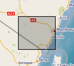
Results of Vertical Electrical Soundings (VES) study conducted in Kwale County, Kenya in July and August 2017 by University of Nairobi and Water Resources Management Authority as part of the Gro for GooD project (https://upgro.org/consortium/gro-for-good/) to determine the existence of deeper aquifers.
-
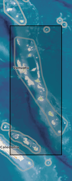
The table contains the list of samples, including location, collected during 2016 field campaign in Vanuatu. Samples include lavas, xenolith (mantle and crustal), scoria, pumice and coral from Esperitu Santo, Efati, Tanna, Ambae, Maewo, Gaua and Vanua Lava. The physical collection is in School of Earth Sciences, University of Bristol.
-
This dataset was acquired as part of a NERC-funded Doctoral Training Partnership (DTP) PhD Studentship at the University of Leicester and British Geological Survey between 2014-2018 [grant no. NE/L002493/1] (see also Emmings, 2018 unpublished PhD thesis). This research was conducted within the Central England NERC Training Alliance (CENTA) consortium. This dataset accompanies a manuscript titled "Late Palaeozoic Phytoplankton Blackout: A 100 Myr Record of Enhanced Primary Productivity". Co-authors and co-workers were: Joseph F. Emmings (University of Leicester, British Geological Survey); Sarah J. Davies (University of Leicester); Simon W. Poulton (University of Leeds); Michael H. Stephenson (British Geological Survey); Gawen R. T. Jenkin (University of Leicester); Christopher H. Vane (British Geological Survey); Melanie J. Leng (British Geological Survey, University of Nottingham) and Vicky Moss-Hayes (British Geological Survey). Nick Riley (Carboniferous Ltd) is thanked for sharing biostratigraphic expertise and assistance. Nick Marsh and Tom Knott are thanked for providing assistance during geochemical analyses. This dataset contains the following data (in Microsoft Excel format). 1) Fe species abundance data measured at the University of Leeds using the sequential extraction method of Poulton and Canfield (2005) and pyrite S extraction method of Canfield et al., (1986); 2) Total Fe, Si, Mn and Al major element concentrations (measured using x-ray fluorescence at the University of Leicester; XRF); 3) Total organic carbon (TOC) and inorganic C (MINC) data measured via Rock-Eval pyrolysis at the British Geological Survey; 4) Cu, Mo and U trace element concentration data (measured via XRF at the University of Leicester) and enrichment factors relative to Post-Archaean Average Shale (PAAS; Taylor and McLennan, 1985). Analyses were coupled on 99 sample powders from three positions in the Craven Basin and spanning ammonoid biozones P2c-d to E1c1. See also http://dx.doi.org/10.5285/9ceadcad-a93c-4bab-8ca1-07b0de2c5ed0 for additional sedimentological and geochemical data from Hind Clough, MHD4 and Cominco S9. These data were also interpreted together with 20 drill-core samples previously acquired from Hind Clough (‘HC01’ prefix). See http://dx.doi.org/10.5285/c39a32b2-1a30-4426-8389-2fae21ec60ad for further information regarding this drill-core dataset. References: Emmings, J. 2018. Controls on UK Lower Namurian Shale Gas Prospectivity: Understanding the Spatial and Temporal Distribution of Organic Matter in Siliciclastic Mudstones. Unpublished PhD Thesis. University of Leicester. Poulton, S. W. & Canfield, D. E. 2005. Development of a sequential extraction procedure for iron: implications for iron partitioning in continentally derived particulates. Chemical Geology 214, 209-221, doi:http://dx.doi.org/10.1016/j.chemgeo.2004.09.003. Canfield D., Raiswell R., Westrich J., Reaves CM, Berner RA. 1986. The use of chromium reduction in the analysis of reduced inorganic sulfur in sediments and shales. Chemical Geology, 54(1): 149-155. Taylor S, McLennan S. 1985. The Continental Crust: Its Composition and Evolution. Blackwell Scientific: London.
-

Global warming during the Palaeocene-Eocene Thermal Maximum (PETM, ~56 Ma) is commonly interpreted as being driven by massive destabilization of carbon from surficial sedimentary reservoirs. If correct, this has important implications for the amplification of future fossil fuel emissions via carbon-climate feedbacks. In our study we provided new paired records of boron and carbon isotope changes in the ocean that questions this long-held interpretation. Our data are implemented in an Earth system model to reconstruct the unfolding carbon cycle dynamics across the event. Strong evidence for a larger (>10,000 PgC) and on average isotopically heavier (> -17‰) carbon source leads us to identify volcanism associated with the North Atlantic Igneous Province as the main driver of the PETM. We also find that although organic carbon feedbacks with climate played a more minor role in driving the event than previously thought, organic matter burial was important in ultimately sequestering this carbon and driving the recovery of the system. Data presented in this data set comprise geochemical elemental, as well as boron, carbon and oxygen isotopic data from surface dwelling foraminifera Morozovella Subbotina. Alongside the boron isotopic data we also provide reconstructed surface water pH with corresponding uncertainties for our preferred pH reconstruction.
-

The data are associated with a paper entitled 'Widespread tephra dispersal and ignimbrite emplacement from a subglacial volcano (Torfajökull, Iceland)' by J Moles et al. (2019). See paper for full details. Data types: major element geochemistry; trace element geochemistry; 40Ar/39Ar geochronology. Table DR9 contains EPMA data of proximal lavas and ignimbrite fiamme. Table DR10 contains EPMA data of ash shards. Table DR11 contains EPMA standard data. Table DR12 contains LA-ICP-MS data of proximal lavas and ignimbrite fiamme. Table DR13 contains LA-ICP-MS data of ash shards. Table DR14 contains LA-ICP-MS standard data (raw). Table DR15 contains LA-ICP-MS standard data (corrected). Table DR16 contains 40Ar/39Ar geochronology data.
-

The dataset contains details of field collection of groundwater samples with use of different water intake devices and the measurement results of gaseous compounds (methane) obtained during analytical method validation performed in order to develop a methodology of groundwater sampling for analysis of dissolved gases. The dataset is not intended to be used for any site characterisation. Sampling sites were chosen based on high probability of occurrence of measureable methane content in groundwater. Furthermore, the data will be used for formal procedure to obtain the methodology accreditation from the Polish Centre for Accreditation (PCA). The dataset was created within SECURe project (Subsurface Evaluation of CCS and Unconventional Risks) - https://www.securegeoenergy.eu/. This project has received funding from the European Union’s Horizon 2020 research and innovation programme under grant agreement No 764531
-
Vanadium and Zinc isotopic compositions of powdered basalt samples from the active volcanic zones of Iceland. These samples have been extensively characterised for other geochemical quantities in a series of papers (Marshall et al, 2022, Barry et al., 2014; Caracciolo, 2021; Caracciolo et al., 2020; Füri et al., 2010; Halldórsson et al., 2016a, 2016b; Macpherson et al., 2005; Rasmussen et al., 2020).
-
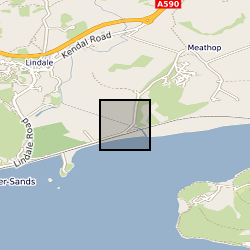
Thermal and Alternating Field demagnetisation data from Visean-carbonates from Meathop Quarry sampled in 2018. This covers the Martin Limestone Formation. MQ are sample codes sampled and data collection carried out by Tereza Kamenikova and Dr Mark Hounslow. The AF demagnetisation data flagged with a *G has a GRM correction applied along the lines described in Stephenson (1993). Data measured on a 2G instruments RAPID, with blank correction as in Hounslow(2019). File for of demagnetisaon data in in header and also described in the GM4Edit software (Hounslow et al. 2019). Sub-samples from main sample given codes like MQ2.1, MQ2.2 etc Hounslow, M.W. 2019. GM4Edit (v.5.6) - a windows program to manage, plot, export and manipulate palaeomagnetic magnetometer datasets. http://dx.doi.org/10.13140/RG.2.2.31877.91361/1.
-

Terrestrial palaeo-environmental proxy data has been collected to examine orbital changes in wildfire activity in the Early Jurassic of the Mochras Borehole, Cardigan Bay Basin, Wales. To do this a high resolution charcoal abundance dataset was created and quantified in two size fractions, microscopic charcoal (10-125 µ) and macroscopic charcoal (>125 µ). To take potential changes in riverine influx and/or organic preservation in account on the charcoal abundance, palynofacies were analysed to document all terrestrial and marine organic particles present in the samples, and next to this, X-ray fluorescence data was gathered to assess detrital output. Mass spectrometry provided information on the carbonate and Total Organic Carbon content and bulk organic carbon isotopes. This information was used to look at changes in the lithology and the carbon cycle. Finally, clay mineralogical data was obtained to look at changes in the hydrological cycle in relation to wildfire activity. This dataset spans 951-934 mbs from the Mochras borehole, which is the time equivalent of ~350 kyr, in the Margaritatus Zone of the Upper Pliensbachian. The Mochras sediments have been deposited in the Cardigan Bay Basin, Wales. At the time of deposition, this location was positioned in the Laurasian Seaway at a paleolatitude of ~35°N. These datasets were obtained at a high resolution (10 cm) using X-ray diffraction, X-ray fluorescence, mass spectrometry and palynological preparations. This high resolution was acquired to analyse the presence of precessional orbital forcing on wildfire and the other proxy datasets. This data was collected, interpreted and analysed by Teuntje Hollaar, Claire Belcher, Stephen Hesselbo, Micha Ruhl, Jean-Franҫois Deconinck, Sarah Jane Baker and Luke Mander. The complete dataset presented in the published article file ‘Wildfire activity enhanced during phases of maximum orbital eccentricity and precessional forcing in the Early Jurassic’ has been included in this data file.
-
This dataset is an additional sample list, as an Excel spreadsheet, providing details of the major sample suites collected by Delia Cangelosi during SoS RARE and not added to the master spreadsheet (https://webapps.bgs.ac.uk/services/ngdc/accessions/index.html#item165705) It includes location details and descriptions for rock samples collected in China and Namibia. Most material is still held by the institutions that did the work, as recorded in the sample list.