
Mineralogy
Type of resources
Available actions
Topics
Keywords
Contact for the resource
Provided by
Years
Formats
Representation types
Update frequencies
Scale
-
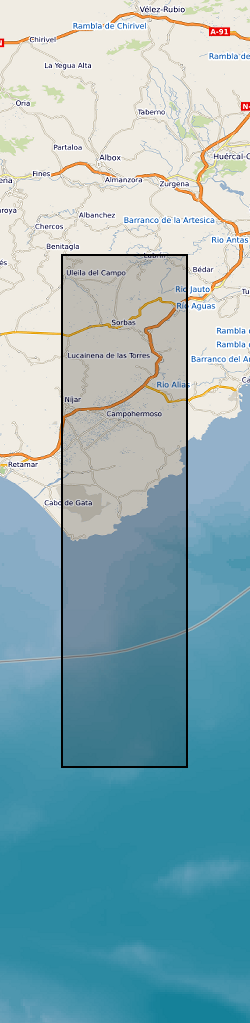
The dataset comprises: Petrophysical data for rocks from the region, XRD mineralogical data, Results of the gravity survey of the basin, tabulation and location of all bedding orientation data for the basin, and sediment transport lineation data. The dataset accompanies publication : On the Structure and Evolution of the Sorbas Basin, S.E. Spain, Tectonophysics 773 (2019) 228230, DOI: https://doi.org/10.1016/j.tecto.2019.228230
-
Oju/Obi is a remote part of Eastern Nigeria. There are severe water shortages during the 4-5 month dry season. The hydrogeology of the area is complex, and groundwater is difficult to find. In an attempt to understand and quantify the available groundwater resources within the area, DFID commissioned BGS from 1997 – 2000 to carry out a hydrogeological review of the area and devise appropriate and effective methods for siting wells and boreholes assessing groundwater resources and how best these resources could be developed. The field study involved the collection of time series data including groundwater chemistry and rainfall Cl along with mineralogical information. These results are being used by WaterAid, Local and regional Government to help local communities develop sustainable water supplies.
-

EPMA (Electron probe microanalysis) major element analyses of clinopyroxene, olivine, amphibole and glass from lava and tephra samples of the 2021 Tajogaite eruption. LAICPMS (Laser Ablation Inductively Coupled Plasma Mass Spectrometry) trace element analyses of selected clinopyroxene from the eruption sequence.
-
Sample locations and geochemical data from the Aurora Ni-Cu-PGE magmatic sulphide deposit, Northern Bushveld Complex, South Africa. Samples were taken from two boreholes on the La Pucella farm, courtesy of Pan Palladium Limited. This data contains petrological photographs; scanning electron microscope element maps and identification of platinum group minerals and precious metal minerals; and trace element concentration of ore minerals. This data was collected as part of the TeaSe consortium NERC grant in order to determine the concentration and hosting of critical and precious metals in various types of ore deposits and barren rocks from different geological environments. This data was collected and interpreted by researchers at Cardiff University and is used in a paper, available at https://doi.org/10.1016/j.oregeorev.2019.02.008.
-

The main aim of the project is to determine the shrinkage and swelling properties of UK clays and mudrocks and to investigate the relationships between them. Thus leading to a better understanding of the shrink/swell behaviour for the user community. Dataset contains geotechnical, physical, mineralogical and geochemical data.
-
Summary of semi-quantitative whole-rock XRD analysis of hydrothermal alteration across the island of Milos, Greece. The samples were acquired during numerous field visits between 2010 and 2018 by the British Geological Survey and GW4+ Doctorial Training Partnership (NE/L002434/1). The data were acquired using a PANAlytical X’Pert Pro diffractometer at the British Geological Survey, Keyworth, UK. These data were primarily used to identify mineral phases to improve our understanding of regional and local paleo-hydrothermal activity. This may be useful within the metallic and industrial mineral mining sector and associated researchers. The data includes grid references (± 5 m), field observations and instrument running conditions. Samples from 2010 are supported by a grant award from the Natural Environment Research Council (GA/09F/139). Samples from 2016 - 2018 are supported by the GW4+ Doctoral Training Partnership (NE/L002434/1) grant award GA/09F/139 – RMS E3557, and the British Geological Survey’s University Funding Initiative (BUFI S345).
-

Index to the reports of work carried out by the BGS and its precursors. The index was set up in 1988 and has worldwide coverage. These reports cover a wide range of scientific and technical disciplines and were produced for a variety of purposes. The reports are not published but copies can be provided on demand subject to any restrictions. All registered Technical Reports held in collection are indexed. Start date of digital index circa 1988. Technical reports date from circa 1950 onwards.
-

A collection of small-scale non-series maps which offer whole-country coverage of the United Kingdom 1856-2013. Included in the collection are geological, tectonic, structural, mineral resource and geophysical maps, together with a small number of historical facsimile maps. Key geological maps included in the collection which ran to many editions are Geology of the British Islands 1:584 000 and the Geological Map of Great Britain 1:625 000. These maps are hard-copy paper records stored in the National Geoscience Data Centre (NGDC) and are delivered as digital scans through the BGS website.
-

Reports of work carried out worldwide by the BGS and its precursors. These reports cover a wide range of scientific and technical disciplines and were produced for a variety of purposes. Reports date from about 1950 although there are only a comparatively small number of reports pre 1960. The reports are not published but copies can be provided on demand, in hard copy or pdf format ,subject to any restrictions.
-

Stress-Dependent permeability data for samples of the Glasgow Main coal and the overlying mudstone and sandstone from the UKGEOS research borehole GGC01. Associated XRD mineralogy, Helium Porosity, bulk and matrix densities are also included. Samples and data are derived from the UK Geoenergy Observatories Programme funded by the UKRI Natural Environment Research Council and delivered by the British Geological Survey.