 NERC Data Catalogue Service
Aberystwyth University
Type of resources
Topics
Keywords
Contact for the resource
Provided by
Years
Formats
Representation types
Update frequencies
Resolution
-
The dataset provides raster gridded estimates of open water and inundated vegetation for the Barotseland Region in Western Zambia. There are a total of 55 images covering the period 2016-2019 at a spatial resolution of 10m. The images were generated using an automatic classification routine applied to Sentinel-1 radar imagery, with classification refinements made using ancillary datasets such as the Global Urban Footprint, and the Height Above Nearest Drainage terrain derivative generated using SRTM digital elevation data. These data are valuable for a range of applications including public health and water resources. Full details about this dataset can be found at https://doi.org/10.5285/4ef558d2-05d4-4ae2-988e-a5c2450b95dd
-

2014 and 2016 time series of automatic weather station (AWS) data (Dataset 1) and (ii) GPS data (Dataset 2) at the location of the SAFIRE research project, Store Glacier, Greenland.
-

2014 and 2016 time series of basal multiprobe data (Dataset 1), englacial temperature data (Dataset 2), and englacial tilt data (Dataset 3) measured in boreholes drilled at the location of the SAFIRE research project, Store Glacier, Greenland.
-
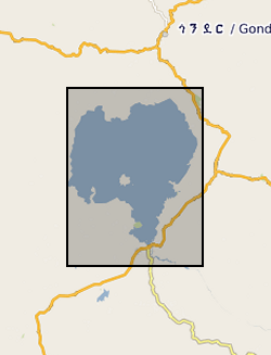
Zr/Rb, Ca/Ti, Rb/K ratios against depth (0.112 m to 62.686 m) and age ( 366 to 150190 yrs). NERC grant, NE/D012996/1, abstract Lake Tana, in the highlands of northern Ethiopia, is the source of the Blue Nile, one of the world's great rivers. Surprisingly, very little is known about the age and history of this lake: one estimate from the 1930's is that it was formed 10,000 years ago by a lava dam. Similarly, little is known about the climatic history of the wider region that comprises the Blue Nile headwaters, despite the fact that the Nile has long been recognized as critical to the resources of ancient and modern Egypt. New geophysical and core data, obtained by us in October 2003 and September 2004 with NERC support, show that the lake may be at least 40,000 years old. Our new data also show that the lake dried out at around 16,000 years ago, and almost certainly at apparently regular intervals during the later stages of the last Ice Age. It is possible that the lake dried because of intense droughts lasting one or two hundred years, and that the droughts were caused by disruption of Africa's monsoon climate when iceberg-laden meltwater from North America flooded the North Atlantic - the Heinrich events. In this new PalaeoTana Project, we aim to test these hypotheses by drilling a sediment core, up to 100m in length, from the northern basin of Lake Tana, in about 10m water depth, and about 2km from shore. The core will be scanned at high resolution using X-ray fluorescence, X-ray and colour imagery, geophysical and magnetic core-scanning technology, without damaging the sedimentary components. The resulting datasets will identify past desiccation events, which will be investigated in detail and interpreted by comparison to sediments of the known drying-out event at 16,000 years ago. Dating the sediments by appropriate methods including luminescence, tephrochronology, and Argon-Argon dating will allow precise estimates of the timing and duration of the drought events. The relative timing of these events in comparison with abrupt climatic events in ocean cores (especially Heinrich events), and in other continental records, will allow inferences about the global- scale mechanisms of abrupt climate change. The data can also be used to test climate models, and thus to help judge the accuracy of model-predicted abrupt climate change in the future. A long core record of past climate and environment from this part of Africa would have major significance for understanding both regional environmental change, because of the influence of the Nile on NE Africa and the eastern Mediterranean, and global climate. It will contribute to understanding how future changes in ocean temperature and circulation will affect global climate, especially in the heavily populated monsoon regions of Africa and Asia. It will also have significance for understanding the later stages of human evolution in and dispersal out of Africa, by providing a record of the environmental changes that influenced early human populations and their water, plant and hunting resources.
-
The dataset contains abundance data of airborne pollen (including Anthoxanthum odoratum (sweet vernal-grass), Arrhenatherum elatius (false oat-grass), Cynosurus cristatus (crested dog's-tail), Dactylis glomerata (cock's-foot), Lolium perenne (perennial ryegrass), Phleum pratense (Timothy), Poa pratensis (smooth meadow-grass), grass species within the genera Alopecurus/Agrostis, and one probe that was found to be degenerate and unable to discriminate grass species. Here we used qPCR to track the seasonal progression of airborne grass pollen, in time and space. To do this we collected aerial samples from thirteen sites across the UK during the pollen seasons (May to September) of 2016 and 2017. Full details about this dataset can be found at https://doi.org/10.5285/28208be4-0163-45e6-912c-2db205126925