 NERC Data Catalogue Service
Biomarkers
Type of resources
Available actions
Topics
Keywords
Contact for the resource
Provided by
Years
Formats
Representation types
Update frequencies
Resolution
-
Spreadsheet containing three tabs of biomarker concentration data for three Mediterranean sapropel records. Core LC21 was collected at 1522m water depth in the Aegean Sea by the R/V Marion Dufresne. An S5 sapropel (core 64PE406-E1) at a water depth of 1760m in the eastern basin aboard the R/V Pelagia. Site 967 of ODP Leg 160 was located at a water depth of 2560 m, south of Cyprus on the lower northern slope of Eratosthenes Seamount, in the eastern Levantine Basin Three core records were extracted for lipid biomarkers and analysed using HPLC and UHPLC-MS. The data and the interpretation of it is available in the published paper; Rush et al., 2019 https://bg.copernicus.org/articles/16/2467/2019/
-
This dataset contains information about the compound-specific stable hydrogen isotope composition (δ2H) of n-alkanoic acids with 26, 28 and 30 carbon atoms. The samples originated from the Lake Suigetsu sediment cores. Data is provided at an approximately ~60 year resolution from 132.7 ka BP to 125.2 ka BP (n = 60). To accompany this data, the mass-normalised concentrations of key n-alkane and n-alkanoic acids are provided, alongside n-alkane index values. This data was collected to infer changes to the Lake Suigetsu catchment and the East Asian Summer Monsoon during Glacial Termination II. This work was supported by the Quaternary Research Association, the Scottish Alliance for Geoscience, Environment and Society, the School of Geographical and Earth Science (University of Glasgow) and the NERC IAPETUS2 Doctoral Training Partnership. Full details about this dataset can be found at https://doi.org/10.5285/e3ebeca1-ce57-40f9-8237-85d8aa543ff8
-
These data consist of relative telomere length (RTL) measures from quantitative polymerase chain reaction, of Seychelles warbler birds on Cousin Island, Seychelles. The data were collected by the Seychelles Warbler Project in 1995-2014. Data include bird identity, sex, age, birth period, qPCR plate identity, RTL, technician, territory, field period, mum ID, dad ID, mum age at conception, dad age at conception, dominant female ID in the natal territory, dominant male ID in the natal territory Full details about this dataset can be found at https://doi.org/10.5285/8a8240a2-e8ed-495d-ae93-c35200956764
-

Organic and inorganic data extracted from core material spanning over a large area of the Baltic basin (Kostovo-13, Grotlingbo-1, File Haidar-1, Boda Hamn-1, Hamnudden-1, Finngrundet-1, Barstad-2 and Bernstorp-1). Organic data include concentrations in pristane, phytane, phenanthrene, methylphenanthrene and arylisoprenoids. Inorganic data include iron speciation data, concentrations in Fe, Al, P, U, Mo, V, total organic C, and C isotope ratios.
-

to provide reliable molecular fingerprints for biodegraded crude oils and contaminated sediment cores and to facilitate correlation studies The aim is to demonstrate the potential of hydropyrolysis (pyrolysis assisted by high hydrogen gas pressure) as a novel means to provide reliable molecular fingerprints for biodegraded oils and contaminated cores where conventional biomarker approaches fail. This will then facilitate accurate and rapid oil-source and oil-oil correlations to be determined for the first time in these situations. New experimental protocols for conducting hydropyrolysis on asphaltenes will be developed. The study will establish a firm base to exploit the commercial potential of hydropyrolysis, both in oil exploration and for characterising sedimentary organic matter as a far superior technique to pyrolysis-GC-MS through a larger industrial partner.
-

The aim is to realise the potential of hydropyrolysis (pyrolysis assisted by high hydrogen gas pressures) as a means to provide reliable molecular fingerprints for severely biodegraded oils, contaminated cores, oil-field solids (tar mats and pyrobitumens) and to provide novel information on basin-filling history where the conventional free-biomarker approach fails. This will then facilitate rapid and accurate oil-source and oil-oil correlations to be determined for the first time in ocean-margin regions. The study will establish a firm base to exploit the commercial potential of hydropyrolysis, both in terms of oil exploration through the new correlations with bound biomarker profiles and of characteristic sedimentary organic matter as a far superior technique to py-GC-MS. Indeed, innovative experimental protocols for conducting hydropyrolysis will continue to be developed to have a prototype system ready for future exploitation.
-

"Three spreadsheet tables of biomarker data, element ratios, and accumulation rates. Sediment samples from IODP Expedition 341, Site U1419 in the Gulf of Alaska. Site U1419 is located in 721 m water depth on the continental slope above the Khitrov basin. Extracted lipids were analysed by HPLC-MS. Two independent methods for bulk element geochemistry analyses were applied to the samples. More details available in the paper Zindorf et al., 2020 https://doi.org/10.1016/j.chemgeo.2020.119864"
-
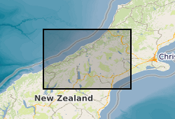
The dataset contains geochemical measurements which quantify the amount and source of carbon in organic matter of sediments from Lake Paringa, New Zealand. Measurements were made on a 6 m sediment core collected in 2015 from the lake bed using a Mackereth corer (PA6m1a). The core was correlated to master core PA1 which has a well-established age-depth model based on accelerator mass spectrometry measurements of the radiocarbon (14C) content of terrestrial macrofossils (Howarth et al., 2016). In addition, soil samples were collected using a soil auger from two elevation transects in westland, New Zealand in 2016 and 2017 (from Mt. Fox and Alex Knob). All sediment samples were freeze dried and ground to homogenise them prior to geochemical analyses. Organic carbon concentration (%) and the stable isotopic composition of organic carbon (δ13C) was measured (Frith et al., 2018) following the removal of carbonate minerals (0.25 M hydrochloric acid for 4 hours at approximately 70 °C) by combustion of sediment at 1,020 °C in a Costech Elemental Analyser coupled via a CONFLO III to a Thermo Scientific Delta V Advantage stable isotope mass spectrometer. Total nitrogen content (N, %) and its isotopic composition (δ15N) was measured by combustion of untreated samples in a Costech Elemental Analyser with a CARBOSORB trap to inhibit large CO2 peaks from affecting measurements. A subset of samples were selected for analysis of the radiocarbon activity (14C, reported as F14C) of bulk organic matter by accelerator mass spectrometry after graphitization. A subset of sediment samples from the lake core and soil samples were selected for the analysis of biomarker abundance and their hydrogen isotope composition. We focused on the extraction of n-alkanes from aliquots of lake sediment (~2 g) using established methods (Wang et al., 2020). These measurements are reported in the dataset as the abundance of n-alkanes (chain lengths C21 to C35) in ug/g of sediment (and sum of chain lengths and ratios - carbon preference index). Finally, the dataset includes outputs of organic matter provenance: modelled elevation and depth, as described in Wang et al., (2020). In the datafile, the sample elevation and depth are provided. The labels for data are as follows. For down core sediment samples from Lake Paringa, they are labelled with the core code (PA6m1), and the sampling interval in centimetres (PA6m1_x). Soil samples from an elevation transect from Mt Fox (MF-YY-a) are labelled with a distinct code for each site (YY) and sub-code for each soil depth (a). Soil samples from an elevation transect of Alex Knob (5.Z.z) are labelled based on sub-site (Z) and soil depth (z).
-
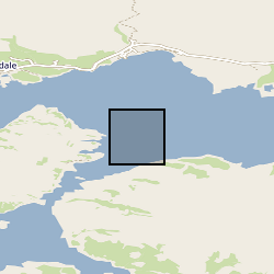
Geochemical data for the upper 300cm of giant piston core MD04-2832. Core MD04-2832 was collected from the middle basin of Loch Sunart a fjord on the west coast of Scotland from the research vessel Marion Dufresne on the 15th of June 2004. This data resource includes five data sheets: (1) Geochemical data, (2) Bulk radiocarbon, (3) ICP-MS, (4) FRUITS and (5) Age Model. 1. Geochemical data sheet includes Bulk elemental data (Organic Carbon, Nitrogen, C/N ratio, N/C ratio), Isotopic data (δ13C and ẟ15N), Biomarker data (Alkanes, Fatty Acids, GDGT's) and thermosgravimetric data (% labile, recalcitrant and refractory organic matter). 2. Bulk Radiocarbon data sheet includes bulk radiocarbon data for ten sediment samples presented as % modern, 14C Age (years BP), ẟ14C and Δ14C. 3. ICP-MS data sheet includes metal data associated with mining activities within the fjords catchment. Data includes Zinc (Zn), Lead (Pb), Copper (Cu), Barium (Ba), Aluminium (Al) and elemental ratios of these metal normalized with Al concentrations. 4. The FRUITS data sheet contains the outputs from the FRUITS Bayesian isotopic mixing model (Fernandes et al., 2014) used to constrain the source (terrestrial vs marine) of the organic carbon found at site MD04-2832. The model used bulk elemental ratios (N/C), Isotopic (δ13C and ẟ15N) and biomarker data (GDGT - BIT Index) to calculate the terrestrial and marine OC fraction from each downcore sample. 5. The Age Model datasheet contains the age model produced by the BACON software package (Blaauw and Christen, 2011). The age model was developed with a combination of shell/foraminifera radiocarbon dates and radiometric dating (210Pb and 137Cs). Further details on the data can be found in Smeaton, C., Cui, X., Bianchi, T.S., Cage, A.G., Howe J.A., Austin, W.E.N., (2021), The evolution of a coastal carbon store over the last millennium, Quaternary Science Reviews.
-
The dataset consists of eleven spreadsheet tabs, each tab containing lipid biomarker palaeothermometry (air temperature reconstructions) and bulk organic carbon isotope data from individual lignites that are known to stratigraphically span the Cretaceous-Palaeogene (K-Pg) boundary. Uncalibrated, raw biomarker distributions (glycerol dialkyl glycerol tetraethers; GDGTs) are provided, as well as the calculated calibration outputs. Site coordinates are: West Bijou, Colorado (39°34'14'N, 104°18'09'W), Sussex, Wyoming (43°39'40"N, 106°19'06"W), Pyramid Butte, North Dakota (46°25'03'N, 103°58'33'W), Hell Creek Road, Montana (47°31'35"N, 106°56'23"W), Rock Creek West, Saskatchewan (49°02'20"N, 106°34'00"W), Wood Mountain Creek, Saskatchewan (49°25'20"N, 106°19'50"W), Frenchman Valley, Saskatchewan (49°20’56"N, 108°25’05"W), Knudesn’s Coulee, Alberta (51°54’27"N, 113°02’57"W) Griffith’s Farm, Alberta (51°54’47"N, 112°57’51"W), Coal Valley Cores (GSC CV-42-2, Cores 1 and 2), Alberta (53°05’02"N, 116°47’ 40"W) Police Island, Northwest Territories (64°52'42"N, 125°12'33"W).