
Microsoft Excel
Type of resources
Available actions
Topics
Keywords
Contact for the resource
Provided by
Years
Formats
Representation types
Update frequencies
Scale
Resolution
-

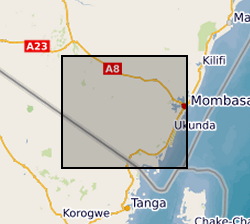
The file contain groundwater level/depth (WL), Groundwater and Surface Water Quality data (EC (micro-siemens per centimetre or µS/cm), Temperature (degrees C) and pH) for 49 points under fortnightly monitoring relevant to Gro for GooD research project in Kwale County, Kenya. Blank - Data not available. Note this is same dataset as NGDC record number 118189 with extended time series. Gro for GooD: Groundwater Risk Management for Growth and Development
-
Stable Isotope and trace element analyses (Ca, Sr, Mg, Fe and Mn concentrations) derived from Cretaceous Belemnites including Duvalia tornajoensis, D. cf. lata constricta, D. binervia, D. cf. emericii, Hibolithes, H. cf. jaculoides, Berriasibelus, Castellanibelus and Pseudobelus.
-

The data set comprises rhenium isotope compositions, rhenium concentrations, total organic carbon concentrations, and titanium concentrations measured from bulk rock digestions of the Eagle Ford Shale in South Texas, USA. The samples were obtained from coeval strata recovered in drill core Innes-1 and outcrop sections DR5 and DR12. The project aimed to compare the isotopic composition of Re before and after oxidative weathering. Rhenium concentrations were measured by isotope dilution, using liquid-liquid (alcohol) extraction and measurement by MC-ICP-MS. Rhenium isotopes were measured after a 3-stage column purification procedure using MC-ICP-MS. MC-ICP-MS measurements were made with the addition of a tungsten spike to correct for instrumental mass fractionation. Total organic carbon concentrations were measured by Rock-Eval pyrolysis (Rock-Eval VI) and Ti concentrations by ICP-AES.
-

PROJECT DETAILS ONLY - NO DATA. The processes by which frost shatters rock are subject to controversy. The main objective of the proposed research is to develop a new methodology for experimentally testing a model of ice segregation in permafrost. Using specialist cold-room facilities in the CRNS Centre de Geomorphologie, Caen (France), the methodology will simulate the bedrock thermal and hydrological regime at the top of cold permafrost in order to determine whether growth of segregated ice within the simulated permafrost shatters a large block of frost susceptible rock (chalk). Verification of the ice-segregation hypothesis by the proposed experiment would have international significance to the fields of permafrost science, engineering and rock weathering because it would emphasise the unified nature and consequences of ground-ice development in fine-grained soils and rocks.
-
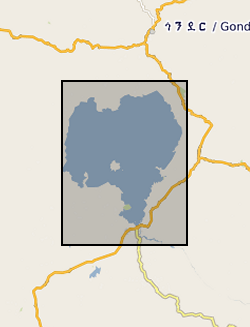
Zr/Rb, Ca/Ti, Rb/K ratios against depth (0.112 m to 62.686 m) and age ( 366 to 150190 yrs). NERC grant, NE/D012996/1, abstract Lake Tana, in the highlands of northern Ethiopia, is the source of the Blue Nile, one of the world's great rivers. Surprisingly, very little is known about the age and history of this lake: one estimate from the 1930's is that it was formed 10,000 years ago by a lava dam. Similarly, little is known about the climatic history of the wider region that comprises the Blue Nile headwaters, despite the fact that the Nile has long been recognized as critical to the resources of ancient and modern Egypt. New geophysical and core data, obtained by us in October 2003 and September 2004 with NERC support, show that the lake may be at least 40,000 years old. Our new data also show that the lake dried out at around 16,000 years ago, and almost certainly at apparently regular intervals during the later stages of the last Ice Age. It is possible that the lake dried because of intense droughts lasting one or two hundred years, and that the droughts were caused by disruption of Africa's monsoon climate when iceberg-laden meltwater from North America flooded the North Atlantic - the Heinrich events. In this new PalaeoTana Project, we aim to test these hypotheses by drilling a sediment core, up to 100m in length, from the northern basin of Lake Tana, in about 10m water depth, and about 2km from shore. The core will be scanned at high resolution using X-ray fluorescence, X-ray and colour imagery, geophysical and magnetic core-scanning technology, without damaging the sedimentary components. The resulting datasets will identify past desiccation events, which will be investigated in detail and interpreted by comparison to sediments of the known drying-out event at 16,000 years ago. Dating the sediments by appropriate methods including luminescence, tephrochronology, and Argon-Argon dating will allow precise estimates of the timing and duration of the drought events. The relative timing of these events in comparison with abrupt climatic events in ocean cores (especially Heinrich events), and in other continental records, will allow inferences about the global- scale mechanisms of abrupt climate change. The data can also be used to test climate models, and thus to help judge the accuracy of model-predicted abrupt climate change in the future. A long core record of past climate and environment from this part of Africa would have major significance for understanding both regional environmental change, because of the influence of the Nile on NE Africa and the eastern Mediterranean, and global climate. It will contribute to understanding how future changes in ocean temperature and circulation will affect global climate, especially in the heavily populated monsoon regions of Africa and Asia. It will also have significance for understanding the later stages of human evolution in and dispersal out of Africa, by providing a record of the environmental changes that influenced early human populations and their water, plant and hunting resources.
-

The datasets consist of a spreadsheets containing sporomorph and biomarker data for 145 samples from Eocene sediments recovered by Integrated Ocean Drilling Programme Expedition 318. We studied palynology (pollen and dinocysts) and palaeothermometry based on Glycerol Dialkyal Glycerol Tetraethers (GDGTs) to a sedimentary record from the Wilkes Land margin, East Antarctica, recovered by the Integrated Ocean Drilling Program (IODP Expedition 318 Site U1356). These data sets provide the framework for a terrestrial climate reconstruction for the early Eocene of Antarctica. Further details of the data and their interpretation may be found in Pross et al. (2012), doi:10.1038/nature11300 and Bijl et al. (2013), PNAS, doi/10.1073/pnas.1220872110 The associated NERC grant is NE/I00646X/1 and NE/I00646X/2.
-
Geological observations during field walks, with coordinates, photographs and descriptions of rocks/geological materials and features at the various stops.
-

Mineral and glass geochemical analyses (spot analyses) of samples recovered during IODP Expedition 398 (Site U1595). Site U1595 (proposed Site CSK-08B) is located in the southern basin of the Santorini caldera at 291 meters below sea level (mbsl). It was drilled in three holes (U1595A-U1595C) to a maximum recovery depth of 127.0 meters below seafloor. Some data files also contain SEM-BSE images of volcanic ash particles. Abbreviations used: n.d. = not determined; b.d. = below detection. Detection limits for volatiles in glass: Cl = 57 ppm, F = 140 ppm, S = 56 ppm Mineral and glass geochemical compositions were determined by electron probe micro-analysis, using facilities at the Natural History Museum London and at the University of Leeds. SEM-BSE images were generated at Keele University. Data analysis was supported by NERC - UK IODP Phase 4 Moratorium Award, NERC Grant NE/X016374/1, Ralf Gertisser. For sample context, see: https://publications.iodp.org/proceedings/398/398title.html https://doi.org/10.14379/iodp.proc.398.109.2024
-

Mineral geochemical analyses (core rim traverses of plagioclase and pyroxene) of samples recovered during IODP Expedition 398 (Site U1595). Site U1595 (proposed Site CSK-08B) is located in the southern basin of the Santorini caldera at 291 meters below sea level (mbsl). It was drilled in three holes (U1595A–U1595C) to a maximum recovery depth of 127.0 meters below seafloor. The data files also contain BSE images of plagioclase and pyroxene crystals that illustrate where the geochemical traverses were done. Mineral geochemical analyses and BSE images were generated by electron probe micro-analysis, using facilities at the Natural History Museum London. Data analysis was supported by NERC - UK IODP Phase 4 Moratorium Award, NERC Grant NE/X016374/1, Ralf Gertisser. For sample context, see: https://publications.iodp.org/proceedings/398/398title.html https://doi.org/10.14379/iodp.proc.398.109.2024
-

This data was collected in order to investigate the level of evidence for: A) a relationship between the strength of the geodynamo and Earth surface UV-B irradiance; B) increased surface UV-B irradiance during the Laschamps Event (the last major geomagnetic excursion, ca. 41ka BP). The study considered subfossil Pinus Diploxylon (Pinus D.) pollen grains obtained from the annually laminated Japanese Lake Suigetsu sediment record (Bronk Ramsey et al., 2020; Nakagawa et al., 2003). The primary response variable is the abundance of para-coumaric acid (a UV-B absorbing compound) in the sporopollenin of the subfossil pollen grains. The secondary response variable is the probability of grain malformation. There are three key spreadsheets: 1) GCMS_pCA_day_dependent_calbration_simple.csv - estimated abundances of para-coumaric acid in the subfossil Pinus Diploxylon pollen at different depths/times of the Lake Suigetsu sediment core. 2) Suigetsu_malformations_simple.csv - malformations counts in the Lake Suigetsu subfossil Pinus Dipoxylon pollen 3) gc_cultivar_data_simple.csv - estimated abundance of para-coumaric acid in Pinus pollen in a controlled cultivar experiment (considering response to UV-B flux) Descriptor files (with corresponding names) are also provided. This dataset contains data generated by NERC Grant NE/Y002652/1:Reconstructing UV radiation over the Laschamps Geomagnetic Excursion.