 NERC Data Catalogue Service
NERC_DDC
Type of resources
Available actions
Topics
Keywords
Contact for the resource
Provided by
Years
Formats
Representation types
Update frequencies
Service types
Scale
Resolution
-
Controlled CO2 release experiments and studies of natural CO2 seeps have been undertaken at sites across the globe for CCS applications. The scientific motivation, experimental design, baseline assessment and CO2 detection and monitoring equipment deployed vary significantly between these study sites, addressing questions including impacts on benthic communities, testing of novel monitoring technologies, quantifying seep formation/style and determining CO2 flux rates. A review and synthesis of these sites studied for CCS will provide valuable information to: i. Enable the design of effective monitoring and survey strategies ii. Identify realistic site-specific environmental and ecosystem impact scenarios iii. Rationalise regulatory definitions with what is scientifically likely or achievable iv. Guide novel future scientific studies at natural or artificial release sites. Two global databases were constructed in Spring 2013, informed by a wide literature review and, where appropriate, contact with the research project leader. i. Artificial CO2 release sites ii. Natural CO2 seeps studied for CCS purposes The location and select information from each of these datasets are intended to be displayed as separate GoogleMap files which can be embedded in the QICS or UKCCSRC web server. These databases are not expected to be complete. Information should be added as more publications or become available or more case studies emerge or are set up. To facilitate this process, a contact email should be included beneath the map to allow viewers to recommend new or overlooked study sites for the dataset. Grant number: UKCCSRC-C1-31. These data are currently restricted.
-

2 papers and supplementary information produced from NERC Grant NE/I006427/1. Lear, C. H., H. K. Coxall, G. L. Foster, D. J. Lunt, E. M. Mawbey, Y. Rosenthal, S. M. Sosdian, E. Thomas, and P. A. Wilson (2015), Neogene ice volume and ocean temperatures: Insights from infaunal foraminiferal Mg/Ca paleothermometry, Paleoceanography, 30, 1437–1454, doi:10.1002/2015PA002833. Elaine M. Mawbey, Caroline H. Lear; Carbon cycle feedbacks during the Oligocene-Miocene transient glaciation. Geology ; 41 (9): 963–966. doi: https://doi.org/10.1130/G34422.1
-
Description of peatland sites included in the compilation of carbon accumulation rates, including resolution (high, low), interpolation (yes/no), contributor name, country, lon, lat, peatland type, dominant plant type, no. of dates used in the last millenium carbon accumulation rate calculation, and problems with the data. Peatland sites at northern hemisphere high and mid latitudes (260), tropical (30) and southern hemisphere high latitudes (7 sites).
-
Geochemical data: %C, %OC, %IC, %N Physical Property data: Wet and dry bulk density, water content, porosity. Sediment cores extracted from Offshore Region: Loch Sunart NM 70277 63360, 56.705259, -5.7545471. For more information see published report, Substantial stores of sedimentary carbon held in mid-latitude fjords. / Smeaton, Craig; Austin, William; Davies, Althea; Baltzar, A.; Abell, R. E.; Howe, J. A. doi:10.5194/bg-13-5771-2016
-
The 5km Hex GS Landslides dataset shows a generalised view of the GeoSure Landslides v8 dataset to a hexagonal grid resolution of 64.95km coverage area (side length of 5km). This dataset indicates areas of potential ground movement in a helpful and user-friendly format. The rating is based on a highest level of susceptibility identified within that Hex area: Low (1), Moderate (2), Significant (3). Areas of localised significant rating are also indicated. The summarising process via spatial statistics at this scale may lead to under or over estimation of the extent of a hazard. The supporting GeoSure reports can help inform planning decisions and indicate causes of subsidence. The methodology is based on the BGS Digital Map (DiGMapGB-50) and expert knowledge of the behaviour of the formations so defined. This dataset provides an assessment of slope instability. Landslide hazard occurs due to particular slope characteristics (such as geology, gradient, sources of water, drainage, man-made constructions) combining to cause the slope to become unstable. Downslope movement of materials, such as a landslide or rockfall may lead to a loss of support and damage to buildings. Complete Great Britain national coverage is available.
-

Rotating Rayleigh-Benard convection. Table of the input and output parameters of the simulations. Snapshot of the temperature field, three components of the velocity and three components of the magnetic field in 3D. Data generated with a magnetohydrodynamical code of rotating Boussinesq convection in planar geometry (Cattaneo et al. 2003 ApJ 588 1183-1198). Data published in Guervilly, Hughes & Jones 2014 JFM 758 407-435 (DOI:10.1017/jfm.2014.542) and Guervilly, Hughes & Jones 2015 PRE 91 041001 (DOI: 10.1103/PhysRevE.91.041001)
-
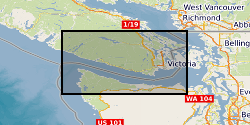
Detections of tremor at a set of template locations over the course of four slow slip events in 2004, 2008, 2009, and 2010. As well as identified bursts of tremor within these windows. The dataset consists of: Detected spikes in the tremor time series Each file contains a list of identified spikes in the inter-component coherence time series. LFE (Low frequency earthquakes) locations The locations of LFEs identified by Bostock, M. G., Royer, A. A., Hearn, E. H., and Peacock, S. M. (2012), Low frequency earthquakes below southern Vancouver Island, Geochem. Geophys. Geosyst., 13, Q11007, doi:10.1029/2012GC004391. Cp values through time 12 files containing time series of inter-component and/or inter-station coherence at a range of LFE locations Further descriptions are available in the README and in the preprint hosted on EarthArxiv: Gombert and Hawthorne, Rapid tremor migration during few minute-long slow earthquakes in Cascadia, 2022, doi: 10.31223/X56623.
-
This dataset contains a catalogue of in-situ models for a fault activated by hydraulic fracturing in the Horn River Basin in July 2011. These were created as a part of Kettlety et al. (2019), wherein a Monte Carlo analysis was used to assess fault stability. See attached readme file for more details.
-

The data set contains two separate items: (1) Global carbon dioxide removal potential of mine tailings, which includes (a) List of selected silicate-hosted mine tailings (classified by their targeted commodity and typical host rock) for initial assessment of CO2 removal (CDR) potential; (b) Estimated annual and cumulative production (Mt) of suitable tailings for host countries for the years 2030-2100; (c) Assessed deposit types and associated tailings mineralogies; (d) Summary kinetic data for typical targetable minerals in suitable tailings; (e) Effects of mineral compositional (and end member) variations on dissolution rates under unimproved conditions (Wr-Neut); (f) All compiled mineral data used in the GGREW global assessment study and other complimentary GGREW studies; (g) Estimates of dissolution extent over time (on decadal timescales of up to 70 years) for a theoretical 1 kg of tailings material at typical grain sizes and unimproved conditions (using Wr-Neut); (h) Total cumulative CDR (tCDR; MtCO2 as alkalinity); (i) Estimated CDR capacity (cumulative for the estimated annual tailings production at 2030 (sCDR) and total cumulative CDR (tCDR) as alkalinity for 2050 and 2100) for select countries that produce and host suitable tailings; (j) CDR achieved annually by country (2030-2100), under unimproved and improved conditions; and (k) Sources of information for modal mineralogies, commodity production to tailings production ratios and typical grain sizes for each potentially suitable tailings material type. (2) Results of enhanced weathering reactor optimisation with two objectives, namely energy consumption and space (area) requirement, which include the optimisation output for calcite weathering using trickle-bed reactor, calcite weathering using packed-bubble column and forsterite weathering using packed-bubble column. For each of them, the data includes key reactor design parameters, the two objectives, and key process characteristics (particularly, mass transfer performance and mineral dissolution rates).
-

Each of this set of 3D X-ray tomography datasets show a particle “bead pack” developed as a magmatic mush analogues but of use to anyone investigating non-spherical systems. The stack of tiff images in each 3D dataset show either cuboid, rod and disc/plate like particles as well as irregular shapes and mixtures of these. The data were used to measure packing geometries, contact areas, and pore volumes, surface areas and connectivity, and perform permeability simulation used to develop advanced porosity-permeability relationships for any bead packing geometry. The data were collected on a Nikon XCT scanner with the exact imaging condition for each scan presented in the txt settings file in each folder (including x-ray energy, flux and resolution information). The data may be of use to those developing advanced finite element, discrete element or flow models in complex packed beds.