 NERC Data Catalogue Service
10000
Type of resources
Available actions
Topics
Keywords
Contact for the resource
Provided by
Years
Formats
Representation types
Update frequencies
Scale
Resolution
-
This dataset (GSE_SPECIMENS) is an index of the specimens and palaeontological slides held in the Type and Stratigraphical (T&S) Collection of Scotland and Northern England. This index along with GSE_REFERENCES (List Of Specimens From The UK (North) Type And Stratigraphical Collection And Related Publications) and to some extent SMITH_GSE (Index To Specimens Transferred From The John Smith Collection To The UK (North) Type and Stratigraphical Collection) are the digital equivalents of the analogue card index (held in BGS Edinburgh). The latter contains c.16k records, of which perhaps 25% have been transcribed. The sporadically growing T&S Collection (which is derived from the Survey Collection) comprises some 16k specimens. About 11k are housed at BGS Keyworth and c.5k remain at BGS Edinburgh. The specimens are individually registered in 5 leather bound volumes. These are held in BGS Keyworth, but equivalent information (microfilm and paper records) is held in BGS Edinburgh. For each specimen, the MS Access database MTD_GSE_SPECS provides a link with the Survey Collection, gives nomenclatural, taxonomical, geographical and stratigraphical information, an indication on where the fossil is housed, and any comments, perhaps on the state of preservation.
-

Data from projects that investigated the migration, transport and retardation processes of naturally occuring trace elements, as analogues the behaviour in the geosphere environment, of radionuclides from radioactive wastes. Study sites included: the Quaternary Broubster Peat Bog, near Thurso in Caithness (study of the migration behaviour and characteristics of U, Th, Ra, Pb, Cu, Zn, organic complexes such as fulvic and humic acids); the Needle's Eye site (Quaternary estuarine and marsh/mudflat sediments) on the Solway Coast of Dumfries and Galloway (study of the migration and retardation behaviour of U in Quaternary sediments and fractured Palaeozoic source rocks); Study of U geochemistry and transport behaviour from uranium-rich mine wastes at the South Terras Mine site, near St Austell, Cornwall; Study of the geochemistry of diffusion of Cl and I from marine source sediments into lacustrine sediments in Quaternary sediments from Loch Lomond. Data consists entirely of published reports of geological, geochemical, hydrochemical petrological and mineralogical information. The data includes descriptive and numerical data but is not digitally available in its present state.
-

1. Grids (in spreadsheet form) of interpreted parameters from the 3D time-lapse seismics (temporal and constructed depth thicknesses) at the Sleipner CO2 storage operation in the North Sea. 2. A synthetic seismic model of a CO2 wedge, to examine the relationship between wedge true thickness and temporal thicknesses. These datasets underpin following publications: Chadwick, R.A., Williams, G.A. & White, J.C. 2016. High resolution imaging and characterisation of a CO2 layer at the Sleipner CO2 Storage operation using time-lapse seismics. First Break, 34, 79-87. The source data comprise the Sleipner 3D time-lapse surveys which were acquired in 1994 (baseline), 1999, 2001, 2002, 2004, 2006, 2008 and 2010. The dataset used here for measuring temporal thicknesses is the 2010 high resolution dataset with constructed depth thicknesses from the 1994 baseline data. Grant number: EP/K035878/1.
-
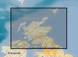
In 2011 the British Geological Survey (BGS) decided to begin the assembly of a National Geological Model (NGM) from its existing and on-going geological framework models , comprising integrated national crustal, bedrock and Quaternary models. The bedrock component is the most advanced of these themes and comprises both the calculated models and a complementary network of cross-sections that provide a fence diagram for the bedrock geology of Great Britain. This fence diagram, the GB3D_v2012 dataset is available in a variety of formats from the BGS website www.bgs.ac.uk as free downloads. It complements the existing 1:625 000 scale mapsheets published by BGS utilising the same colour schema and geological classification. The 121 component cross-sections extend to depths between 1.5 and 6 km; they have an aggregate length of over 20,000 km, and they are snapped together at their intersections to ensure total consistency. The sections are based on the existing BGS geological framework models where they cut through them, they also take account of the vast wealth of published data on the subsurface structure of Britain both from BGS and in the literature. Much of this is in the form of cross-sections, contour maps of surfaces, and thicknesses (isopachs). The fence diagram has been built in the Geological Surveying and Investigation in 3D (GSI3D) software. It is envisaged that this dataset will form a useful educational resource for geoscience students and the general public, and also provide the bedrock geology context and structure for regional and catchment scale studies. The fence diagram was built in 2009-12 using funding from the BGS National Capability Programme and the Environment Agency of England and Wales. 14 expert regional geologists compiled the sections.
-

Structural geology data obtained by Land Survey staff during their mapping work. Originally designed for the Mid-Wales Mapping Programme but subsequently used by other teams. Holds details of planar structures, linear structures, folds, faults and veins.
-
The Land Survey Record Index was set up c.1988 to provide a digital database index to records and archives held by the Land Survey in Scotland and Northern England and contains over 46,600 records. Finding aid to the following record groups/data sets, is provided through a application query interface: Site Investigation Records (SE); Land Survey Archives (LSA); Land Survey Records (LSR); Mineral Resource Records (MR); Additional Information Files (AI); Enquiry Record Files (EE; EN); Opencast Coal Sites (OC).
-

The BGS database of geological maps is an index into BGS holdings of modern and historical published geological maps, geological standards and field slips, and also contains a range of other map series, including geophysical maps, geochemical maps, hydrogeological maps, thematic maps and other small-scale miscellaneous non-series maps. Historical vertical and horizontal sections, as well as indices to colours, are also included. The database comprises map metadata, including the title, theme, survey and revision years, publication years, mapped geological theme, base material, map function, colouration, approval status and the spatial extent of each map sheet. An accompanying file store contains high-resolution JPEG2000 scans for delivery, as well as various digital master and delivery formats. For a small number of maps, no scan exists. In total, the database contains over 240,000 scans of over 130,000 maps and field slips. The majority of the maps in the database cover Great Britain, but other regions are also represented, including a historical series of 1-inch maps of Ireland, 6-inch maps of the Isle of Man, 1:25 000 scale maps of the Channel Islands, and various overseas maps. The database contains a record of all geological maps produced by the British Geological Survey and its predecessors since the commencement of systematic geological mapping in the 1830s. The BGS Maps Database is mostly an archive of previous BGS maps, and is not the same as the latest BGS digital mapping. The maps within the database may differ significantly from BGS digital vector mapping. Further information about BGS digital vector mapping is available on the BGS website, under 'BGS Datasets'. The database has evolved over time, originally being a series of discrete databases. These databases have now been aggregated into a single dataset. BGS published maps, as well as 1:10 560 and 1:10 000 large-scale geological maps of England and Wales, and Scotland, are available through the BGS Maps Portal. Field slips and some thematic maps are not included on the BGS Maps Portal. The information about a map is normally a transcription from the map itself. Sometimes key information such as the title may not be actually printed on the map. Where this is the case the information is supplied in square brackets, e.g. [Kirk Maiden]. Information in square brackets means the information is supplied by the cataloguer and is not transcribed from the item.
-
The Britrocks database provides an index to the BGS mineralogical & petrological collection. The computer database covers samples in the UK onshore mapping collection together with world wide reference minerals and the Museum Reserve collection. Currently circa 200k out of circa 300k samples are recorded in the computer database. A collection audit is ongoing, so availability of any particular sample is not guaranteed. The first England and Wales collection sample is from circa 1877, Threshthwaite Comb, Cumbria (collected by the Reverend Clifton Ward). The addition of new samples, transfer of records from registers and updates of existing records is ongoing on a regular basis. Internet access to the database is provided on the BGS web site.
-
Collections of miscellaneous items mainly of semi-current value, including some field observations supplementary to 1:10560/1:10K mapping, arranged on 1:10K or One-Inch sheet basis. Set up in 1950's filing miscellaneous records for Scotland and Northern England. Records of archival value for permanent retention being transferred to Land Survey Archives (LSA). Indexed in the Land Survey Record Index (LSRI).
-
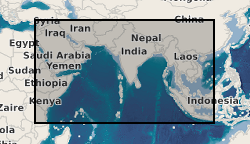
Data from geophysical surveys carried out by the British Geological Survey in many countries in the Middle East, the Indian sub-continent and Indo-China for different agencies. The surveys range from regional gravity and airborne magnetic mapping to targetted surveys for mineral and water. Individual surveys do not yet have metadata entries: this entry describes a notional database that represents all geophysical surveys carried out within the region.