 NERC Data Catalogue Service
Water resources
Type of resources
Topics
Keywords
Contact for the resource
Provided by
Years
Formats
Representation types
Update frequencies
-
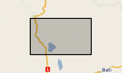
In 1998 the Department for International Development (DFID) funded the project ‘Groundwater drought early warning for vulnerable areas’ as part of the DFID Knowledge and Research (KaR) programme, a collaboration between UK partners BGS and the Overseas Development Institute (ODI), and with the Bureau of Water, Mines and Energy in Amhara Region, Ethiopia. Drawing on village surveys and stakeholder consultations across sectors, this project evolved a broader, more holistic approach to the study of drought and water supply. Rather than focus exclusively on drought and water availability, constraints on household access to and use of water were explored through the lens of water security. This, in turn, highlighted links between the household water economy (across seasons; between good and bad years) and wider livelihood strategies, particularly in relation to inter-dependencies between food and water security.
-

The data are transcripts of qualitative community surveys carried out in Amuria (A) and Katakwi (K) districts, north-eastern Uganda, as part of a pilot project looking at causes of borehole/hand pump failure in rural areas. The community survey was designed to collected basic information on community water use, reconstruct the history of the water point and explore the socio-institutional factors that may have contributed to non-functionality. Key topics included: community engagement in planning and construction of the water point, access to the water point (and alternative water sources), water quality and yield (including seasonality), mechanical failures and repairs, water point management and by-laws, and fees and finances. The survey took the form of a semi-structured group discussion, guided by a set of questions covering the key topics. Each survey took 2-3 hours. Surveys were conducted for 24 water points. Participants included both water users and Water Point Committee (WPC) members. There were no restrictions on who from the community could participate in the discussion, hence numbers varied. The focus groups were facilitated by local NGO staff familiar with the districts, and guided by researchers from the Overseas Development Institute. The transcripts were produced from the detailed handwritten notes taken by the researchers during the group discussions, with the support of translators. The community surveys should be viewed as complementary to the technical investigations conducted at the borehole.
-
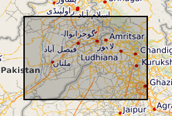
The groundwater systems of northwest India and central Pakistan are amongst the most heavily exploited in the world. Groundwater has been monitored in the region for more than a century resulting in a unique long-term record of groundwater level change. The BGS has compiled groundwater level data from northwest India (Haryana and Punjab) and Pakistan (Punjab) between 1884 and 2020. The dataset, presented here, was compiled from various sources between 2018 and 2020. The excel file consists of two tabs both containing groundwater level data (in metres below ground level) and location information. In the first tab (Full_dataset), which contains the full dataset, there are 68783 rows of observed groundwater level data from 4028 individual sites. In the second tab (LTS) there are 7547 rows of groundwater level observations from 130 individual sites, which have water level data available for a period of more than 40 years and from which at least two thirds of the annual observations are available.
-

In developing countries, the dominant model for managing rural water supplies is a community-level association or committee. Although a relative paucity of evidence exists to support this model, it continues to exert a strong pull on policy makers. The Hidden Crisis Survey 2 dataset is the major dataset developed by the project. A social science and physical science survey were conducted in tandem, examining the physical waterpoint and the arrangement the community had devised for managing it. The detailed physical and social science datasets developed by the survey were intended to be used to: better understand the multi-faceted factors which underlie water source failure, their everyday governance arrangements, and to explore the inter-relations between the water point governance arrangements, engineering choice and performance, and groundwater resource conditions. The social science survey moved beyond the more standard preoccupation with examining waterpoint committees (a focus on form) to instead examine context-specific water management arrangements (based on the functions needed for sustainable and equitable management). The survey produced a detailed social science dataset of the arrangements communities have devised for managing their waterpoint across 150 sites in Ethiopia, Malawi and Uganda, surveyed in 2017 and the early part of 2018 (fieldwork was staggered across the three project countries to time with their dry seasons). The findings challenge many of the normative assumptions in the literature about community based management of water and help to move the debate on to more productive areas of enquiry.
-
In developing countries, the dominant model for managing rural water supplies is a community-level association or committee. Although a relative paucity of evidence exists to support this model, it continues to exert a strong pull on policy makers. This project examines everyday water governance arrangements, situating these in the exigencies of wider village life and over the course of changing seasons. The data highlights the social embeddedness of water governance, and challenges the dominant 'associational model' of community based management. In none of the 12 sites do we observe a fully formed committee functioning as it should according to policy. Instead, water management arrangements are typically comprised by one or a small number of key individuals from the community, who may or may not be part of a waterpoint committee.