Geothermal energy
Type of resources
Topics
Keywords
Contact for the resource
Provided by
Years
Formats
Representation types
Update frequencies
Scale
Resolution
-
Geological model comprising artificial ground and superficial deposits in the city of Cardiff. Undifferentiated bedrock is included beneath the superficial deposits. This model provides a geological framework model and calculated surfaces for the superficial deposits for the city of Cardiff, principally Till, Glaciofluvial deposits, Alluvium and Tidal Flat Deposits.
-
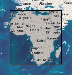
A geographic information system (GIS) containing geo-data for the energy transition across continental Africa created by extracting data from open sources into a series of shapefiles and rasters containing information on culture, geology, geothermal and geophysical data. This data is stored in the World Geodetic System (WGS) 1984 Geographic Projection System.
-
This raster dataset shows the modelled P50 distribution of the theoretical potential 'heat-in-place' (HIP) across the northern and southern early Carboniferous limestone in Great Britain (PJ/km2), at a resolution of 2500 m x 2500 m. The HIP is calculated for resource temperatures greater than 50°C, which represents the minimum temperature required for direct use of heat from hot sedimentary aquifer resources. The HIP characterises the heat resource available in an aquifer according to the USGS definition described in e.g. Muffler and Cataldi (1978). Its calculation is part of the research published by D J.R. Jones, T. Randles, T. Kearsey, T.C. Pharaoh, A. Newell (2023). https://doi.org/10.1016/j.geothermics.2023.102649. Areas of high uncertainty are delineated in the published paper.
-
This raster dataset shows the modelled P50 distribution of the theoretical potential 'heat-in-place' (HIP) across the combined Upper Devonian Kinnesswood Formation and Stratheden Group in the Midland Valley of Scotland (PJ/km2), at a resolution of 500 m x 500 m x 50 m. The HIP is calculated for resource temperatures greater than 50°C (> 1400 m depth), which represents minimum temperature required for direct use of heat from hot sedimentary aquifer resources. The HIP represents the heat resource available in an aquifer according to the USGS definition described in e.g. Muffler and Cataldi (1978). Its calculation is part of the research published by Kearsey, T.I., Receveur, M. and Monaghan, A.A., 2024. Modelled hot sedimentary aquifer geothermal potential of Upper Devonian strata in the Midland Valley of Scotland. The model is presented with high uncertainty.
-
This raster dataset represents the calculated temperature distribution (°C) at the base of the Permo-Triassic (PT) in the Cheshire and Worcester basins, considered for their hot sedimentary aquifer geothermal resource potential. The extent of the temperature maps corresponds to the extent of the modelled base PT in each basin. The maps are provided in raster format at a 100 m resolution and are based on temperature data from the latest revision of the UK Geothermal Catalogue (1987) compiled during the 1977-1991 Geothermal Energy Programme. For all basins taken together, the temperature ranges between 8.0°C to 104.6°C, with the highest temperatures found at depth in the Cheshire Basin. The dataset is used as a basis for the determination of the heat resource potential of the Permo-Triassic hot sedimentary aquifer resources (heat-in-place and heat recoverable).
-
This raster dataset represents the thickness in metres of the Carboniferous Fell Sandstone Formation (Mid Border Group) in the Northumberland-Solway Basin. The maps are provided in raster format at a 100 m resolution.
-
This raster dataset represents the depth in metres to the top of the early Carboniferous limestone (ECL) over the Northern and Southern Provinces in Great Britain. The grids are provided at a 2500 m resolution. The layer can be used to identify prospective geothermal heat resources, such as areas with deep burial depths beneath thick Permian-Mesozoic sequences, as in the Cheshire Basin, and the flanks of the East Irish Sea and Southern North Sea basins; or beneath thick later Carboniferous strata, as in the Stoke-on-Trent area.
-
This vector dataset represents the calculated, estimated temperature distribution at 100 m depth. Method described in Busby, J., Lewis, M., Reeves, H. and Lawley, R., 2009, August. Initial geological considerations before installing ground source heat pump systems. Geological Society of London.
-
This raster dataset represents the distribution of the estimated, theoretical potential 'geothermal resources' (in GJ/m2 or PJ/km2) for the Triassic sedimentary aquifers of the Sherwood Sandstone Group (SSG) in the East Yorkshire-Lincolnshire, Cheshire, Wessex and Worcester basins, for resource temperatures greater than 40°C. This grid is the heat-in-place, and represents the amount of heat contained in the productive parts of the identified aquifers (i.e. with sufficient porosity and permeability to be considered as a hot sedimentary aquifer resource). The maps are provided in raster format at a 100 m resolution.
-
This raster dataset represents the calculated temperature distribution (°C) at the base of the Sherwood Sandstone Group (SSG) in the main Permo-Triassic Cheshire, Wessex and Worcester basins and the intra-SSG temperature in the East Yorkshire-Lincolnshire Basin, considered for their hot sedimentary aquifer geothermal resource potential. The extent of the temperature maps corresponds to the extent of the modelled base SSG in each basin. The maps are provided in raster format at a 100 m resolution and are based on temperature data from the latest revision of the UK Geothermal Catalogue (1987) compiled during the 1977-1991 Geothermal Energy Programme. For all basins taken together, the temperature ranges between 5.3°C to 103.7°C, with the highest temperatures found at depth in the Wessex Basin. The dataset is used as a basis for the determination of the heat resource potential of the Triassic hot sedimentary aquifers in the UK (heat-in-place and heat recoverable).