
50 urn:ogc:def:uom:EPSG::9001
Type of resources
Available actions
Topics
Keywords
Contact for the resource
Provided by
Years
Formats
Representation types
Update frequencies
Scale
Resolution
-
The dataset contains the radiocarbon age of soil organic matter fractions collected along grassland-to-forest conversion chronosequences across Scotland. Soil samples were collected in summer 2018. In summer 2019, soil samples were fractionated and the radiocarbon age of bulk soil and soil fraction samples determined by accelerator mass spectrometry. Full details about this dataset can be found at https://doi.org/10.5285/0dd45f6f-0536-4ee3-9932-58bac019d2c6
-
This dataset contains Dissolved oxygen concentrations from two different locations in Durleigh Reservoir in Somerset, England. Two miniDOT oxygen loggers were fitted with miniWIPERs and deployed at two locations in Durleigh on 30 May 2018. Both sensors were collected on 5 October 2018 and the raw data files are presented in this dataset. Full details about this dataset can be found at https://doi.org/10.5285/26b35c45-c174-4930-b82c-bcd0d23c39e1
-
The dataset contains stem respiration (ppm) of 320 trees with DBH (Diameter at breast height) > 26 cm, measured with the EGM-4 (Environmental Gas Monitor for CO2). Data were collected on October 2019. In relation to the soil respiration dataset, it contains soil respiration (µmol CO2m-2 s-1) of different type of collars placed on the forest floor, and measured with the LI – 8100 A soil respiration system. Data were collected from June 2017 to October 2019. In both activities, leak tests were done before collections. All research was conducted in a field site approximately 80 km north of Manaus, in the state of Amazonas, Brasil. Full details about this dataset can be found at https://doi.org/10.5285/591e3708-7ff1-483b-9156-15c721c00daf
-
This dataset contains the dive times (dive start time and dive end time) and depths (maximum depth attained on a dive) of three species of auk from the Isle of May outside the seabird breeding season. Data were collected from 12 Atlantic puffin individuals (Fratercula arctica), 13 common guillemot (Uria aalge) and 13 razorbill (Alca torda). Atlantic puffin data were collected between 19th July 2008 to 3rd December 2008; common guillemot data from 20th July 2005 to 28th January 2006; razorbill data from 1st July 2008 to 24th January 2009. Full details about this dataset can be found at https://doi.org/10.5285/6ab0ee70-96f8-41e6-a3e3-6f4c31fa5372
-
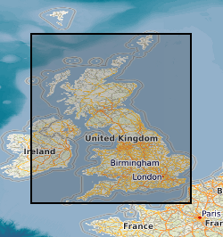
This dataset is part of Integrated Hydrometric Units (IHU) of the UK. Hydrometric Areas are used to organise river flow measurement and hydrometric data collection in the UK. Hydrometric Areas are either integral river catchments having one or more outlets to the sea or tidal estuary, or they may include several contiguous river catchments having topographical similarity but separate tidal outlets. In mainland Britain they are numbered from 1 to 97 in clockwise order around the coast commencing in north east Scotland. The larger islands and groups of islands are numbered from 100-108. Ireland has a unified numbering system from 1 to 40 commencing with the River Foyle catchment and circulating clockwise; not all Irish Hydrometric Areas, however, have an outlet to the coast. Only those Hydrometric Areas covering Great Britain and Northern Ireland are included in this dataset. The boundaries between hydrometric areas correspond to catchment boundaries as digitally-derived from CEH Integrated Hydrological Digital Terrain Model (IHDTM) using a catchment definition program. It should be noticed that the Northern Ireland data are clipped to its political boundary so not every Hydrometric Area in this region is completely represented. The naming and numbering convention for the hydrometric areas in Great Britain was originally defined by the Inland Water Survey Committee (and first published in the Surface Water Year-Book of Great Britain 1936-37). For Northern Ireland the system was developed by a multi-agency working group in the 1970s (and first published in Surface Water: United Kingdom 1971-73. Note that full citations of those two publications are provided as additional information source. This dataset represent the same entities as the IHU Hydrometric Areas of the UK without Coastline, however, the outer boundaries of the units follow coastline published by the Ordnance Survey (Meridian 2), rather than the boundaries of the CEH Integrated Hydrological Digital Terrain Model. Full details about this dataset can be found at https://doi.org/10.5285/1957166d-7523-44f4-b279-aa5314163237
-
The dataset contains light penetration through the water column at a Durleigh Reservoir in Somerset, England. HOBO Pendant Temperature/Light 8K Data Loggers (Onset) were positioned at 0.5 m, 1.5 m, and 2.5 m depths on a temperature chain Durleigh. The loggers were deployed between 30 May 2018 and 5 October 2018. Full details about this dataset can be found at https://doi.org/10.5285/fc1cf9a7-d7b0-4948-8328-497d6e071950
-
This dataset consists of invertebrate abundance data and associated ecosystem measurements (Including leaf litter depth and mass, seedlings, soil moisture and nutrients, and rainfall) measured within an area of lowland, old growth dipterocarp rainforest in the Maliau Basin Conservation Area, Sabah, Malaysia between 2015 and 2016. Data were collected during a collaborative project which was included in the NERC Human-modified tropical forest (HMTF) programme. Full details about this dataset can be found at https://doi.org/10.5285/1e9993ae-add7-497a-b54b-745b0fc6a7ca
-
A series of tiled models of superficial thickness covering the UK. The models are derived by direct modelling (natural neighbour interpolation) of BGS borehole records and BGS DiGMapGB-50. For the purposes of modelling, superficial deposits include sediments deposited during the Quaternary, subsequent Holocene rivers and coastal systems and also modern anthropogenic material, i.e. deposits that are less than 2.6 million years old. The 50 m x 50 m grids are overprinted with a minimum value so that areas where no bore data is present, but drift is known to occur, are given a minimum 1.5 m thickness. The superficial thickness models have been created as baseline datasets for the BGS Geohazard programme. They represent the first attempt by BGS to create nationwide models of such data and the models provide only a simple, mathematical interpretation of reality. The complexity of superficial deposits in Great Britain is such that it is only possible to model indicative values of thickness and elevation. The models should never be used as a substitute for thorough site investigation. The SDTM comprises three individual datasets; two datasets describe thickness variation and a third dataset details 'proximity' of the modelled data to the original source information. 1. The ASTM (Advanced Superficial Thickness Model) is a model of thickness variation indirectly derived from archive borehole records and map data. 2. The BSTM (Basic Superficial Thickness Model) is a model of thickness variation directly derived from archive borehole records. 3. The DBUFF (distance buffer) dataset is a calculation of spatial distance to the location of any data point used in the model. This provides the user with an indication as to how far the computer has had to interpolate and extrapolate the data from a measured observation point. For more information, refer to the user guide: The National Superficial Deposit Thickness Model (version 5). BGS Open Report OR/09/49. https://webapps.bgs.ac.uk/data/publications/publication.html?id=19867430
-
This dataset contains a list of all known birds, bryophytes, fungi, invertebrates, lichens and mammals that use oak (Quercus petraea and Quercus robur) in the UK. In total 2300 species are listed in the dataset. For each species we provide a level of association with oak, ranging from obligate (only found on oak) to cosmopolitan (found on a wide range of other tree species). Data on the ecology of each oak associated species is provided: part of tree used, use made of tree (feeding, roosting, breeding), age of tree, woodland type, tree form (coppice, pollarded, or natural growth form) and season when the tree was used. Data on use or otherwise by each of the 2300 species of 30 other alternative tree species (Acer campestre, Acer pseudoplatanus, Alnus glutinosa, Betula pendula, Betula pubescens, Carpinus betulus, Castanea sativa, Fagus sylvatica, Fraxinus excelsior, Ilex aquifolium, Larix spp, Malus sylvestris, Picea abies, Pinus nigra ssp. laricio, Pinus sylvestris, Populus tremula, Prunus avium, Pseudotsuga menziesii, Quercus cerris, Quercus rubra, Sorbus aria, Sorbus aucuparia, Sorbus torminalis, Taxus baccata, Thuja plicata, Tilia cordata, Tilia platyphyllos, Tilia vulgaris, Tsuga heterophylla, Ulmus glabra) was also collated. A complete list of data sources is provided. Full details about this dataset can be found at https://doi.org/10.5285/22b3d41e-7c35-4c51-9e55-0f47bb845202
-
This dataset contains seven month monitoring of weather conditions at Durleigh Reservoir in Somerset, England, during 2018. A Delta T WS-GP1 weather station was installed approximately 4 m above the surface of the reservoir between 5 April and 5 October 2018. Full details about this dataset can be found at https://doi.org/10.5285/dcfa74ce-6d05-4717-978d-e7cdf9b2039e