 NERC Data Catalogue Service
ESRI ASCII Grid (ASC)
Type of resources
Available actions
Topics
Keywords
Contact for the resource
Provided by
Years
Formats
Representation types
Update frequencies
Scale
Resolution
-

The dataset contains detailed Digital Elevation Models (DEMs), generated from Airborne LiDAR. The data is owned by the Environment Agency and is provided to BGS for research use only. Very limited UK coverage, limited mostly to floodplains. Light Detection and Ranging (LiDAR) is an airborne mapping technique which uses a laser to measure the distance between the aircraft and the ground. This technique results in the production of a cost-effective terrain map suitable for assessing flood risk. The aircraft flies at a height of about 800 metres above ground level and a scanning mirror allows a swathe width of about 600 metres to be surveyed during a flight. Individual measurements are made on the ground at 2 metre intervals allowing a highly resolved model of the terrain to be generated. The Agency's Flood Defence function has a requirement under the Water Resources Act 1991 to monitor the flood plain. LiDAR is being used to measure land topography and assess coastal erosion and geomorphology. Products that can be generated from the LiDAR data include colour coded elevation models, height contour plots and three-dimensional perspective views allowing easy visualisation of surveyed areas.
-

A digital elevation model for the Holocene surface around the area known as the Humber Estuary. The model was created as part of the Estuaries Reasearch Programme (EMPHASYS).
-

A digital elevation model for the Holocene surface around the area known as Southampton Water. The model was created as part of the Estuaries Reasearch Programme (EMPHASYS)
-

A digital elevation model of the base of the Holocene for the Mersey estuary. The model was created as part of the Estuaries Research Programme (EMPHASYS).
-
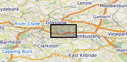
The UK Geoenergy Observatories (UKGEOS) Glasgow 3D coal mine model outputs, created by the British Geological Survey, provide a semi-regional overview of the depth and extent of surveyed and probable coal mine workings, plus stone and coal roads surveyed within the mines. The model allows users to visualise the surveyed and probable coal mine workings to be found beneath this part of Glasgow, applicable at a scale of around 1: 25,000 to 1: 10,000. The data is supplied as grids, triangulated surfaces over a 5 by 4.15 km area, with the depth range to around 300 m below Ordnance Datum. The mine extents are ‘cut out’ of the UKGEOS Glasgow pre-drill bedrock model. This model describes both surveyed (recorded on mine abandonment plan) and probable coal mine workings before the UKGEOS Glasgow boreholes have been drilled, and was used to inform the expected sequence on drilling. Further details and model limitations can be found in the accompanying metadata report http://nora.nerc.ac.uk/id/eprint/522737
-
The BGS Debris Flow Susceptibility Model for Great Britain v6.1 is a 1:50 000 scale raster dataset of Great Britain providing 50 m ground resolution information on the potential of the ground, at a given location, to form a debris flow. It is based on a combination of geological, hydrogeological and geomorphological data inputs and is primarily concerned with potential ground stability related to natural (rather than man-made) geological conditions and slopes. The dataset is designed for those interested specifically in debris flow susceptibility at a regional or national planning scale such as those involved in construction or maintenance of infrastructure networks (road or rail or utilities), or other asset managers such as for property (including developers and home owners), loss adjusters, surveyors or local government. The dataset builds on research BGS has conducted over the past 15 years investigating debris flows. The model was designed to identify potential source-areas for debris flows rather than locate where material may be deposited following a long-run-out failure i.e. the track and flow of debris. This work focuses on natural geological and geomorphological controls that are likely to influence the initiation of debris flows. It therefore, does not consider the influence of land use or land cover factors.
-

The UK Geoenergy Observatories (UKGEOS) Glasgow superficial deposits GSI3D model outputs, created by the British Geological Survey, provide a semi-regional overview of the depth, thickness and extent of glacial and post-glacial lithostratigraphic units above rockhead. The model allows users to visualise the likely subsurface sequence to be found beneath this part of Glasgow, applicable at a scale of around 1: 25,000 to 1: 10,000. The data is supplied as grids and shapefiles over a 7 by 4.15 km area, with the depth range to around 40 m below Ordnance Datum. This model describes an interpretation of the shallow geology updated to incorporate the results of drilling the 12 UKGEOS Glasgow boreholes (post-drill model). Further details and model limitations can be found in the accompanying metadata report http://nora.nerc.ac.uk/id/eprint/531155/ . DOI: https://doi.org/10.5285/915f690f-32cf-41b7-984e-c32344d3a543
-
The BGS Geochemical Baseline Survey of the Environment (G-BASE) was the national strategic geochemical mapping programme in Great Britain. The project set out to establish the chemistry of the surface environment by the collection and analysis of stream sediment, stream water and soil samples. Beginning in the late 1960s in northern Scotland and moving southwards across the country, the primary focus was mineral exploration, however, the project quickly developed to address important environmental concerns. The final G-BASE samples were collected in southern England in 2014. The outputs from the G-BASE project provide an invaluable, systematic baseline of geochemical information for Great Britain, serving as a marker of the state of the environment against which to measure future change. The routine collection of regional soil samples was introduced in 1986 in areas of poor drainage density, with an average sample density of one site per 2 square kilometres. Urban soil sampling commenced in 1991, with an average density of four samples per square kilometres, for the urban areas of Belfast, Cardiff, Corby, Coventry, Derby, Doncaster, Glasgow, Hull, Ipswich, Leicester, Lincoln, Manchester, Mansfield, Northampton, Nottingham, Peterborough, Scunthorpe, Sheffield, Swansea, Stoke, Telford, Wolverhampton and York. Topsoil samples were collected between depths of 5 cm and 20 cm, and were sieved through a 2 mm mesh and milled to less than 150 microns. The data include XRF and direct-reading optical emission spectrometry (DR-OES) analyses for some or all of the following elements: Ag, As, Ba, Bi, Br, Ca, Cd, Ce, Co, Cr, Cs, Cu, Fe, Ga, Ge, Hf, I, K, La, Mg, Mn, Mo, Nb, Ni, P, Pb, Rb, Sb, Sc, Se, Se, Sn, Sr, Ta, Te, Th, Ti, Tl, U, V, W, Y, Zn and Zr. Loss on Ignition (LOI) and pH (in a slurry of 0.01 M CaCl2) were also routinely determined on 50% of regional and all urban samples. For more information about accessing these samples and their analytical results, contact BGS Enquiries (enquries@bgs.ac.uk).
-

The UK Geoenergy Observatories (UKGEOS) Glasgow 3D coal mine model outputs, created by the British Geological Survey, provide a semi-regional overview of the depth and extent of surveyed and probable coal mine workings, plus stone and coal roads surveyed within the mines. The model allows users to visualise the surveyed and probable coal mine workings to be found beneath this part of Glasgow, applicable at a scale of around 1: 25,000 to 1: 10,000. The data is supplied as grids, triangulated surfaces over a 5 by 4.15 km area, with the depth range to around 300 m below Ordnance Datum. The mine extents are ‘cut out’ of the UKGEOS Glasgow post-drill bedrock model. This model describes both surveyed (recorded on mine abandonment plan) and probable coal mine workings. An area of probable workings has been updated to account for the results of drilling borehole GGC01. Further details and model limitations can be found in the accompanying metadata report http://nora.nerc.ac.uk/id/eprint/531157/
-

The BGS Geochemical Baseline Survey of the Environment (G-BASE) was the national strategic geochemical mapping programme in Great Britain. The project set out to establish the chemistry of the surface environment by the collection and analysis of stream sediment, stream water and soil samples. Beginning in the late 1960s in northern Scotland and moving southwards across the country, the primary focus was mineral exploration, however, the project quickly developed to address important environmental concerns. The final G-BASE samples were collected in southern England in 2014. The outputs from the G-BASE project provide an invaluable, systematic baseline of geochemical information for Great Britain, serving as a marker of the state of the environment against which to measure future change. Stream sediments were the primary sample medium for G-BASE, with an average density of one site per 1.5 km square. The drainage sampling sites cover most of Great Britain. Sediment was collected from the centre of the stream and sieved through two sieves (2 mm and 150 µm) to obtain a fine grain-size fraction of <150 microns. Analytical data (by a variety of analytical methods, including XRF and direct-reading optical emission spectrometry (DR-OES) for the <150 micron fraction of stream sediment samples are available for some or all of the following elements: Ag, As, Ba, Bi, Br, Ca, Cd, Ce, Co, Cr, Cs, Cu, Fe, Ga, Ge, Hf, I, K, La, Mg, Mn, Mo, Nb, Ni, P, Pb, Rb, Sb, Sc, Se, Se, Sn, Sr, Ta, Te, Th, Ti, Tl, U, V, W, Y, Zn and Zr. Some stream sediment samples were originally collected as part of the Mineral Reconnaissance Programme (MRP), and later re-analysed for G-BASE. These samples may have been assigned a new sample number, but will plot at the same site. For more information about accessing these samples and their analytical results, contact BGS Enquiries (enquries@bgs.ac.uk).