 NERC Data Catalogue Service
Glacial geology
Type of resources
Available actions
Topics
Keywords
Contact for the resource
Provided by
Years
Formats
Representation types
Update frequencies
status
-
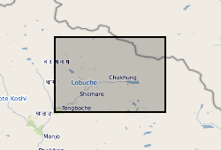
These data consist of a spreadsheet containing 557 ground control points (GCPs) collected in the Everest region of Nepal between October 2015 and October 2016. GCPs were collected using a Leica GS10 differential Global Positioning System (dGPS), post-processed against base station data at Syangboche. These final data have sub-centimetre accuracy (in x, y and z) in all cases. Point positions are heavily concentrated around meltwater ponds on the glacier surface, and prominent features around the glacier margin. These data will be used by PhD students and staff in the School of Geography, University of Leeds, to provide ground control for fine-resolution satellite imagery and Structure-from-Motion surveys to assess mass loss processes on Khumbu Glacier.
-

PROJECT DETAILS ONLY - NO DATA. Abrupt shifts in North Atlantic palaeoceanographic and ice-rafted detrital (IRD) records indicate a strong link between the meridional heat flux driven by thermohaline circulation (THC) and glacimarine discharges from the Late Pleistocene ice sheets. We propose a detailed multiple proxy investigation into ocean-ice-climate interaction in the NE Atlantic to: (i) reconstruct the variability of THC (surface and deep circulation); (ii) establish the source and timing of IRD events (geochemical and petrographic fingerprinting); (iii) generate a high-resolution chronostratigraphic framework that will allow us to (iv) sequence the interaction between North Atlantic THC, climate and ice sheet behaviour associated with Heinrich events, their precursors and D-O oscillations at centennial to interdecadal timescales.
-

PROJECT DETAILS ONLY - NO DATA. The El Nino-Southern Oscillation (ENSO) is the most potent source of interannual climate variability. Uncertainty surrounding the impact of greenhouse warming on ENSO strength and frequency has stimulated efforts to develop a better understanding of the sensitivity of ENSO to climate change. Here we use annually banded corals from Papua New Guinea to show that ENSO has existed for the past 130,000 years, operating even during "glacial" times of substantially reduced regional and global temperature and changed solar forcing. However, we also find that during the 20th century ENSO has been strong compared with ENSO of previous cool (glacial) and warm (interglacial) times. The observed pattern of change in amplitude may be due to the combined effects of ENSO dampening during cool glacial conditions and ENSO forcing by precessional orbital variations
-

The UK Geoenergy Observatories (UKGEOS) Glasgow superficial deposits GSI3D model outputs, created by the British Geological Survey, provide a semi-regional overview of the depth, thickness and extent of glacial and post-glacial lithostratigraphic units above rockhead. The model allows users to visualise the likely subsurface sequence to be found beneath this part of Glasgow, applicable at a scale of around 1: 25,000 to 1: 10,000. The data is supplied as grids and shapefiles over a 7 by 4.15 km area, with the depth range to around 40 m below Ordnance Datum. This model describes an interpretation of the shallow geology updated to incorporate the results of drilling the 12 UKGEOS Glasgow boreholes (post-drill model). Further details and model limitations can be found in the accompanying metadata report http://nora.nerc.ac.uk/id/eprint/531155/ . DOI: https://doi.org/10.5285/915f690f-32cf-41b7-984e-c32344d3a543
-

The UK Geoenergy Observatories (UKGEOS) Glasgow superficial deposits GSI3D model outputs, created by the British Geological Survey, provide a semi-regional overview of the depth, thickness and extent of glacial and post-glacial lithostratigraphic units above rockhead. The model allows users to visualise the likely subsurface sequence to be found beneath this part of Glasgow, applicable at a scale of around 1: 25,000 to 1: 10,000. The data is supplied as grids and shapefiles over a 7 by 4.15 km area, with the depth range to around 40 m below Ordnance Datum. This model describes an interpretation of the shallow geology before the UKGEOS Glasgow boreholes have been drilled, and was used to inform the expected sequence on drilling. Further details and model limitations can be found in the accompanying metadata report http://nora.nerc.ac.uk/id/eprint/524556
-
This dataset consists of measurements of cosmogenic 10Be in quartz from a set of erratic cobbles collected from the surfaces of nunataks in West Antarctica. The cobbles were collected during the 2019-20 Antarctic field season from the Hudson Mountains, which are situated adjacent to Pine Island Glacier. The dataset includes cosmogenic nuclide (10Be) exposure ages and all field (sample locations and elevations) and analytical laboratory (quartz and beryllium carrier masses, Be-10/Be-9 ratios) data for field samples and procedural blanks required to calculate the ages. Natural Environment Research Council (NERC: Grants NE/S006710/1, NE/S006753/1, and NE/S00663X/1) and National Science Foundation (NSF: Grant OPP 2317097). Australian Nuclear Science and Technology Organisation (ANSTO) Centre for Accelerator Science award AP12872, through the National Collaborative Research Infrastructure Strategy (NCRIS).
-
This dataset consists of measurements of cosmogenic 10Be in quartz from a set of 41 erratic cobbles and boulders collected from the surfaces of nunataks in West Antarctica. The erratics were collected during the 2019-20 Antarctic field season from the Hudson Mountains, which are situated immediately to the north of Pine Island Glacier. The samples in this dataset were collected from nunataks (Webber Nunatak, Mount Moses, Slusher Nunatak, Dean Nunataks, Wold Nunatak, and Siren Rock) located adjacent to Larter and Lucchitta glaciers which dissect the area. The dataset includes cosmogenic nuclide (10Be) exposure ages and all field (sample locations and elevations) and analytical laboratory (quartz and beryllium carrier masses, 10Be/9Be ratios) data for field samples and procedural blanks required to calculate the exposure ages. This project was funded by Natural Environment Research Council (NERC: Grants NE/S006710/1, NE/S006753/1, and NE/S00663X/1) and National Science Foundation (NSF: Grant OPP 2317097). Australian Nuclear Science and Technology Organisation (ANSTO) Centre for Accelerator Science award AP12872, through the National Collaborative Research Infrastructure Strategy (NCRIS).
-
This dataset consists of measurements of cosmogenic Be-10 and Al-26 in quartz for a set of cobbles collected from a moraine proximal to Mount Murphy, a nunatak located between Pope and Thwaites glaciers, West Antarctica. The cobbles were collected during the 2015-2016 Antarctic field season. The dataset includes cosmogenic nuclide (Be-10 and Al-26) surface exposure ages and all field (location, elevation, shielding, thickness) and analytical laboratory (quartz, beryllium and aluminium carrier masses, Be-10/Be-9 and Al-26/Al-27 ratios) data for field samples and procedural blanks required to calculate the ages. Funding source: Natural Environment Research Council (NERC: Grants NE/S006710/1 (JSJ), NE/K012088/1 (JSJ), NE/S006753/1 (DHR), NE/K011278/1 (DHR)). Australian Nuclear Science and Technology Organisation (ANSTO) Centre for Accelerator Science award AP12872 (DHR) through the National Collaborative Research Infrastructure Strategy (NCRIS).