 NERC Data Catalogue Service
2010
Type of resources
Available actions
Topics
Keywords
Contact for the resource
Provided by
Years
Formats
Representation types
Update frequencies
Service types
Scale
Resolution
-
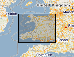
The British Geological Survey (BGS) was awarded a grant from the Welsh Assembly Government Aggregates Levy Fund in 2009 to provide a comprehensive, relevant and accessible information base to enhance the sustainability of mineral resources for Wales. BGS co-funded this project through its Sustainable Mineral Solutions project. This work was completed in 2010. This dataset comprises the digital GIS files which were produced through this project. The major elements of minerals information presented on the maps are; the geological distribution of all onshore mineral resources in Wales, the location of mineral extraction sites, the recorded occurrences of metallic minerals, the recorded location of former slate quarries and significant areas of slate waste and the recorded location of historic building stone quarries. The BGS Mineral Resource data does not determine mineral reserves and therefore does not denote potential areas of extraction. Only onshore, mainland mineral resources are included in the dataset. This dataset has been produced by the collation and interpretation of mineral resource data principally held by the British Geological Survey. The mineral resource data presented are based on the best available information, but are not comprehensive and their quality is variable. The dataset should only be used to show a broad distribution of those mineral resources which may be of current or potential economic interest. The data should not be used to determine individual planning applications or in taking decisions on the acquisition or use of a particular piece of land, although they may give useful background information which sets a specific proposal in context.
-
The RISCS (Research into Impacts and Safety in CO2 Storage) project assessed the potential environmental impacts of leakage from geological CO2 storage. Consideration was given to possible impacts on groundwater resources and on near surface ecosystems both onshore and offshore. The aim of the project was to assist storage site operators and regulators in assessing the potential impacts of leakage so that these could be considered during all phases of a storage project (project design, site characterisation, site operation, post-operation and site abandonment, and following transfer of liability back to the state). A secondary objective was to inform policy makers, politicians and the general public of the feasibility and long-term benefits and consequences of large-scale CO2 capture and storage (CCS) deployment. RISCS was a 4 year project supported by the European Commission under the 7th Framework Programme. Project website http://www.riscs-co2.eu.
-

The response of the benthic microbial community to a controlled sub-seabed CO2 leak was assessed using quantitative PCR measurements of benthic bacterial, archaeal and cyanobacteria/chloroplast 16S rRNA genes. Similarly, the impact of CO2 release on the abundance of benthic bacterial and archaeal ammonia amoA genes and transcripts, and also to the abundance of nitrite oxidizer (nirS) and anammox hydrazine oxidoreductase (hzo) genes and transcripts. Samples were taken from four zones (epicentre (zone 1); 25m distant (zone 2), 75m distant (zone 3) and 450m distant (zone 4)) during 6 time points (7 days before CO2 exposure, after 14 and 36 days of CO2 release, and 6, 20 and 90 days after the CO2 release had ended). Changes to the active community of microphytobenthos and bacteria were also assessed before, during and after CO2 release using Denaturing Gradient Gel Electrophoresis of cyanobacteria/chloroplast 16S rRNA. Changes to the composition of the active bacterial community was assessed first using Terminal Restriction Fragment Length Polymorphism (T-RFLP) of bacterial 16S rRNA. In depth comparisons of possible changes to the active bacterial community at zone 1 and 4 before, during and immediately after the CO2 release was performed using 16S rRNA 454 pyrosequencing. This dataset was created by Plymouth Marine Laboratory (PML) under the program QICS (Quantifying and monitoring environmental impacts of geological carbon storage) which was funded by the Natural Environment Research Council (NERC), with support from the Scottish Government. The results are contained in three text files. QICS project website: www.bgs.ac.uk/qics/home.html. Tait et al. (2015) Rapid response of the active microbial community to CO2 exposure from a controlled sub-seabed CO2 leak in Ardmucknish Bay (Oban, Scotland). IJGGC DOI: 10.1016/ijggc.2014.11.021. Watanabe et al. (2015) Ammonia oxidation activity of microorganisms in surface sediment to a controlled sub-seabed release of CO2. IJGGC DOI: 10.1016/j.ijggc.2014.11.013.
-

QICS (Quantifying and monitoring environmental impacts of geological carbon storage) was a program funded by the Natural Environment Research Council (NERC), with support from the Scottish Government (May 2010 - December 2014) with two objectives. Firstly, to assess if any significant environmental impact would arise, if a leak from sub-sea, deep geological storage of carbon dioxide occurred. Secondly, to test and recommend tools and strategies for monitoring for (or assuring the absence of) leakage at the sea floor and in overlying waters. This data set provides a short overview of the novel experimental procedure - a world first leakage simulation in the natural environment and describes the experimental set up, sampling strategy including both temporal and spatial details. The data set consists of a pdf containing a text based project and experimental overview, a table outlining the temporal evolution of the experiment, including site selection, set up, baseline, impact and recovery phases and a diagram outlining the spatial sampling strategy. This data set contains an overview document collated by Plymouth Marine Laboratory. This provides the context for a number of specific related QICS datasets submitted to the UKCCS data archive, covering a range of geological, chemical and ecological information. QICS project website: www.bgs.ac.uk/qics/home.html. Blackford et al., 2014. Detection and impacts of leakage from sub-seafloor deep geological carbon dioxide storage. Nature Climate Change 4, 1011-1016. DOI: 10.1038/NCLIMATE2381. Taylor et al., 2015. A novel sub-seabed CO2 release experiment informing monitoring and impact assessment for geological carbon storage. Int J Greenhouse Gas Control. DOI:10.1016/j.ijggc.2014.09.007.
-

Data identifying landscape areas (shown as polygons) attributed with type of mass movement e.g. landslip. The scale of the data is 1:10 000 scale. Onshore coverage is partial with approximately 30% of England, Scotland and Wales available in the version 2 data release. BGS intend to continue developing coverage at this scale; current focus is to include all large priority urban areas, along with road and rail transport corridors. Mass movement describes areas where deposits have moved down slope under gravity to form landslips. These landslips can affect bedrock, superficial or artificial ground. Mass movement deposits are described in the BGS Rock Classification Scheme Volume 4. However the data also includes foundered strata, where ground has collapsed due to subsidence (this is not described in the Rock Classification Scheme). Caution should be exercised with this data; historically BGS has not always recorded mass movement events and due to the dynamic nature of occurrence significant changes may have occurred since the data was released. The data are available in vector format (containing the geometry of each feature linked to a database record describing their attributes) as ESRI shapefiles and are available under BGS data licence.
-
COBRA (impact of COmbined iodine and Bromine Release on the Arctic atmosphere) is a UK IPY (International Polar Year) consortium that aims to investigate the release mechanisms of iodine in the Arctic and the potential combined effects of iodine and bromine on its atmosphere. The team measured reactive inorganic halogens (BrO, IO, OIO, I2), O3, Hg, HOx, HCHO, NOx, VOCs and reactive halocarbons from temporary laboratories located on the eastern shore of Hudson Bay, north of Kuujjuarapik, during February-March 2008. Met balloons and O3 sondes were launched daily. COBRA set up an ice camp and flux chamber experiments ~500 m into the bay to directly measure halogen emissions and ozone deposition, and measured physical, chemical and biological characteristics of the sea-ice (and potentially of frost flowers) at different depths. The project is linked with OOTI, which carried out a simultaneous field experiment at Kuujjuarapik.
-
Data from observations made at the Cape Verde Atmospheric Observatory (CVAO) which exists to advance understanding of climatically significant interactions between the atmosphere and ocean and to provide a regional focal point and long-term data. The observatory is based on Calhau Island of São Vicente, Cape Verde at 16.848N, 24.871W, in the tropical Eastern North Atlantic Ocean, a region which is data poor but plays a key role in atmosphere-ocean interactions of climate-related and biogeochemical parameters including greenhouse gases. It is an open-ocean site that is representative of a region likely to be sensitive to future climate change, and is minimally influenced by local effects and intermittent continental pollution. The dataset contains mixing ratio measurements of ethane, propane, iso-butane, acetylene and iso-pentane.
-
The overall aim of the UK Surface Ocean / Lower Atmosphere Study (UK SOLAS) is to advance understanding of environmentally significant interactions between the atmosphere and ocean, focusing on material exchanges that involve ocean productivity, atmospheric composition and climate. The knowledge obtained will improve the predictability of climate change and give insights into the distribution and fate of persistent pollutants. The dataset contains biological and chemical measurements such as: major nutrients and trace metal concentrations in aerosol and rain samples, chemical analyses of inorganic micro-nutrients, dissolved and particulate trace metal and carbon analyses, dissolved nitrogen and organic phosphate, biological measurements including phytoplankton pigments, bacteria, picoplankton and larger phytoplankton abundance.
-
The objective of the ADIENT (Appraising the Direct Impacts of aErosol oN climaTe) project was quantifying the direct effect of aerosols on the Earth's radiation budget, via scattering and/or absorption of radiation. This daily data was a subset of the GlobAEROSOL climatology from the Advanced Along Track Scanning Radiometer (AATSR) instrument on-board Envisat, data for the period 24 July 2002 to 25 February 2009. This dataset contains measurements of the following parameters over the globe: Aerosol optical thickness taken at 550nm and 870nm, Angstrom Coefficient, Earth surface albedo taken at 550nm, 670nm, 870nm, and 1600nm. Upwelling spectral radiance in the air (measured reflectance) at 550nm, 670nm, 870nm, 1600nm, and 3700nm. Brightness temperature taken at 11000nm and 12000nm. Cloud area fraction Aerosol speciation (from a selection of 5 pre-defined types:maritime, continental, desert, urban/polluted and biomass burning).
-
Data from observations made at the Cape Verde Atmospheric Observatory (CVAO) which exists to advance understanding of climatically significant interactions between the atmosphere and ocean and to provide a regional focal point and long-term data. The observatory is based on Calhau Island of São Vicente, Cape Verde at 16.848N, 24.871W, in the tropical Eastern North Atlantic Ocean, a region which is data poor but plays a key role in atmosphere-ocean interactions of climate-related and biogeochemical parameters including greenhouse gases. It is an open-ocean site that is representative of a region likely to be sensitive to future climate change, and is minimally influenced by local effects and intermittent continental pollution. The dataset contains NAME dispersion model footprints images.