 NERC Data Catalogue Service
KMZ
Type of resources
Available actions
Topics
Keywords
Contact for the resource
Provided by
Years
Formats
Representation types
Update frequencies
Scale
-

OneGeology is an international collaborative project in the field of geology supported by 113 countries, UNESCO and major global geoscience bodies. It aims to enable online access to dynamic digital geological map of the world for everyone. An EU Joint Research Centre project is using OneGeology geological data as a framework for the production of a Geogenic Radon Map of Europe. The BGS-HPA UK Onegeology Radon Potential dataset provides, within a 1:625,000 scale geological framework, a general indication of how the estimated arithmetic mean ground-floor radon concentration varies within the United Kingdom. The indoor radon data is used with the agreement of the Health Protection Agency (HPA). Mapping of radon-prone areas at the OneGeology 1:625 000 scale can be used to inform European policy makers, politicians and the general public about the general variation of radon potential within the United Kingdom at the European scale. The dataset should not be used at scales larger than 1:250,000 or for regulatory (i.e. Building Control or Radon Affected Area) purposes in the UK.
-
In 2011 the British Geological Survey (BGS) decided to begin the assembly of a National Geological Model (NGM) from its existing and on-going geological framework models , comprising integrated national crustal, bedrock and Quaternary models. The bedrock component is the most advanced of these themes and comprises both the calculated models and a complementary network of cross-sections that provide a fence diagram for the bedrock geology of Great Britain. This fence diagram, the GB3D_v2014 dataset is available in a variety of formats from the BGS website www.bgs.ac.uk as free downloads, it supercedes the earlier 2012 version. The model complements the existing 1:625 000 scale mapsheets published by BGS utilising the same colour schema and geological classification. The component cross-sections extend to depths between 1.5 and 6 km; they have an aggregate length of over 25,000 km, and they are snapped together at their intersections to ensure total consistency. The sections are based on the existing BGS geological framework models where they cut through them together and incorporate around 300 deep stratigraphic boreholes across England and Wales. The sections also take account of the vast wealth of published data on the subsurface structure of Britain both from BGS and in the scientific literature. Much of this is in the form of cross-sections, contour maps of surfaces, and thicknesses (isopachs). The fence diagram has been built in the Geological Surveying and Investigation in 3D (GSI3D) software. It is envisaged that this dataset will form a useful educational resource for geoscience students and the general public, and also provide the bedrock geology context and structure for regional and catchment scale studies. The fence diagram has been built in stages between 2009-14 using funding from the BGS National Capability Programme the Environment Agency of England and Wales, and the Nuclear Decommissioning Authority. Some 16 expert regional geologists compiled the sections.
-

In 2011 the British Geological Survey (BGS) decided to begin the assembly of a National Geological Model (NGM) from its existing and on-going geological framework models , comprising integrated national crustal, bedrock and Quaternary models. The bedrock component is the most advanced of these themes and comprises both the calculated models and a complementary network of cross-sections that provide a fence diagram for the bedrock geology of Great Britain. This fence diagram, the GB3D_v2012 dataset is available in a variety of formats from the BGS website www.bgs.ac.uk as free downloads. It complements the existing 1:625 000 scale mapsheets published by BGS utilising the same colour schema and geological classification. The 121 component cross-sections extend to depths between 1.5 and 6 km; they have an aggregate length of over 20,000 km, and they are snapped together at their intersections to ensure total consistency. The sections are based on the existing BGS geological framework models where they cut through them, they also take account of the vast wealth of published data on the subsurface structure of Britain both from BGS and in the literature. Much of this is in the form of cross-sections, contour maps of surfaces, and thicknesses (isopachs). The fence diagram has been built in the Geological Surveying and Investigation in 3D (GSI3D) software. It is envisaged that this dataset will form a useful educational resource for geoscience students and the general public, and also provide the bedrock geology context and structure for regional and catchment scale studies. The fence diagram was built in 2009-12 using funding from the BGS National Capability Programme and the Environment Agency of England and Wales. 14 expert regional geologists compiled the sections.
-
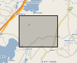
This data set characterises the seismicity occurring within 30 km of the Bora - Tullu-Moye volcanic field between 2016 and 2017. It also provides a description of key geologic features in this region. See the README file for a full explanation of the data set. These data were originally published as supplementary material in g-cubed article: Seismicity of the Bora – Tullu-Moye Volcanic field 2016-2017: Greenfield et al (2018), https://doi.org/10.1029/2018GC007648