 NERC Data Catalogue Service
Archive (ZIP)
Type of resources
Available actions
Topics
Keywords
Contact for the resource
Provided by
Years
Formats
Representation types
Update frequencies
-
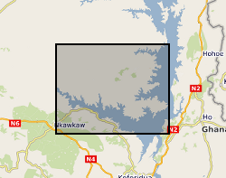
This data was produced to support a project looking at low permeability rocks in sub-Saharan Africa. Multiple boreholes were drilled for the project with geology identified from chippings. Groundwater chemistry was analysed from the resulting boreholes. The data contained within this record is from the CD that accompanies the report: J Davies and J Cobbing, 2002. An assessment of the hydrogeology of the Afram Plains, Eastern Region, Ghana. British Geological Survey Internal Report, CR/02/137N. 66pp http://nora.nerc.ac.uk/id/eprint/505607/1/CR_02_137N.pdf The CD has not been uploaded in full elsewhere.
-
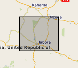
This data was produced to support a project looking at low permeability rocks in sub-Saharan Africa. Multiple boreholes were drilled for the project with geology identified from chippings. Groundwater chemistry was analysed from the resulting boreholes. The data contained within this record is from the CD that accompanies the report: J Davies and B É Ó Dochartaigh. 2002. Low Permeability Rocks In Sub-Saharan Africa. Groundwater development in the Tabora Region, Tanzania. British Geological Survey Internal Report, CR/02/191N. 71pp http://nora.nerc.ac.uk/id/eprint/505608/1/CR_02_191N.pdf The CD has not been uploaded in full elsewhere.
-

This collection includes the elastic calculations of the hcp-Fe-Si-S-C alloy system. NERC grant NE/M015181/1 - Pre melting in iron and iron alloys: ab initio calculations and high P-T experiments on iron, iron alloys and other materials
-
These files contain ground penetrating radar (GPR) data collected from the glacier margins and forelands of Falljökull and of Kvíárjökull, south-east Iceland, between 2012 and 2014. The data were collected using a Sensors and Software PulseEKKO Pro GPR system. For each glacier the data are stored in folders that indicate the month and year in which the surveys were conducted. Each GPR profile has a Sensors and Software GPR (.DT1) file, and associated header (.HD) and GPS (.GPS) files. The .HD files (which can be opened as text files) give the parameters and equipment used for each profile. GPS files are not available for some of the profiles collected on Falljökull in April 2013 (due to damage that occurred to the GPS linked with the PulseEKKO Pro system). For these profiles start, finish, and mid profile positions were recorded using differential GPS, and locations of these profiles are instead given by GIS shapefiles in the relevant folders. These datasets have been used in the publications listed below. Further information relating to the data collection methodology can be found therein. Phillips, Emrys; Everest, Jez; Evans, David J.A.; Finlayson, Andrew; Ewertowski, Marek; Guild, Ailsa; Jones, Lee. 2017 Concentrated, ‘pulsed’ axial glacier flow: structural glaciological evidence from Kvíárjökull in SE Iceland. Earth Surface Processes and Landforms, 42 (13). 1901-1922. https://doi.org/10.1002/esp.4145 Phillips, Emrys; Finlayson, Andrew; Bradwell, Tom; Everest, Jez; Jones, Lee. 2014 Structural evolution triggers a dynamic reduction in active glacier length during rapid retreat: evidence from Falljökull, SE Iceland. Journal of Geophysical Research: Earth Surface, 119 (10). 2194-2208. https://doi.org/10.1002/2014JF003165 Phillips, Emrys; Finlayson, Andrew; Jones, Lee. 2013 Fracturing, block-faulting and moulin development associated with progressive collapse and retreat of a polar maritime glacier: Virkisjokul-Falljokull, SE Iceland. Journal of Geophysical Research: Earth Surface, 118 (3). 1545-1561. https://doi.org/10.1002/jgrf.20116 Flett, Verity; Maurice, Louise; Finlayson, Andrew; Black, Andrew; MacDonald, Alan; Everest, Jez; Kirkbride, Martin. 2017. Meltwater flow through a rapidly deglaciating glacier and foreland catchment system: Virkisjökull, SE Iceland. Hydrology Research, 48 (6). 1666-1681. https://doi.org/10.2166/nh.2017.205
-
A number of processes, both natural and anthropogenic, involve the fracture of rocks subjected to tensile stress, including vein growth and mineralization, and the extraction of hydrocarbons through hydraulic fracturing. In each case, the fundamental material property of mode-I fracture toughness must be overcome in order for a tensile fracture to nucleate and propagate. Whilst measuring this parameter is straightforward at ambient pressure, estimating the fracture toughness of rocks at depth, where they experience a confining pressure, is technically challenging. Here, we report a new analysis combining results from standard thick-walled cylinder burst tests with quantitative acoustic emission to estimate the mode-I fracture toughness (KIc) of Nash Point Shale at elevated confining pressure, simulating in-situ conditions to approximately 1km. In the most favorable orientation, the pressure required to fracture the rock shell (injection pressure, Pinj) increases from 6.1 MPa at 2.2 MPa confining pressure (PC), to 34 MPa at 20 MPa confining pressure. When fractures cross the shale bedding, the required injection pressures are 30.3 MPa (at Pc = 4.5 MPa) and 58 MPa (at Pc = 20 MPa), respectively. Applying the model of Abou-Sayed (1978) to estimate initial flaw size, we calculate that this pressure increase equates to an increase in KIc from 0.6 MPa.m1/2 at 3.2 MPa differential pressure (Pinj - PC) to 4.1 MPa.m1/2 at 22 MPa differential pressure. We conclude that the increasing pressure due to depth in the Earth will have a significant influence on fracture toughness, which is also a function of the inherent anisotropy.
-
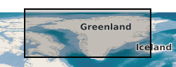
These high resolution high-oblique time-lapse images were collected in hourly intervals from 5 locations around Helheim glacier in SE Greenland in the summer of 2013. Three cameras (Cameras 1, 2 and 3) were aimed at the calving front ~3.5 km down glacier from the calving front and two cameras (Cameras 4 and 5) were aimed cross-glacier ~3 km up glacier from the calving front. The images are in two stereo groups allowing the extraction of 3D data with significant processing though there are some optical issues that will degrade quality. Links to Published Papers: 1, Extensive Retreat of Greenland Tidewater Glaciers 2000-2010. http://dx.doi.org/10.1657/AAAR0014-049 2, Dynamics of glacier calving at the ungrounded margin of Helheim Glacier South East Greenland. http://dx.doi.org/10.1002/2015JF003531 3, Reverse Glacier motion during Iceberg calving and the cause of Glacial Earthquakes. http://dx.doi.org/10.1126/science.aab0460. 5, A High-resolution Sensor Network for Monitoring Glacier Dynamics. http://dx.doi.org/10.1109/JSEN.2014.2348534. , On the Role of Buoyant Flexure in Glacier Calving. 6, Buoyant Flexure controls summer dynamic mass loss at Helheim Glacier Greenland
-
The dataset comprise hydrogeochemical, isotopic and environmental geophysics data from surface waters and groundwater and sediments from scientific boreholes drilled into arsenic-prone aquifers in the Mekong River Basin. The data is divided into 5 categories: Geophysical data Hydrogeochemical data Isotopic data Sedimentary data Outreach and Dissemination Publications to date - open access linkages The data pertain to samples obtained from northern Kandal province just south of Phnom Penh in Cambodia. The data were collected over the period 2013-2016. The hydrogeochemical data were obtained by one of more of (i) in situ analytical techniques; or (ii) instrumental geochemical techniques, notably IC, ICP-AES, ICP-MS and GC-MS in the Manchester Analytical Geochemistry Unit, University of Manchester following methods as described in Richards et al. (2015, 2017). The geophysical data were obtained as described in Uhlemann et al. (2017). The data were obtained as part of a project funded by NERC Standard Research Grant NE/J023833/1 the major purpose of which was to determine the extent to which surface derived organics may be driving arsenic mobilisation in shallow circum-Himalayan aquifers, an exemplar of which is norther Kandal Province's largely Holocene aquifers to which these data refer. The data were obtained and interpreted by the University of Manchester except as follows: environmental geophysics data were obtained and interpreted by Oliver Kuras and Sebastian Uhlemann of the British Geological Survey GTOM team; tritium data were generated by Jurgen Sultenfuss of the University of Bremen; oxygen and hydrogen isotope data by SUERC, East Kilbride and carbon-14 data by the NERC Radiocarbon Laboratory at East Kilbride.
-

Data associated with the UKCCSRC thermal oxygen project - UKCCSRC-1-39, including rig design, reactor and burner design diagrams, heat transfer calculations for thermal oxygen, CuO-AI2O3 particles preparation procedure document, etc. Data is restricted.