 NERC Data Catalogue Service
Archive (TAR)
Type of resources
Available actions
Topics
Keywords
Contact for the resource
Provided by
Years
Formats
Representation types
Update frequencies
-
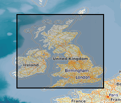
This is a thin-sheet model of the regional geoelectric field covering the UK and Ireland, which is a combination of the response of the ground conductivity in a region with the spatial and temporal measurements of the rate of change of the horizontal components of the magnetic field. Output from the BGS Space Weather Impact on Ground-based Systems (SWIGS)
-
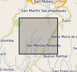
Continuous seismic waveforms from a network deployed at Santiaguito volcano between 2014 and 2015. Data are collected on broadband and short-period seismometers to record all volcanic activity for the period. Recorded data includes explosions, rockfalls and regional earthquakes.
-

3-D P-wave velocity model of the crust and uppermost mantle beneath Macquarie Island and surrounding region from teleseismic tomography. The dataset contains data and files that can be used to plot the teleseismic tomography model that was produced from broadband seismic data collected as part of the Macquarie Ridge experiment undertaken in 2020-2021 (NERC grant NE/T000082/1). The model region approximately spans 53° - 56° South and 157° - 160.5° East. The data can be accessed from the AusPass data portal at https://auspass.edu.au/networks/macquarieridge.html. The information contained in this repository can be used to plot or otherwise use this model for other purposes. The dataset includes a detailed description of the format in a README file.