 NERC Data Catalogue Service
Bathymetry
Type of resources
Available actions
Topics
Keywords
Contact for the resource
Provided by
Years
Formats
Representation types
Update frequencies
Service types
Scale
-
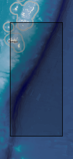
The Tonga Trench was surveyed with a Kongsberg EM 124 gondola-mounted to the hull of the 225-foot DSSV Pressure Drop. The survey was conducted over the course of two weeks – May 29 – June 6, 2019. The data meet the requirements for IHO Special Order standards.
-
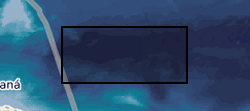
The Brownson Deep area of the Puerto Rico Trench was surveyed with a Kongsberg EM 124 gondola-mounted to the hull of the 225-foot DSSV Pressure Drop. The survey was conducted over the course of two days – December 18-19, 2018. The data meet the requirements for IHO Special Order standards.
-

The Java Trench was surveyed with a Kongsberg EM 124 gondola-mounted to the hull of the 225-foot DSSV Pressure Drop. The survey was conducted over the course of two weeks – March 26th – April 9th, 2019. The data meet the requirements for IHO Special Order standards.
-

The Mariana Trench was surveyed with a Kongsberg EM 124 gondola-mounted to the hull of the 225-foot DSSV Pressure Drop. The survey was conducted over the course of two weeks – April 19th – May 6th, 2019. The data meet the requirements for IHO Special Order standards.
-
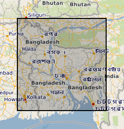
This dataset contains data from a river multibeam and seismic survey which took place in 2013 and 2014 at scour sites within the Brahmaputra river basin in Bangladesh. The survey was carried out as part of a joint project between the Universities of Birmingham, Southampton and Exeter. "The sedimentology of fluvial megascours" was a scientific research project funded by NERC. The purpose was to collect the data necessary to validate the first generic numerical model of scour zone stratigraphy that will be widely applicable to a broad range of large rivers. River bed bathymetry data were collected using a multibeam echosounder. Sub bottom seismic profiling data were collected using a surface tow boomer and chirp system. Technical details of the survey are contained in the cruise report of the survey which comprises part of the metadata. Some of the data has been accepted for a publication in the journal 'Sedimentology' which will be published in 2018 with the title 'The Sedimentology of channel confluences'.
-

The Dordrecht Deep, the deepest section of the Diamantina Fracture Zone (Indian Ocean), was surveyed with a Kongsberg EM 124 gondola-mounted to the hull of the 225-foot DSSV Pressure Drop. The survey was conducted over the course of three days – March 12-15, 2019. The data meet the requirements for IHO Special Order standards.
-

Digitally held Seabed Sediment, Facies, Bathymetry, Solid and Quaternary offshore geology for certain areas in the UK inshore waters. The storage formats of the data are ESRI and MapInfo but other formats can be supplied.
-

3-D P-wave velocity model of the crust and uppermost mantle beneath Macquarie Island and surrounding region from teleseismic tomography. The dataset contains data and files that can be used to plot the teleseismic tomography model that was produced from broadband seismic data collected as part of the Macquarie Ridge experiment undertaken in 2020-2021 (NERC grant NE/T000082/1). The model region approximately spans 53° - 56° South and 157° - 160.5° East. The data can be accessed from the AusPass data portal at https://auspass.edu.au/networks/macquarieridge.html. The information contained in this repository can be used to plot or otherwise use this model for other purposes. The dataset includes a detailed description of the format in a README file.
-
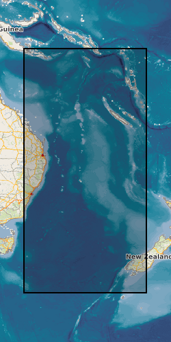
These data are derived from a voyage on Australia’s R/V Investigator, IN2019_v04, ‘Hotspot dynamics in the Coral Sea: connections between the Australian plate and the deep Earth’. The voyage surveyed the Tasmantid and Lord Howe Seamounts in the Tasman and Coral Seas, together with the Louisiade Plateau in the Coral Sea, sailing from Cairns on 7 Aug 2019 and arriving in Brisbane on 3 Sep 2019. The voyage summary is available at https://www.marine.csiro.au/data/reporting/get_file.cfm?eov_pub_id=1443. This directory includes the ship data, in some cases with initial onshore processing done by CSIRO technical staff (e.g., the underway data). More details are available in the README file.
-
Data from Marine Conservation Zone (MCZ) surveys are archived in the MEDIN Data Archive Centre (DAC) for Geology and Geophysics at the British Geological Survey. This includes geology (Particle Size Analysis) data and multibeam backscatter data. Data are delivered via the BGS Offshore GeoIndex. Additional data are available on request enquiries@bgs.ac.uk. Other data types are archived with the other MEDIN DACs as appropriate (UKHO DAC for bathymetry data and DASSH DAC for biological data). https://www.gov.uk/government/collections/marine-conservation-zone-designations-in-england.