 NERC Data Catalogue Service
Conductivity
Type of resources
Available actions
Topics
Keywords
Contact for the resource
Provided by
Years
Formats
Update frequencies
-

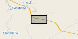
The data set provides climate and cave monitoring data from Cueva de Asiul, Cantabria, northern Spain. This data was initially presented in graphical form in Smith et al., (2015) - Drip water Electrical Conductivity as an indicator of cave ventilation at the event scale. Science of the Total Environment, 532, 517-527. All data was collected from within the cave or within a 1km radius of the cave site (43°19'0"N, 3°35'28"W) using instrumentation set up as part of a PhD project running between January 2010 and January 2014. The data set includes high resolution event based monitoring data for a range of climatic parameters - cave and external temperature, rainfall amount, soil pCO2 cave air pCO2 concentration, cave drip water calcium saturation, drip water electrical conductivity and cave air pressure. This data was analysed at Lancaster University, UK or at the NERC isotope geosciences laboratory, British Geological Survey, UK. Any missing data from this 4 year period is a result of instrument malfunction and is clearly explained within the above cited paper. The electrical conductivity component of the data set offers the first data set of this type form any cave system, using a submerged CTD Diver probe and novel piston flow housing. The rest of the data constitute a part of a larger cave monitoring data set produced during the project using a number of standard automated cave monitoring devices. When combined this data leads us to conclude that cave drip water electrical conductivity is driven primarily by changes in cave air pCO2 at Cueva de Asiul and therefore responds to cave ventilation dynamics, rather than by changes in karst water residence time. Without such extremely high resolution monitoring the impact of cave ventilation on event based changes in drip water electrical conductivity would not have been established for this site. This data set should be of interest to anyone studying similar cave sites, interested in the role of electrical conductivity as a monitoring tool within caves and cave ventilation on speleothem growth dynamics. The data set was collected by members of Lancaster University and the Matienzo caving expedition as part of NERC studentship grant NE/I527953/1. All cave monitoring was undertaken with kind permission from Gobierno de Cantabria, Cultura.
-

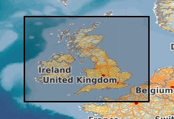
The data set contains the timeseries of long-period magnetotelluric data collected at 44 sites in Great Britain during the SWIMMR-SAGE project 2021-2023. At each site, five channels were recorded with a 1s sampling rate: The magnetic field components (north-south Bx, east-west By, and the vertical component Bz) were measured using a fluxgate magnetometer manufactured from Lemi, Lviv, Ukraine. The horizontal electric field (north-south Ex, east-west Ey) was recorded using non-polarizable electrodes. The installations were performed by BGS staff following the manufacturers guidelines and best practices. For each site, a folder containing the timeseries data and a pdf containing all relevant metadata are provided. Format: YYYY-MM-DD HH:MM:SS BX BY BZ EX EY Magnetic values in units of nT (10^-9 T). Electric field values are in mV/km. A BGS open report has been published on the NERC Open Research Archive (NORA) describing the motivation, site selection and data collection. It is referenced in the metadata and can be found here: https://nora.nerc.ac.uk/id/eprint/537960/
-

The following dataset provides climate and cave monitoring data from Cueva de Asiul northern Spain between 2010 and 2014. This data set was initially presented in Smith et al., (2016) Cave monitoring and the potential for palaeoclimate reconstruction from Cueva de Asiul, Cantabria (N. Spain). International Journal of Speleology, 45(1), 1-9. This data set represents the majority of cave monitoring undertaken at this site as part of a NERC funded PhD project (NERC studentship grant NE/I527953/1), data collection either occurred within this single cave site (43°19’0’’N, 3°35’28’’W) or within 1km of the cave in the village of Matienzo. The data set includes high resolution monitoring data for a range of climatic parameters including, cave and external temperature, rainfall direction, amount and oxygen isotope value, soil and cave air pCO2 concentration and carbon isotope value, cave drip rates and oxygen and deuterium isotope values. All data was collected using standard automated logging systems and the data/ samples were analysed either at Lancaster University, UK or at the NERC isotope geosciences laboratory, British Geological Survey, UK. Any missing data is a result of automated logger malfunction and is explained in full in the above cited paper. In combination this data offers a very high resolution, multiyear veiw into hydrological and cave ventilation processes, each of which play a major role in controlling speleothem growth and chemical makeup in Cueva de Asiul. The data set presents the pertinent background monitoring for the accurate interpretation of speleothems from this cave site. Those who may be interested in the data set include cave scientists who wish to implement a monitoring station/understand how climatic parameters influence speleothem development, or those who wish to obtain focused climate data from the Matienzo region between 2010 and 2014. The data set was collected by members of Lancaster University and the Matienzo caving expedition as part of NERC studentship grant NE/I527953/1. All cave monitoring was undertaken with kind permission from Gobierno de Cantabria, Cultura.
-
Groundwater level and groundwater temperature data measured in 9 boreholes between August 2012 and August 2018. Groundwater conductivity data measured in 1 of these boreholes from September 2012 to August 2014. Eight of the boreholes are drilled into a sandur (glacial outwash floodplain) aquifer in front of Virkisjokull glacier, SE Iceland, and are between 8.2 and 14.9 m deep. The remaining borehole is drilled into a volcanic rock aquifer between the sandur and glacier and is 5.1 m deep. Selected groundwater monitoring data are reported in Ó Dochartaigh, B. É., et al. 2019. Groundwater?- glacier?meltwater interaction in proglacial aquifers, Hydrol. Earth Syst. Sci. https://doi.org/10.5194/hess-2019-120. Further information on borehole installations and geology can be found in Ó Dochartaigh et al. 2012. Groundwater investigations at Virkisjokull, Iceland: data report 2012. British Geological Survey Open Report OR/12/088, http://nora.nerc.ac.uk/id/eprint/500570/
-
The dataset contains results of field measurements (temperature, pH, conductivity, redox potential, oxygen content) of groundwater and samples collection details as well as the results of laboratory analysis of the set of dissolved and gaseous parameters performed within the environmental monitoring campaign on 3 Polish shale gas sites where exploration activities including hydraulic fracturing were conducted in 2010-2016 period.
-
Data used to create the model outputs for NERC Grant NE/J004693/1, Geophysical Modelling of Geomagnetically Induced Currents in the UK. Data and code required to recreate results in the following papers: Beggan, C. (2015), Sensitivity of Geomagnetically Induced Currents to Varying Auroral Electrojet and Conductivity models, Earth Planets and Space, 67 (1), doi:10.1186/s40623-014-0168-9. http://nora.nerc.ac.uk/509877/ Beggan, C., Beamish, D., Kelly, G.S., Richards, A., and A. W. P. Thomson (2013), Prediction of Geomagnetically Induced Currents in the United Kingdom's National Grid, Space Weather, 11, doi: 10.1002/swe.20065. http://nora.nerc.ac.uk/502627/ Pulkkinen, A., Bernabeu, E., Eichner, J., Beggan C., and A. Thomson (2012), Generation of 100-year geomagnetically induced current scenarios, Space Weather, Vol. 10, No. 4, S04003, doi:10.1029/2011SW000750 Geological areas - United Kingdom, Ireland, North Sea