 NERC Data Catalogue Service
Coastal features
Type of resources
Available actions
Topics
Keywords
Contact for the resource
Provided by
Years
Formats
Representation types
Update frequencies
Scale
-
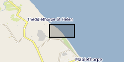
The dataset contains on-average monthly terrestrial LiDAR surveys conducted on the Lincolnshire coastline following the 2013 storm surge, collected between December 2013 and April 2015. The approximate coordinate locations of the surveys are given as follows: -EmbryoDunes (ED) 53°22'03"N 0°14'54"E -MablethorpeNorthEnd (MNE) 53°21'43"N 0°15'03"E The data were collected to record the rate and nature of recovery of the geomorphology of the back-beach and foredune zones following a storm surge in December 2013. Users interested in nearshore coastal geomorphology dynamics will find the data useful.
-
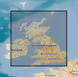
The BGS GeoCoast Dataset is a Geographic Information System (GIS)-based analysis for indicating multi-hazards and interdependencies within the coastal zone of Great Britain (not including Orkney and Shetland). GeoCoast represents the natural geological coastline (around the mainland of Great Britain) as if no coastal defences or made ground are present. This will be of particular value in areas where coastal defences are no longer maintained. GeoCoast will offer anyone with assets, or an interest in the coastline around Great Britain, access to easy-to-use datasets linked to geohazard data. This will allow users to interpret potential interdependencies in terms of erosion, flooding, habitat and other vulnerabilities. The data is delivered in GIS ESRI point, polyline and polygon format (other formats available on request).