 NERC Data Catalogue Service
Beaches
Type of resources
Available actions
Topics
Keywords
Contact for the resource
Provided by
Years
Formats
Update frequencies
-

This dataset includes raw point cloud data from repeat terrestrial laser scans (TLS) for measuring saltation and moisture dynamics as well as early-stage protodunes developing on a moist beach surface. As well as the TLS data, additional measurements include wind speed with a CSAT 3D sonic anemometer and sediment transport using a Sensit and Wenglor fork sensors. Sediment traps were also used for sediment transport, and grain size of the trapped sand was measured.
-
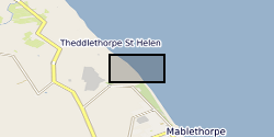
The dataset contains on-average monthly terrestrial LiDAR surveys conducted on the Lincolnshire coastline following the 2013 storm surge, collected between December 2013 and April 2015. The approximate coordinate locations of the surveys are given as follows: -EmbryoDunes (ED) 53°22'03"N 0°14'54"E -MablethorpeNorthEnd (MNE) 53°21'43"N 0°15'03"E The data were collected to record the rate and nature of recovery of the geomorphology of the back-beach and foredune zones following a storm surge in December 2013. Users interested in nearshore coastal geomorphology dynamics will find the data useful.
-

This dataset includes raw point cloud data from repeat terrestrial laser scans (TLS) for measuring early-stage protodunes developing, migrating and eroding on a moist surface in the Medano Creek Area, Great Sand Dunes National Park and Preserve, Colorado, USA. As well as the TLS data, additional measurements include wind speed with a CSAT 3D sonic anemometer and sediment transport using a Sensit and Wenglor fork sensors.