 NERC Data Catalogue Service
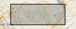
Sample Locations for Thermochronometric Analysis of Recent deformation across the Basin and Range (NERC Grant NE/N015479/1)
Locations of samples collected to constrain the recent activity on normal faults across Nevada. The geological samples will be used to measure the amount of exhumation that different normal faults of the Basin and Range experienced over the last 5 million years. The samples have been collected from granitic rocks that are expected to yield apatite crystals. (Uranium-Thorium)/Helium thermochronometry will be conducted on these samples to determine the cooling history of rocks from temperatures of approximately 70 degrees celsius. The samples are collected across Nevada at locations close to the fault to determine the most recent stages of exhumation. The ranges sampled are the Wassuk Range, White Range, Toiyabe Range, South Egan Range, Schell Range, Wheeler Range, House Range, Wasatch, Deep Greek, Ruby Range, Cortez Range, Humbolt Range, Dixie Valley, and Carson Range. Samples weigh approximately 2kg each. This sample coverage will constrain extension rates across the Basin and Range which is of interest to geologists, geodynamicists, and researchers interested in fault hazard.
Simple
- Date (Creation)
- 2020-08-03
Principal investigator
University College London
-
Matthew Fox
(
Earth Sciences
)
London
,
WC1E 6BT
,
- Maintenance and update frequency
- notApplicable notApplicable
- GEMET - INSPIRE themes, version 1.0
- BGS Thesaurus of Geosciences
-
- Faulting
- Basin range structure
- Thermochronology
- Geology
- Tectonics
- dataCentre
- Keywords
-
- NERC_DDC
- Access constraints
- otherRestrictions Other restrictions
- Other constraints
- licenceOGL
- Use constraints
- otherRestrictions Other restrictions
- Other constraints
- The copyright of materials derived from the British Geological Survey's work is vested in the Natural Environment Research Council [NERC]. No part of this work may be reproduced or transmitted in any form or by any means, or stored in a retrieval system of any nature, without the prior permission of the copyright holder, via the BGS Intellectual Property Rights Manager. Use by customers of information provided by the BGS, is at the customer's own risk. In view of the disparate sources of information at BGS's disposal, including such material donated to BGS, that BGS accepts in good faith as being accurate, the Natural Environment Research Council (NERC) gives no warranty, expressed or implied, as to the quality or accuracy of the information supplied, or to the information's suitability for any use. NERC/BGS accepts no liability whatever in respect of loss, damage, injury or other occurence however caused.
- Other constraints
- Available under the Open Government Licence subject to the following acknowledgement accompanying the reproduced NERC materials "Contains NERC materials ©NERC [year]"
- Spatial representation type
- textTable Text, table
- Metadata language
- EnglishEnglish
- Topic category
-
- Geoscientific information
- Geographic identifier
-
NEVADA [id=796000]
- Date (Creation)
- 1979
N
S
E
W
))
- Begin date
- 2019-09-23
- End date
- 2019-10-20
- Unique resource identifier
- WGS 84 (EPSG::4326)
- Distribution format
-
-
Text file (TXT)
()
-
Text file (TXT)
()
- OnLine resource
- Data ( WWW:DOWNLOAD-1.0-http--download )
- Hierarchy level
- dataset Dataset
- Other
- dataset
Conformance result
- Date (Publication)
- 2011
- Explanation
- See the referenced specification
- Pass
- No
Conformance result
- Date (Publication)
- 2010-12-08
- Explanation
- See http://eur-lex.europa.eu/LexUriServ/LexUriServ.do?uri=OJ:L:2010:323:0011:0102:EN:PDF
- Pass
- No
- Statement
- The locations of sampling sites were selected based on preliminary modeling to determine which locations will reveal the most about recent deformation. Samples were collected by driving to the footwall of normal faults and hiking to locations that contained granitic rocks suitable for sampling. The samples were stored in plastic bags and securely sealed with duck tape. They were transported back to the UK in hold luggage. The samples are in the process of being crushed so that grains of apatite can be extracted from the granite.
- File identifier
- acac2c84-5087-24c7-e054-002128a47908 XML
- Metadata language
- EnglishEnglish
- Hierarchy level
- dataset Dataset
- Date stamp
- 2026-05-06
- Metadata standard name
- UK GEMINI
- Metadata standard version
- 2.3
Point of contact
British Geological Survey
Environmental Science Centre,Keyworth
,
NOTTINGHAM
,
NOTTINGHAMSHIRE
,
NG12 5GG
,
United Kingdom
+44 115 936 3100
- Dataset URI
- http://data.bgs.ac.uk/id/dataHolding/13607652
Overviews
Spatial extent
N
S
E
W
Provided by

Associated resources
Not available