 NERC Data Catalogue Service
csv
Type of resources
Topics
Keywords
Contact for the resource
Provided by
Years
Formats
Representation types
Update frequencies
-
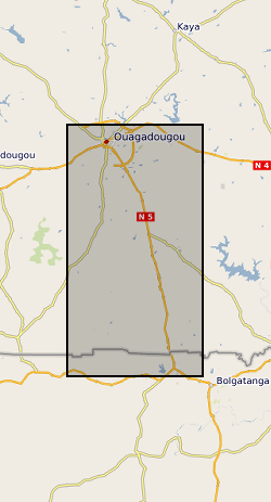
The datasets consist of soil moisture (hourly-weekly), river stage (1 min), and groundwater level (hourly) collected as part of the BRAVE project (NE/M008827/1 and NE/M008983/1) to understand the resilience of boreholes in low-yielding aquifers in the River Volta Basin to climate. The data were collected from physical observatories in Sanon (Burkina Faso) and Aniabisi (Ghana). Soil moisture data were logged hourly beneath contrasting land uses and roaming soil moisture surveys were also undertaken across a wider access tube array. River stage was monitored at the catchment outlet in Sanon and groundwater levels were measured in both catchments.
-

The measurements and data were obtained to study the release of carbon dioxide during the chemical weathering of sedimentary rocks, and how these CO2 fluxes were related to environmental parameters (temperature, hydrology). Weathering of sedimentary rocks can result in CO2 release from the oxidation of rock organic carbon oxidation, but also due to the oxidation of sulfide minerals, production of sulfuric acid and subsequent release of CO2 from carbonate minerals. The rock-derived carbon sources are understudied, and form an important part of the geological carbon cycle. The CO2 flux measurements were made on 5 rock chambers (H4, H6, H7, H8 and H13) installed in the Draix-Bleone Critical Zone Observatory, France, on outcrops of Jurassic marls. Measurements and data were collected from December 2016 to May 2019. Regular visits to the site (~4 per year) returned data on total CO2 flux (Total-CO2-flux.csv). This was explored as a function of temperature and ambient hydroclimate (precipitation). The datasets include the total CO2 flux measured at each visit to a chamber, and measurements of the internal chamber temperature. To determine the source of CO2 measured in the chambers, we trapped the CO2 using zeolite sieves and recovered it in the laboratory. The radiocarbon activity (reported as fraction modern, F14C) and its stable isotope composition (d13C) were measured from CO2 collected from chambers H4 and H6 over the sampling period (Radiocarbon-data.csv). These were used in a mixing analysis to partition the source of CO2 using a mixing model approach (Partitioned-CO2-fluxes.csv) as explained in full in the published paper Soulet et al., 2021, Nature Geoscience. We also measured the geochemical characteristics of the bedrocks being measured (rock-geochemical-composition.csv), including the organic carbon concentration, inorganic carbon concentration and their isotopic composition. Finally, we measured environmental variables of interest - the chamber temperature and the air temperature at the Draix-Bleone observatory (chamber-temperature.csv and Air-temperature-at-laval-le-plateau-weather-station.csv, respectively). This research was funded by a European Research Council Starting Grant to Robert Hilton (ROC-CO2 project, grant 678779) and radiocarbon and stable isotope measurements were funded by the Natural Environment Research Council (NERC), UK, (NERC Environmental Isotope Facility NEIF Radiocarbon Allocation 2074.1017) to Guillaume Soulet, Robert Hilton and Mark Garnett. Full details of data analysis and interpretation can be found in Soulet et al., 2021, Temperature control on CO2 emissions from the weathering of sedimentary rocks, Nature Geoscience
-
Electronic Supplementary Material: "Event trees and epistemic uncertainty in long-term volcanic hazard assessment of rift volcanoes: the example of Aluto (Central Ethiopia)", by Tierz, P., Clarke, B., Calder, E. S., Dessalegn, F., Lewi, E., Yirgu, G., Fontijn, K., Crummy, J. M., and Loughlin, S. C., submitted to Geochemistry, Geophysics, Geosystems. The datasets contain volcanological data on analogue (i.e. similar) volcanoes of Aluto volcano (Ethiopia), including conditional probabilities of eruption size, number of eruptions with specific volcanic phenomena reported and values of volcano analogy calculated using the VOLCano ANalogues Search tool (VOLCANS, Tierz et al., 2019, https://doi.org/10.1007/s00445-019-1336-3). These type of data can be used to parameterise event tree models (e.g. Newhall and Hoblitt, 2002, https://doi.org/10.1007/s004450100173; Marzocchi et al., 2010, https://doi.org/10.1007/s00445-010-0357-8) and, thus, quantify volcanic hazard at a particular volcano of interest, including the relevant sources of uncertainty. The production of the datasets was supported by the UK Natural Environment Research Council project: Rift Volcanism: Past, Present and Future (RiftVolc). Grant NE/L013460/1.
-

Surface level measurements of the Erebus volcano lava lake, Antarctica. Surface level was measured from a site at the crater rim using the Eredar radar system, a ground-based X-band FMCW radar (described in detail here: https://doi.org/10.1029/2018GL079177). The dataset contains a single continuous measurement period from 2016 (all times in UTC): 19 Dec 00:35 -> 19 Dec 19:21 Measurements were taken at a rate of ~0.25 Hz, using a 0.16 s 400 MHz bandwidth Linear Frequency Modulated chirp centred at 10.4 GHz, with 10 chirps being averaged for each measurement.
-

Oxygen and carbon isotope ratios (δ18O, δ13C) were measured on 10 to 12 shells of mixed-layer dwelling species Globigerinoides subquadratus from the 250 to 315 μm size fraction from 425 meters composite depth (mcd) until its extinction at 390 mcd. Analyses then continue with Globigerinoides spp. until 350 mcd. In a few samples, where foraminiferal density was low, only 5–7 specimens were analyzed. Analyses were made with a VG Optima mass spectrometer with multi prep device at the British Geological Survey, Keyworth, UK. When picking shells, care was taken to exclude individuals with broken or missing chambers, although preservation of specimens was generally excellent (Fox & Wade, 2013). The external reproducibility of our measurements is ±0.07‰ and ±0.05‰ for δ18O and δ13C respectively. To examine the reproducibility of the results, duplicate measurements were made on 35 samples (5%), which indicate mean reproducibility better than ±0.12‰ and ±0.14‰ for δ18O and δ13C, respectively. Oxygen isotope data are reported as per mil on the VPDB scale (Table S1) calibrated through laboratory and international standards. At ODP Site 1146, δ18O and δ13C were measured by Holbourn et al., (2010) on the mixed-layer dwelling planktonic foraminifera Globigerinoides obliquus or Gs. subquadratus, using 10 to 20 well-preserved tests from the size fraction 250-350 μm. Paired measurements in 51 samples indicate no significant offset in δ18O and δ13C between Gs. obliquus and Gs. subquadratus. Detailed methods are outlined in Holbourn et al., (2010). δ13C data are not used here. For Mg/Ca analyses, we selected 25–35 specimens of Trilobatus quadrilobatus (140–550 μg) from the 250 to 315 μm size fraction; the same size fraction as used for δ18O analysis, to minimize size-related intraspecific elemental variation (Elderfield et al., 2002). Analyses were performed on 86 samples over the studied interval. The tests were gently crushed and subsequently cleaned according to the protocol of Martin & Lea (2002) to remove clays. Cleaning included a reductive step with hydrazine to remove Mn-(hydr)oxides. Samples were measured on an ICP-AES device at Christian-Albrechts-Universität zu Kiel, Germany. Analytical precision is ~1.1%, based on measurements of an internal laboratory standard. Replicate Mg/Ca measurements revealed an average standard deviation of ~0.08 mmol/mol. Adequate cleaning is indicated by very low Fe/Ca, Al/Ca and Mn/Ca ratios.
-

Data were collected on olivine hosted melt inclusions from four Icelandic eruptions: Stapafell, Haleyjabunga, Berserkjahraun and Heilagsdalsfjall. These data were released as part of the paper "The global melt inclusion C/Ba array: Mantle variability, melting process, or degassing?", published in Geochimica et Cosmochimica Acta, with doi: 10.1016/j.gca.2020.09.030. The data collected to place new constraints on the volatile content of the Icelandic mantle source. The data include measurement of C and H by Secondary Ion Mass Spectrometry, lithophile trace elements (including Ba and Nb) by Secondary Ion Mass Spectrometry, and measurement of major element composition of the melt inclusions and their olivine hosts by Electron Probe Microanalysis. The data were collected in 2017-2018, between Edinburgh (NERC ion probe facility) and Cambridge (EPMA).
-
This dataset contains a catalogue of in-situ models for a fault activated by hydraulic fracturing in the Horn River Basin in July 2011. These were created as a part of Kettlety et al. (2019), wherein a Monte Carlo analysis was used to assess fault stability. See attached readme file for more details.
-

Ensemble of simulated groundwater levels for Iloilo, Philippines. The simulated time series of data covers the period December 1979 to December 2089 under two Representative Concentration Pathways (RCP2.6 and RCP 8.5). Each ensemble member csv file contains a timeseries of groundwater levels for thirteen locations within the Iloilo region. The textfile included in the folder shows the coordinates for these locations.
-
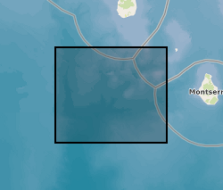
Earthquake hypocenters for all earthquakes detected on Montserrat by the Montserrat Volcano Observatory seismic network from July 1995 to February 2018 inclusive. Information includes: Origin Time, Latitude, Longitude, Depth, Hypocenter Errors, RMS and the number of stations used for each location.
-

Surface level measurements of the Halema'uma'u lava lake, Hawaii. Surface level was measured from a site at the crater rim (19.40452 N 155.27944 W 1125 M a.s.l) using the Eredar radar system, a ground-based X-band FMCW radar (described in detail here: https://doi.org/10.1029/2018GL079177). Due to technical problems, the radar did not acquire continuously throughout its deployment. The dataset contains three blocks of successful continuous measurement periods (all times in UTC): 10 Jan 22:18 -> 11 Jan 08:46 11 Jan 21:24 -> 12 Jan 22:49 14 Jan 20:27 -> 14 Jan 23:01 Measurements were taken at a rate of ~1 Hz, using a 20 ms 400 MHz bandwidth Linear Frequency Modulated chirp centred at 10.25 GHz.