 NERC Data Catalogue Service
Reefs
Type of resources
Topics
Keywords
Contact for the resource
Provided by
Years
Formats
Representation types
Update frequencies
Scale
-
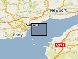
MEDIN Data. Within the project (WFA-CPC EMFF Protecting Our Seas), benthic and geophysical surveys were undertaken in the Severn Esturary/Môr Hafren SAC to explore the location of Sabellaria alveolata reefs, and collected bathymetry, sidescan sonar, AGDS and acoustic imagery data (ARIS) to identify areas of variable ground or potential features. A ten-day survey was undertaken in July 2020 to collect broad-scale acoustic data using an interferometric swath bathymetric system (GeoSwath Plus) and Acoustic Ground Discrimination System (RoxAnn™ AGDS). Twelve secondary survey areas were selected to be investigated in greater detail using high frequency sidescan sonar and an Acoustic Resonance Inspection System (ARIS Explorer 3000) camera in a second ten-day survey conducted in August 2020 (https://www.envision.uk.com/wp-content/uploads/2022/03/2018-1008-NRW-WFA-Protecting_Our_Seas_Final_Report_20210201.pdf) The data sets include: SSS (.tif) collected using Trident SeaStar MBES (.xyz) collected using GeoSwath Plus, AGDS (.csv and .asc) collected using RoxAnn™ AGDS ARIS imagery (.png and .mp4) collected using ARIS Explorer 3000 camera Shapefiles (.shp etc)
-
The Marine Hard Substrate dataset maps areas of rock or hard substrate outcropping or within 0.5m of the sea-bed. For the purpose of this dataset, Hard Substrate was defined as the presence of either rock or clasts >64 mm (boulders or cobbles) within 0.5 m of the seabed. This definition includes sediment veneer overlying hard substrate in some areas. This is used in order to include both infaunal and epifaunal communities and is considered beneficial for habitat mappers. The interpretation was based on a variety of data sourced from within the British Geological Survey and externally. Data consulted includes archive sample and seismic records, side scan sonar, multibeam bathymetry and Olex datasets. The distribution of hard substrate at the seabed, or within 0.5 m of the seabed, is important in dictating the benthic assemblages found in certain areas. Therefore, an understanding of the distribution of these substrates is of primary importance in marine planning and designation of Marine Conservation Zones (MCZs) under the Marine and Coastal Access Act, 2009. In addition, a number of other users will value these data, including marine renewable companies, aggregate companies, the fishing and oil and gas industries. In order to address this issue it was necessary to update British Geological Survey sea-bed mapping to delineate areas where rock, boulders or cobbles are present at, or within 0.5 m of the sea-bed surface. A polygon shape file showing areas of rock or hard substrate at, or within 0.5m of the sea-bed has been developed. The dataset has been created as vector polygons and are available in a range of GIS formats, including ESRI shapefile (.shp) and OGC GeoPackage (.gpkg). More specialised formats may be available but may incur additional processing costs. This dataset has been developed in collaboration with external partners and the methodology used is detailed in the report MB0103 for DEFRA: Developing the necessary data layers for Marine Conservation Zone selection - Distribution of rock/hard substrate on the UK Continental Shelf MB0103 (Gafeira et al., 2010). This dataset was produced for use at 1:250 000 scale. However, in many cases, the detail of the mapping is far greater than expected for this scale as hard substrate delineation was done based on the best available data. This data should not be relied on for local or site-specific geology. Contact BGS Digital Data (digitaldata@bgs.ac.uk) for more information on this dataset.