 NERC Data Catalogue Service
GPS
Type of resources
Topics
Keywords
Contact for the resource
Provided by
Years
Formats
Representation types
Update frequencies
-
Continuous GPS measurements between 2002 and 2008 were made at a number of stations across the Aegean to monitor tectonic movement across the Eastern Mediterranean by the UK's Centre for the Observation and Modelling of Earthquakes, Volcanoes and Tectonics (COMET). These data are made available in the RINEX (Receiver-INdependent data EXchange) format, version 2.10 or more recent, with Hatanaka compaction and UNIX compression applied. These data are available to all registered users under the UK Government Open Data licence. This was part of an ongoing collection published in yearly datasets.
-
Integrated water vapour (IWV) data from the Met Office's GPS instrument located at the Natural Environment Research Council (NERC) Mesosphere-Stratosphere-Troposphere (MST) Radar Facility, Capel Dewi, near Aberystwyth in West Wales. These data are restricted (please use the apply for access link) and made available under the NERC-Met Office agreement.
-
Single-frequency Global Navigation Satellite System (GNSS) observation data as daily files in compressed Hatanaka format. Near-field deployment of single-frequency receivers along the surface rupture of the 2016 Amatrice & Norcia earthquakes (Central Italy)
-
This dataset collection holds a repeatable kinematic dataset taken from Global Navigation Satellite Systems (GNSS) stations on moving platforms at the Snowdon Mountain Railway (SMR). The datasets include profiles of 950m of the lower atmosphere over a 50 day period in 2011. There are three different locations used in the dataset as it was mounted on a train of the Snowdon Mountain Railway (SNTR) as it travelled up and down the mountain, with two static reference stations at the base of the railway at Llanberis (SNLB) and at the summit (SNSU). Three instruments were used to collect the data including; Paroscientific 745, Paroscientific Met 4 and Leica GS10 GNSS receivers. Respectively measuring pressure, pressure/temperature, dual frequency GPS and GLONASS code and carrier phase satellite to receiver measurements.
-

This data set contains daily position solutions for GPS stations deployed on Corbetti and Aluto volcano, Ethiopia. The results for Aluto were originally published in "Seasonal patterns of seismicity and deformation at the Alutu geothermal reservoir, Ethiopia, induced by hydrological loading", Birhanu et. al. (2018). Corbetti results were partially published in "Sustained Uplift at a Continental Rift Caldera", Lloyd et al. (2018).
-
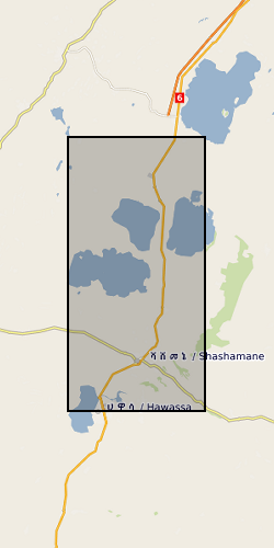
The RiftVolc GPS network was comprised of a total of 10 continuously recording stations deployed on Aluto and Corbetti Volcanoes between 2012 to present. At least 9 stations were recording data simultaneously except in 2012, 2016 and 2017 where 1, 8 and 5 stations were in operation respectively. Full details on station location and operation periods are provided in the attached README file.