 NERC Data Catalogue Service
Faults
Type of resources
Available actions
Topics
Keywords
Contact for the resource
Provided by
Years
Formats
Representation types
Update frequencies
Service types
Scale
-

Multiple calibrated laboratory images of experiments to determine leakage rates through faults and geological heterogeneities. Two sequences of images, and associated movie (avi file) depicting laboratory fault experiments as described in; Gilmore, K., Sahu, C., Benham, G., Neufeld, J., & Bickle, M. (2022). Leakage dynamics of fault zones: Experimental and analytical study with application to CO2 storage. Journal of Fluid Mechanics, 931, A31. doi:10.1017/jfm.2021.970
-

This vector dataset represents the vertical and non-vertical faults for the Fell Sandstone Formation (base Middle Border Group) in the Northumberland-Solway Basin (Carboniferous hot sedimentary aquifer resources).
-

This vector dataset compiles the vertical and non-vertical faults for the Permian hot sedimentary aquifers in the Cheshire (Collyhurst Sandstone Formation, CS) and the Worcester (Bridgnorth Sandstone Formation, BS) basins.
-
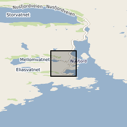
The database contains field measurements and field descriptions of pseudotachylytes and mylonites that formed at lower crustal conditions and that are now exposed on the Nusfjord ridge, Lofoten, northern Norway. The field measurements were used to derive earthquake source parameters associated with the generation of the Nusfjord pseudotachylytes.
-

This vector dataset compiles the vertical and non-vertical faults for the top and base of the Sherwood Sandstone Group in the Permo-Triassic Worcester, Wessex, East Yorkshire Lincolnshire and Cheshire basins.
-
Whole rock geochemical data from the Alpine Fault Zone. These data have been generated from systematic sampling through the Deep Fault Drilling Project - Phase 1 rock cores and from analyses of cuttings retrieved during the Deep Fault Drilling Project - Phase 2. Geochemical analyses on the fault rocks to understand the conditions at which they were deformed. The dataset is associated with the UK component of a major international campaign, the Deep Fault Drilling Project (DFDP). to drill a series of holes into the Alpine Fault, New Zealand. The overarching aim of the DFDP to understand better the processes that lead to major earthquakes by taking cores and observing a major continental fault during its build up to a large seismic event.
-

Structural geology data obtained by Land Survey staff during their mapping work. Originally designed for the Mid-Wales Mapping Programme but subsequently used by other teams. Holds details of planar structures, linear structures, folds, faults and veins.
-
The data comprises information on the subsurface structure of stratigraphic levels and units in the United Kingdom, detailing depth to and thickness of the units. These result from projects in different parts of the UK performed at different times. Common working scales are 1:50 000 and 1:250 000 with appropriate differences in detail. Much mapping results from interpretation of seismic data, and as a result many of the structural maps are in time rather than depth, although some have been depth converted.
-

This vector dataset represents the Variscan faults for the early Carboniferous limestone (ECL) in hot sedimentary aquifers in the UK, used by D J.R. Jones, T. Randles, T. Kearsey, T.C. Pharaoh, A. Newell (2023). https://doi.org/10.1016/j.geothermics.2023.102649.
-
Interpretations of fault positions, geometries and displacements, and seismic stratigraphic horizons. These are provided in the form of Seismic fault and horizon data as ‘Charisma fault sticks’ and ‘Charisma 2D interpretation lines’ ASCII files, respectively, exported from Petrel 2019. Additional CSV and XLSX files containing the compiled coordinate data are included. A readme file is also included explaining the contents of the different files and folders. Interpretations are from seismic profiles of the input oceanic plate section to the North Sumatra subduction zone. Results are published in: Stevens, D.E., McNeill, L.C., Henstock, T.J., Delescluse, M., Chamot-Rooke, N., Bull, J.M., 2020, Intraplate deformation offshore North Sumatra: New Insights from integration of IODP Expedition 362 results with seismic data. EPSL, 538, 116218.