 NERC Data Catalogue Service
Meteorological Data from BGS Virkisjökull-Falljökull Glacier Observatory, 2009-2020
Simple
- Date (Creation)
- 2020-08-24
0115 936 3276
0115 936 3276
0115 936 3276
0115 936 3276
0115 936 3276
- Maintenance and update frequency
- notPlanned Not planned
- GEMET - INSPIRE themes, version 1.0
- BGS Thesaurus of Geosciences
-
- Weather
- data.gov.uk (non-INSPIRE)
- Observatories
- Meteorological stations
- Meteorology
- dataCentre
- Keywords
-
- NERC_DDC
- Access constraints
- otherRestrictions Other restrictions
- Other constraints
- licenceOGL
- Use constraints
- otherRestrictions Other restrictions
- Other constraints
- The copyright of materials derived from the British Geological Survey's work is vested in the Natural Environment Research Council [NERC]. No part of this work may be reproduced or transmitted in any form or by any means, or stored in a retrieval system of any nature, without the prior permission of the copyright holder, via the BGS Intellectual Property Rights Manager. Use by customers of information provided by the BGS, is at the customer's own risk. In view of the disparate sources of information at BGS's disposal, including such material donated to BGS, that BGS accepts in good faith as being accurate, the Natural Environment Research Council (NERC) gives no warranty, expressed or implied, as to the quality or accuracy of the information supplied, or to the information's suitability for any use. NERC/BGS accepts no liability whatever in respect of loss, damage, injury or other occurence however caused.
- Other constraints
- Available under the Open Government Licence subject to the following acknowledgement accompanying the reproduced NERC materials "Contains NERC materials ©NERC [year]"
- Metadata language
- EnglishEnglish
- Topic category
-
- Geoscientific information
- Geographic identifier
-
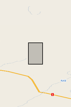
ICELAND [id=903000]
- Date (Creation)
- 1979
- Geographic identifier
-
IS
- Date (Revision)
- 2009
- Geographic identifier
-
ISL
- Date (Revision)
- 2009
))
- Begin date
- 2009-09-07
- End date
- 2020-05-18
Reference System Information
- Distribution format
-
-
TXT files
()
-
TXT files
()
0115 936 3276
0115 936 3276
- OnLine resource
-
Meteorological Data from BGS Virkisjökull-Falljökull Glacier Observatory, 2009-2020
(
WWW:LINK-1.0-http--related
)
Everest, J., Buxel, H., Bradwell, T., Shanahan, T., Mackay, J.D. (2020): Meteorological Data from BGS Virkisjökull-Falljökull Glacier Observatory, 2009-2020. British Geological Survey. (Dataset). https://doi.org/10.5285/72f0d514-365a-45c9-9d54-3cb0b9fc71fc
- OnLine resource
-
Meteorological Data from BGS Virkisjökull-Falljökull Glacier Observatory, 2009-2020
(
WWW:DOWNLOAD-1.0-http--download
)
This dataset presents meteorological records from 3 weather stations around a glacier in southeast Iceland from 2009-2020. The weather stations were installed as part of British Geological Survey’s Glacier Observatory project, and were positioned at different altitudes close to the ice to record glacier weather. The data is in text format, and records key meteorological parameters including temperature, relative humidity, atmospheric pressure, precipitation, wind speed and direction, and solar irradiance.
- Hierarchy level
- dataset Dataset
- Other
- dataset
Conformance result
- Date (Publication)
- 2011
- Explanation
- See the referenced specification
- Pass
- No
Conformance result
- Date (Publication)
- 2010-12-08
- Explanation
- See http://eur-lex.europa.eu/LexUriServ/LexUriServ.do?uri=OJ:L:2010:323:0011:0102:EN:PDF
- Pass
- No
- Statement
- The study operated three automated weather stations: AWS1 located 100m from the current glacier margin at 156m a.s.l. AWS3 50m from the icefall at 444m a.s.l. AWS4 situated on a clifftop overlooking the glacier at 858m a.s.l., close to the Equilibrium Line Altitude of the glacier.These were positioned at different altitudes to determine changes in weather parameters with height, thus producing eg, temperature or humidity gradients. All stations were wirelessly linked. On-site downloads were completed using Campbell Scientific LoggerNet 4.x series software. AWS1 maintained mobile phone telemetry enabling automatic remote downloads of data from all stations on a regular basis, and remote access for software updates and health checks. The stations were mounted on 1.5m Campbell Scientific tripods and used a Campbell Scientific CR800 datalogger. All AWS were solar powered.
- File identifier
- adb1eb5c-94b1-14a4-e054-002128a47908 XML
- Metadata language
- EnglishEnglish
- Hierarchy level
- dataset Dataset
- Date stamp
- 2025-11-13
- Metadata standard name
- UK GEMINI
- Metadata standard version
- 2.3
- Dataset URI
- http://data.bgs.ac.uk/id/dataHolding/13607659
Overviews
Spatial extent
Provided by
