 NERC Data Catalogue Service
GSNI 250K Bedrock
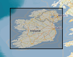
A 1:250,000 map showing the main geological bedrock divisions in Northern Ireland. The bedrock shown on GeoIndex map comprises the bedrock geology, which represents the outcrops (at surface) and subcrops (at near-surface, beneath superficial deposits) in Northern Ireland. For each rock unit there is a brief generalised description showing the major rock group, rock type and age under the following headings. LEX_D: The name of the selected area. This can be a group, formation or igneous intrusion e.g. dyke. LEX_RCS: Map code as it appears on the published 1:250,000 map. RCS_D: The name of the dominant types of rock (lithologies) in the different areas shown on the map e.g. granite. The names of the rock types given here are often generalisations, appropriate for the large areas of geological coverage at this scale. These areas may include a number of different geological formations whose distribution can only be portrayed on more detailed geological maps. RANK: Identifies formations and groups. Min_Time_D and Max_Tim_D: The age of the rock unit in terms of periods, relatively smaller units of geological time e.g. Carboniferous, Jurassic etc. Some of the map areas include rocks with a range of ages and these are shown as such e.g. Triassic to Cretaceous. The oldest metamorphic rocks are described as Moinian and Dalradian. The rocks range in age from those deposited relatively recently, some 2 million years ago, back to ancient and highly altered Precambrian rocks over 2500 million years old. In broad terms the youngest rocks are found in the south and east of the UK, the oldest in the north and west. VERSION: Version of the data. RELEASED: Date of release/update of the data. CAUTION Because of the generalisation and simplification used in the compilation of this map, it should not be used to determine the detailed geology of any specific sites. It is best used to provide a basic understanding of the geology of the country in general, and for showing the geology of large regions where broad trends are more important than specific details. Persons interested in the detailed geology of particular sites should consult the latest large-scale maps or the Geological Survey of Northern Ireland.
Simple
- Date (Creation)
- 2001
Distributor
British Geological Survey
-
Enquiries
028 9038 8461
Dundonald House, Upper Newtownards Road
,
BELFAST
,
BT4 3SB
,
United Kingdom
028 9038 8462
028 9038 8461
Point of contact
British Geological Survey
-
Enquiries
028 9038 8461
Dundonald House, Upper Newtownards Road
,
BELFAST
,
BT4 3SB
,
United Kingdom
028 9038 8462
028 9038 8461
User
British Geological Survey
-
Enquiries
028 9038 8461
Dundonald House, Upper Newtownards Road
,
BELFAST
,
BT4 3SB
,
United Kingdom
028 9038 8462
028 9038 8461
- Maintenance and update frequency
- continual Continual
- GEMET - INSPIRE themes, version 1.0
- BGS Thesaurus of Geosciences
-
- Geology
- Field geology
- General geology
- UK Location (INSPIRE)
- dataCentre
- Keywords
-
- NERC_DDC
- Access constraints
- otherRestrictions Other restrictions
- Other constraints
- licenceOGL
- Other constraints
- otherRestrictions
- Use constraints
- otherRestrictions Other restrictions
- Other constraints
- The copyright of materials derived from the British Geological Survey's work is vested in the Natural Environment Research Council [NERC]. No part of this work may be reproduced or transmitted in any form or by any means, or stored in a retrieval system of any nature, without the prior permission of the copyright holder, via the BGS Intellectual Property Rights Manager. Use by customers of information provided by the BGS, is at the customer's own risk. In view of the disparate sources of information at BGS's disposal, including such material donated to BGS, that BGS accepts in good faith as being accurate, the Natural Environment Research Council (NERC) gives no warranty, expressed or implied, as to the quality or accuracy of the information supplied, or to the information's suitability for any use. NERC/BGS accepts no liability whatever in respect of loss, damage, injury or other occurence however caused.
- Other constraints
- Conditions unknown
- Spatial representation type
- grid Grid
- Denominator
- 50000
- Metadata language
- EnglishEnglish
- Topic category
-
- Geoscientific information
- Geographic identifier
-
NIR
- Date (Revision)
- 2009
- Geographic identifier
-
NORTHERN IRELAND [id=181000]
- Date (Creation)
- 1979
N
S
E
W
))
- End date
- 2013 Before
- Unique resource identifier
- TM65 / Irish National Grid (EPSG::29900)
- Distribution format
-
Distributor
British Geological Survey
-
Enquiries
028 9038 8461
Dundonald House, Upper Newtownards Road
,
BELFAST
,
BT4 3SB
,
United Kingdom
028 9038 8462
028 9038 8461
- OnLine resource
- Open Data NI - 250k Geology homepage
- OnLine resource
- GSNI GeoIndex ( WWW:LINK-1.0-http--link )
- Hierarchy level
- dataset Dataset
- Other
- dataset
Conformance result
- Date (Publication)
- 2011
- Explanation
- See the referenced specification
- Pass
- No
Conformance result
- Date (Publication)
- 2010-12-08
- Explanation
- See http://eur-lex.europa.eu/LexUriServ/LexUriServ.do?uri=OJ:L:2010:323:0011:0102:EN:PDF
- Pass
- No
- Statement
- the bedrock geology represents the outcrops (at surface) and subcrops (at near-surface, beneath superficial deposits) in Northern Ireland.
- File identifier
- 9fc671d2-61ec-3b74-e044-0003ba9b0d98 XML
- Metadata language
- EnglishEnglish
- Hierarchy level
- dataset Dataset
- Date stamp
- 2025-11-13
- Metadata standard name
- UK GEMINI
- Metadata standard version
- 2.3
Point of contact
British Geological Survey
Dundonald House, Upper Newtownards Road
,
BELFAST
,
BT4 3SB
,
United Kingdom
+44 28 9038 8462
- Dataset URI
- http://data.bgs.ac.uk/id/dataHolding/13605553
Overviews
Spatial extent
N
S
E
W
Provided by

Associated resources
Not available