 NERC Data Catalogue Service
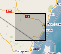
Weekly volume of water pumped for handpumps monitored with Smart Handpump technology, Kwale County, Kenya (NERC grants NE/L001950/1, NE/M008894/1)
This dataset contains a summary of the weekly volumetric output of pumps monitored using Smart Handpump sensors for 2014 and 2015. Grants that permitted the data collection include: Groundwater Risk Management for Growth and Development project (NE/M008894/1) funded by NERC/ESRC/DFID’s UPGro programme; New mobile citizens and waterpoint sustainability in rural Africa (ES/J018120/1) ESRC-DFID; Groundwater Risks and Institutional Responses for Poverty Reduction in Rural Africa (NE/L001950/1) funded by NERC/ESRC/DFID’s UPGro programme Notes: 1. The accuracy of these volume figures should be considered to be +/- 20%. 2. The dataset has gaps due to variable signal, and some attrition due to damage and vandalism. 3. Not all pumps in the study area were under monitoring. References: [1] P. Thomson, R. Hope, and T. Foster, “GSM-enabled remote monitoring of rural handpumps: a proof-of-concept study,” Journal of Hydroinformatics, vol. 14, no. 4, pp. 829–839, 05 2012. [Online]. Available:
https://doi.org/10.2166/hydro.2012.183
[2] Behar, J., Guazzi, A., Jorge, J., Laranjeira, S., Maraci, M.A., Papastylianou, T., Thomson, P., Clifford, G.D. and Hope, R.A., 2013. Software architecture to monitor handpump performance in rural Kenya. In Proceedings of the 12th International Conference on Social Implications of Computers in Developing Countries, Ochos Rios, Jamaica. pp. 978 (Vol. 991).
Simple
- Date (Creation)
- 2020-02-14
Principal investigator
University of Oxford
-
Dr R A Hope
(
School of Geography and the Environment
)
Oxford
,
OX1 3QY
,
Point of contact
University of Oxford
-
Nancy Gladstone
(
Smith School of Enterprise and the Environment
)
Oxford
,
OX1 3QY
,
- Maintenance and update frequency
- notApplicable notApplicable
- GEMET - INSPIRE themes, version 1.0
- BGS Thesaurus of Geosciences
-
- Accelerometers
- NGDC Deposited Data
- Groundwater
- dataCentre
- Keywords
-
- NERC_DDC
- Access constraints
- otherRestrictions Other restrictions
- Other constraints
- no limitations
- Other constraints
- The dataset is made freely available for access, e.g. via the Internet. Either no third party data / information is contained in the dataset or BGS has secured written permission from the owner(s) of any third party data / information contained in the dataset to make the dataset freely accessible.
- Use constraints
- otherRestrictions Other restrictions
- Other constraints
- The copyright of materials derived from the British Geological Survey's work is vested in the Natural Environment Research Council [NERC]. No part of this work may be reproduced or transmitted in any form or by any means, or stored in a retrieval system of any nature, without the prior permission of the copyright holder, via the BGS Intellectual Property Rights Manager. Use by customers of information provided by the BGS, is at the customer's own risk. In view of the disparate sources of information at BGS's disposal, including such material donated to BGS, that BGS accepts in good faith as being accurate, the Natural Environment Research Council (NERC) gives no warranty, expressed or implied, as to the quality or accuracy of the information supplied, or to the information's suitability for any use. NERC/BGS accepts no liability whatever in respect of loss, damage, injury or other occurence however caused.
- Other constraints
- Available under the Open Government Licence subject to the following acknowledgement accompanying the reproduced NERC materials "Contains NERC materials ©NERC [year]"
- Metadata language
- EnglishEnglish
- Topic category
-
- Geoscientific information
- Geographic identifier
-
KE
- Date (Revision)
- 2009
- Geographic identifier
-
KEN
- Date (Revision)
- 2009
- Geographic identifier
-
KENYA [id=687000]
- Date (Creation)
- 1979
N
S
E
W
))
- Begin date
- 2014-01-01
- End date
- 2015-12-15
- Unique resource identifier
- WGS 84 (EPSG::4326)
- Unique resource identifier
- Arc 1960 (deg) (EPSG::62106405)
- Distribution format
-
-
MS Excel
()
-
MS Excel
()
- OnLine resource
- https://doi.org/10.2166/hydro.2012.183
- OnLine resource
- https://www.bgs.ac.uk/services/ngdc/accessions/index.html#132765
- Hierarchy level
- dataset Dataset
- Other
- dataset
Conformance result
- Date (Publication)
- 2011
- Explanation
- See the referenced specification
- Pass
- No
Conformance result
- Date (Publication)
- 2010-12-08
- Explanation
- See http://eur-lex.europa.eu/LexUriServ/LexUriServ.do?uri=OJ:L:2010:323:0011:0102:EN:PDF
- Pass
- No
- Statement
- See: P. Thomson, R. Hope, and T. Foster, "GSM-enabled remote monitoring of rural handpumps: a proof-of-concept study," Journal of Hydroinformatics, vol. 14, no. 4, pp. 829-839, 05 2012. [Online]. Available: https://doi.org/10.2166/hydro.2012.183 Behar, J., Guazzi, A., Jorge, J., Laranjeira, S., Maraci, M.A., Papastylianou, T., Thomson, P., Clifford, G.D. and Hope, R.A., 2013. Software architecture to monitor handpump performance in rural Kenya. In Proceedings of the 12th International Conference on Social Implications of Computers in Developing Countries, Ochos Rios, Jamaica. pp. 978 (Vol. 991).
- File identifier
- 9ed6c5d2-124b-50ed-e054-002128a47908 XML
- Metadata language
- EnglishEnglish
- Hierarchy level
- dataset Dataset
- Date stamp
- 2025-11-13
- Metadata standard name
- UK GEMINI
- Metadata standard version
- 2.3
Point of contact
British Geological Survey
Environmental Science Centre,Keyworth
,
NOTTINGHAM
,
NOTTINGHAMSHIRE
,
NG12 5GG
,
United Kingdom
+44 115 936 3100
- Dataset URI
- http://data.bgs.ac.uk/id/dataHolding/13607584
Overviews
Spatial extent
N
S
E
W
Provided by

Associated resources
Not available