 NERC Data Catalogue Service
1:250K Geological Maps of Northern Ireland version 2
Simple
- Date (Publication)
- 1997
028 9038 8461
028 9038 8461
- Maintenance and update frequency
- asNeeded As needed
- GEMET - INSPIRE themes, version 1.0
- BGS Thesaurus of Geosciences
-
- Geology
- Maps
- UK Location (INSPIRE)
- dataCentre
- Keywords
-
- NERC_DDC
- Access constraints
- otherRestrictions Other restrictions
- Other constraints
- Crown Copyright – provided under the Open Government Licence V3.
- Use constraints
- otherRestrictions Other restrictions
- Other constraints
- The copyright of materials derived from the British Geological Survey's work is vested in the Natural Environment Research Council [NERC]. No part of this work may be reproduced or transmitted in any form or by any means, or stored in a retrieval system of any nature, without the prior permission of the copyright holder, via the BGS Intellectual Property Rights Manager. Use by customers of information provided by the BGS, is at the customer's own risk. In view of the disparate sources of information at BGS's disposal, including such material donated to BGS, that BGS accepts in good faith as being accurate, the Natural Environment Research Council (NERC) gives no warranty, expressed or implied, as to the quality or accuracy of the information supplied, or to the information's suitability for any use. NERC/BGS accepts no liability whatever in respect of loss, damage, injury or other occurence however caused.
- Other constraints
- Either: (i) the dataset is made freely available, e.g. via the Internet, for a restricted category of use (e.g. educational use only); or (ii) the dataset has not been formally approved by BGS for access and use by external clients under licence, but its use may be permitted under alternative formal arrangements; or (iii) the dataset contains 3rd party data or information obtained by BGS under terms and conditions that must be consulted in order to determine the permitted usage of the dataset. Refer to the BGS staff member responsible for the creation of the dataset if further advice is required. He / she should be familiar with the composition of the dataset, particularly with regard to 3rd party IPR contained in it, and any resultant use restrictions. This staff member should revert to the IPR Section (ipr@bgs.ac.uk ) for advice, should the position not be clear.
- Spatial representation type
- vector Vector
- Denominator
- 250000
- Metadata language
- EnglishEnglish
- Topic category
-
- Geoscientific information
- Geographic identifier
-
NIR
- Date (Revision)
- 2009
- Geographic identifier
-
NORTHERN IRELAND [id=181000]
- Date (Creation)
- 1979
))
- Begin date
- 1991
- End date
- 1997
- Unique resource identifier
- OSNI 1952 / Irish National Grid (EPSG::29901)
- Unique resource identifier
- TM65 / Irish Grid (EPSG::29902)
- Distribution format
-
-
VECTOR - SHP
()
-
TAB
()
-
Printed paper maps
()
-
GeoPackage
()
-
Raster: TIFF
()
-
VECTOR - SHP
()
028 9038 8461
- OnLine resource
-
OpenDataNI: GSNI 250K Geology
(
WWW:DOWNLOAD-1.0-http--download
)
A 1:250,000 map showing the main geological bedrock divisions in Northern Ireland. The data comprises the bedrock geology, which represents the outcrops (at surface) and subcrops (at near-surface, beneath superficial deposits) in Northern Ireland.
- OnLine resource
- GSNI GeoIndex ( WWW:LINK-1.0-http--link )
- Hierarchy level
- dataset Dataset
- Other
- dataset
Conformance result
- Date (Publication)
- 2011
- Explanation
- See the referenced specification
- Pass
- No
Conformance result
- Date (Publication)
- 2010-12-08
- Explanation
- See http://eur-lex.europa.eu/LexUriServ/LexUriServ.do?uri=OJ:L:2010:323:0011:0102:EN:PDF
- Pass
- No
- Statement
- The 1:250k Superficial Geological Map of Northern Ireland was compiled by the Geological Survey of Northern Ireland and published in 1991. The 1:250K Bedrock Geology map of Northern Ireland was compiled by the Geological Survey of Northern Ireland and published in 1997. The map was compiled from larger scale maps and may involve some generalization of the geology. It was in part derived from the 1:63 360 and 1:50 000 maps of the Geological Survey of Northern Ireland and the 1:100 000 maps of the Geological Survey of Ireland. Additional information was provided by University of St Andrews, University of Birmingham, The Queen’s University of Belfast and the University of Sheffield. Digital datasets were digitised from the published maps in December 2000. Revised for positional accuracy in September 2009.
- File identifier
- 9df8df52-d781-37a8-e044-0003ba9b0d98 XML
- Metadata language
- EnglishEnglish
- Hierarchy level
- dataset Dataset
- Date stamp
- 2025-11-13
- Metadata standard name
- UK GEMINI
- Metadata standard version
- 2.3
- Dataset URI
- http://data.bgs.ac.uk/id/dataHolding/13605376
Overviews
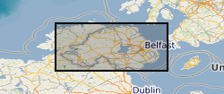
Spatial extent
Provided by
