 NERC Data Catalogue Service
Cardiff Urban Geo-Observatory, Groundwater Temperature Data 2014-2018
Simple
- Date (Creation)
- 2014
0115 936 3276
0115 936 3276
- Maintenance and update frequency
- asNeeded As needed
- GEMET - INSPIRE themes, version 1.0
- BGS Thesaurus of Geosciences
-
- UK Location (INSPIRE)
- Acid volcanic rocks
- Groundwater
- dataCentre
- Keywords
-
- NERC_DDC
- Access constraints
- otherRestrictions Other restrictions
- Other constraints
- licenceOGL
- Use constraints
- otherRestrictions Other restrictions
- Other constraints
- The copyright of materials derived from the British Geological Survey's work is vested in the Natural Environment Research Council [NERC]. No part of this work may be reproduced or transmitted in any form or by any means, or stored in a retrieval system of any nature, without the prior permission of the copyright holder, via the BGS Intellectual Property Rights Manager. Use by customers of information provided by the BGS, is at the customer's own risk. In view of the disparate sources of information at BGS's disposal, including such material donated to BGS, that BGS accepts in good faith as being accurate, the Natural Environment Research Council (NERC) gives no warranty, expressed or implied, as to the quality or accuracy of the information supplied, or to the information's suitability for any use. NERC/BGS accepts no liability whatever in respect of loss, damage, injury or other occurence however caused.
- Other constraints
- Available under the Open Government Licence subject to the following acknowledgement accompanying the reproduced NERC materials "Contains NERC materials ©NERC [year]"
- Spatial representation type
- grid Grid
- Metadata language
- EnglishEnglish
- Topic category
-
- Geoscientific information
- Geographic identifier
-
Cardiff [id=1248135]
- Date (Revision)
- 2002
))
- Begin date
- 2014
- End date
- 2018
- Unique resource identifier
- OSGB 1936 / British National Grid (EPSG::27700)
- Distribution format
-
-
.csv
()
-
.csv
()
0115 936 3276
- OnLine resource
-
Cardiff Urban Geo-Observatory : groundwater temperature data 2014-2018, metadata report
(
WWW:LINK-1.0-http--link
)
Farr, G.; Patton, A.M.; Boon, D.; James, D.; Coppell, L.; James, L.. 2019 Cardiff Urban Geo-Observatory : groundwater temperature data 2014-2018, metadata report. Cardiff, UK, British Geological Survey, 14pp. (OR/19/053)
- OnLine resource
-
Cardiff Urban Geo-Observatory, Groundwater Temperature Data 2014-2018
(
WWW:DOWNLOAD-1.0-http--download
)
Groundwater temperature data from a shallow urban aquifer in Cardiff, Wales, UK between 2014-2018. Monitoring was undertaken as part of the ‘Cardiff Urban Geo-Observatory’ project . Boreholes are located within the urban area of the City of Cardiff, Wales, UK. The majority of temperature sensors were installed within boreholes that monitor a shallow Quaternary aged sand and gravel aquifer, however the made ground and the Triassic Mercia Mudstone also represented. Temperature sensors installed in 53 boreholes, between depths of 1.5m and 12- m below ground, with measurements every 30 minutes. The dataset comprises of just over 3.5 million temperature measurements. Monitoring was undertaken by the British Geological Survey and was designed to address knowledge gaps of subsurface urban heat island and it use for heat recovery and storage.
- OnLine resource
-
Cardiff Urban Geo-Observatory, Groundwater Temperature Data 2014-2018
(
WWW:LINK-1.0-http--related
)
Farr, G., Patton, A.M., Boon, D., James, D., Coppell, L & James., L (2019): Cardiff Urban Geo-Observatory, Groundwater Temperature Data 2014-2018. British Geological Survey. (Dataset). https://dx.doi.org/10.5285/bf150dd6-7b28-49ca-b66f-8b543a33a5c0
- Hierarchy level
- dataset Dataset
- Other
- dataset
Conformance result
- Date (Publication)
- 2011
- Explanation
- See the referenced specification
- Pass
- No
Conformance result
- Date (Publication)
- 2010-12-08
- Explanation
- See http://eur-lex.europa.eu/LexUriServ/LexUriServ.do?uri=OJ:L:2010:323:0011:0102:EN:PDF
- Pass
- No
- Statement
- A mixture of temperature sensors were used in the monitoring period from 2014-2018. Sensors included; Hobo® ProV2 with a resolution of 0.02°C and an accuracy of ±0.21°C, Solinst Levellggers with a resolution of 0.003°C and an accuracy of ± 0.5°C and OTT sensors with a resolution of ± 0.1°C and an accuracy of ± 0.5°C. Since 2018 the network has been harmonised and the majority of boreholes are now instrumented with Solinst Levelloggers, that measure both water pressure and temperature. Groundwater temperatures were measured every 30 minutes between 2014 to 2018. Data from the instruments was collected manually every few months and was ingested into the BGS corporate database for sensor data before being extracted into the CSV format provided in this dataset.
- File identifier
- 9259a0ec-f4e7-04c3-e054-002128a47908 XML
- Metadata language
- EnglishEnglish
- Hierarchy level
- dataset Dataset
- Date stamp
- 2025-11-13
- Metadata standard name
- UK GEMINI
- Metadata standard version
- 2.3
- Dataset URI
- http://data.bgs.ac.uk/id/dataHolding/13607520
Overviews
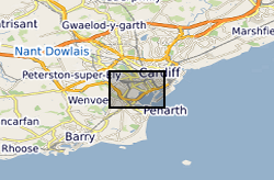
Spatial extent
Provided by
