
University of Leeds
Type of resources
Available actions
Topics
Keywords
Contact for the resource
Provided by
Years
Formats
Representation types
Update frequencies
status
Resolution
-
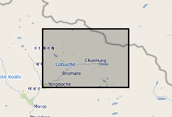
These data consist of a spreadsheet containing 557 ground control points (GCPs) collected in the Everest region of Nepal between October 2015 and October 2016. GCPs were collected using a Leica GS10 differential Global Positioning System (dGPS), post-processed against base station data at Syangboche. These final data have sub-centimetre accuracy (in x, y and z) in all cases. Point positions are heavily concentrated around meltwater ponds on the glacier surface, and prominent features around the glacier margin. These data will be used by PhD students and staff in the School of Geography, University of Leeds, to provide ground control for fine-resolution satellite imagery and Structure-from-Motion surveys to assess mass loss processes on Khumbu Glacier.
-
These data comprise input and output files from first principles molecular dynamics calculations on the soil mineral kaolinite, detailing its interactions with four different veterinary antibiotics, namely enrofloxacin, florfenicol, ciprofloxacin and florfenicol amine. The dataset includes the final, complete molecular dynamics trajectories of the sorption process of each antibiotic on the mineral surfaces (Al-terminated or Si-terminated). The data were collected as part of the NERC Exploring the Frontiers grant (Grant No. NE/X009572/1), ‘Antibiotic chemistry in agricultural soils: modelling mineral-antibiotic interactions from first principles’. The work fits within the broad field of ‘emerging contaminants’ in the environment, and understanding drivers of antimicrobial resistance (AMR). Full details about this nonGeographicDataset can be found at https://doi.org/10.5285/ce86e353-5068-48a6-99bc-4898201d6e6b
-
This data contains the results of student and professional perceptions surveys conducted in the UK before and after e-Learning training, as part of a project to determine the effectiveness of e-Learning as a training tool. The dataset include two surveys; before and after e-Learning training. Students and professionals were given two separate surveys which were combined to create one dataset. The surveys were collected between September 2015 and July 2018. The objective of the survey was to collect data on participants’ awareness, risk perceptions and self-reported behaviours on biosecurity for invasive species. The topics on both the before and after survey included age, role at institution, field of work/study, field activity environments, cleaning methods for equipment, outerwear/footwear and transport and awareness and perceptions of risk around invasive species and biosecurity campaigns. The data does not include the aggregated cleaning scores that were used for the analysis nor has it excluded any participants that were not used in the final data analysis. The dataset has been anonymised by removing names of respondents, email addresses, departments or organisations worked for or studied in, and text responses which could have made the participant identifiable. The research was funded by NERC project no NE/N008391/1. Full details about this nonGeographicDataset can be found at https://doi.org/10.5285/ac271791-b722-489c-9b68-b37316ec826c
-
The datasets contains species presence and background points, and their associated environmental data for non-native common wall lizard (Podarcis muralis). These data are included for local and national scale modelling of likelihood of species presence, as used in the modelling software MaxEnt. The .asc files included are the raw spatial data of parameters (i.e., distance to nearest road) used in modelling at various local regions, from which SWD 'samples with data' were extracted. Outputs from the local MaxEnt models produced the .txt files included. These serve as landscape layer inputs (habitat suitability and movement cost layers) for modelling population growth and spatial spread in the Individual based modelling platform, RangeShifter. Subsequent outputs of projected population growth (number of individuals per landscape cell) and x/y coordinates for each cell, are presented in files with the prefix Pop.csv and avg.csv (averaged data over 50 replicate runs). Full details about this dataset can be found at https://doi.org/10.5285/8ae3f9ef-9a75-4237-afbd-e01abe02e75b
-
The dataset provides transcripts from focus groups in Salima, Mangochi and Zomba (Malawi). The focus groups' discussions focused on important monthly agricultural activities in association with the climate services and extreme weather events. This outlined how climatic factors affected agricultural decision-making. The data were produced as part of NERC Program Science for Humanitarian Emergencies and Resilience (SHEAR). Grant reference - Improving Preparedness to Agro-Climatic Extremes in Malawi (IPACE-Malawi). Full details about this dataset can be found at https://doi.org/10.5285/199b0046-79a3-4e74-8152-17f10c376671
-
The dataset provides transcripts from focus groups in Salima, Mangochi and Zomba (Malawi). The focus groups' discussions concern the monthly agricultural activities in association with the climate services and extreme weather events. The data were produced as part of NERC Program Science for Humanitarian Emergencies and Resilience (SHEAR). Grant reference - Improving Preparedness to Agro-Climatic Extremes in Malawi (IPACE-Malawi). Full details about this dataset can be found at https://doi.org/10.5285/2b8cb09f-9348-4115-a90e-818eade599af
-

This dataset includes numerical simulation data of bottom heated convection in a rotating spherical shell. These numerical models are used to investigate the dynamics of convection in planetary cores. The simulations are performed over a range of thermal forcing and rotation rate [1-3] to study the various dynamical regimes of rotating convection. The dataset includes the simulation states to reproduce the simulations, time-series output of relevant variables from the simulations apart from post-processed diagnostic quantities. Due to large volume of the simulation state files only the initial, final and time averaged files are stored in the dataset in NETCDF format. The simulation diagnostics are provided in text, which includes time series, spatial and temporal averages of various diagnostic quantities (e.g. kinetic energy of convection) and forces to assess the underlying dynamics and heat transfer behaviour. The simulations have been performed using the Leeds Spherical Dynamo code [4], using ARC2, ARC3 and ARC4 HPC system in University of Leeds and the ARCHER and ARCHER2 HPC system. Refs: [1] https://doi.org/10.1017/jfm.2017.539 [2] https://doi.org/10.1017/jfm.2020.67 [3] https://doi.org/10.48550/arXiv.2410.03369 [4] https://github.com/Leeds-Spherical-Dynamo/leeds-spherical-dynamo
-

The world's population is predicted to grow from the current 7 billions to a plateau of approximately 9.2 billions to be reached within the next 60 years, representing roughly a 30 % increase in a not so distant future. The need for more energy efficient methods of producing synthetic fertilisers to meet the resulting increases in food demand and in crude (and bio) oils refining operations -on crudes of ever poorer quality- motivates the scientific community to reconsider the limitations of the mature technologies of synthetic fertilisers production and hydro-refining processes (HDS, HDN, HDM, HDO, hydrocracking) which both rely on the supply of hydrogen. Synthetic fertilisers necessitate hydrogen and nitrogen as feedstocks to make ammonia, which represents the building block for other fertilisers such as urea or ammonium nitrate. The current cheapest and most common means of producing hydrogen is natural gas steam reforming. With an abundance of natural gas reserves becoming exploitable worldwide in recent years via the hydraulic fracturing of shale gas, and given the ever more severe regulations on atmospheric pollution caused by flaring of associated gas from refineries and oil extraction operations, the production of hydrogen is very likely to remain dominated in the years to come by the process of steam reforming using natural gas as its feedstock (aka 'steam methane reforming' or 'SMR'). Conventional SMR technology usually features many unit operations (desulphurisation, pre-reforming, primary reforming, furnace, high and low temperature water gas shift (HT-WGS, LT-WGS), and final separation, with as many heat integration steps in between the units in order to reach an energy efficiency of roughly 80%. This efficiency is only attainable thanks to economies of scale, and SMR plants are consequently enormous. To avoid storage and transport costs of H2, the ammonia/ammonium nitrate/urea plants, or refinery operations are usually conducted near the site of SMR, therefore the production of the final products of fertilisers or clean fuels is very centralised, and thus vulnerable, as well as incurring large distribution costs. With sources of natural gas becoming more remote, widely distributed, shorter lived and quickly relocated, the process of converting natural gas to the final products fertiliser/clean fuel should become more mobile, down-scaleable, as fracking gas wells see their production decay with time and move to different sites. This proposal seeks to reduce significantly the energy and materials demand for the conversion of natural gas feedstocks into ready separated streams of the H2, N2 and CO2 products of steam reforming (the building blocks of urea production) by coupling the in-situ high temperature CO2 capture during the reforming reactions on a solid sorbent (a process called 'sorption enhancement') with the process of chemical looping steam reforming. A process is proposed with only two reactors, a reformer and a pressure/temperature swing separator, appropriate for the new, mobile, small scale industrial utilisation of natural gas, through realising the multiple synergies that are unique to the coupled process, and through the avoidance of expensive materials and awkward reformer geometries. Grant number: UKCCSRC-C2-181.
-

This poster on the UKCCSRC Call 2 project, Investigating the radiative heat flux in small and large scale oxy-coal furnaces for CFD model development and system scale up, was presented at the Cranfield Biannual, 21.04.15. Grant number: UKCCSRC-C2-193.
-
This poster on the UKCCSRC Call 2 project, Novel Materials and Reforming Processing Route for the Production of Ready-Separated CO2/N2/H2 from Natural Gas Feedstocks, was presented at the Cardiff Biannual, 10.09.14. Grant number: UKCCSRC-C2-181.