
University of Bergen
Type of resources
Available actions
Topics
Keywords
Contact for the resource
Provided by
Years
Formats
Representation types
Update frequencies
status
Resolution
-

This data was collected in order to investigate the level of evidence for: A) a relationship between the strength of the geodynamo and Earth surface UV-B irradiance; B) increased surface UV-B irradiance during the Laschamps Event (the last major geomagnetic excursion, ca. 41ka BP). The study considered subfossil Pinus Diploxylon (Pinus D.) pollen grains obtained from the annually laminated Japanese Lake Suigetsu sediment record (Bronk Ramsey et al., 2020; Nakagawa et al., 2003). The primary response variable is the abundance of para-coumaric acid (a UV-B absorbing compound) in the sporopollenin of the subfossil pollen grains. The secondary response variable is the probability of grain malformation. There are three key spreadsheets: 1) GCMS_pCA_day_dependent_calbration_simple.csv - estimated abundances of para-coumaric acid in the subfossil Pinus Diploxylon pollen at different depths/times of the Lake Suigetsu sediment core. 2) Suigetsu_malformations_simple.csv - malformations counts in the Lake Suigetsu subfossil Pinus Dipoxylon pollen 3) gc_cultivar_data_simple.csv - estimated abundance of para-coumaric acid in Pinus pollen in a controlled cultivar experiment (considering response to UV-B flux) Descriptor files (with corresponding names) are also provided. This dataset contains data generated by NERC Grant NE/Y002652/1:Reconstructing UV radiation over the Laschamps Geomagnetic Excursion.
-
This marine geophysical survey took place in August 2000 on board the RV Hakon Mosby on the AFEN slide, Shetlands margin area. This was a joint contribution of the University of Bergen and the British Geological Survey to the EU COSTA (Continental Slope Stability) project. The main objective of the COSTA project is the assessment of continental slope stability along the European Continental Margin with respect to natural processes and human activity. Subsurface seismic data was collected using BGS Deep-tow boomer and Halliburton sleeve gun system. Technical details of the survey are contained in University of Bergen report 100-02/00 (BGS2000/074).
-
This sampling and geophysical survey has been carried out by University of Bergen in collaboration with British Geological Survey (BGS), the survey took place in July 1996 on the North Sea Margin (North Sea Fan; Miller Slide and Faeroe-Shetland Channel) on board the RV Hakon Mosby. The purpose was to collect data as a contribution to the Europen Union’s project “European North Atlantic Margin (ENAM II): Quantification and modelling of large-scale sedimentary processes and fluxes” program. Sea floor data were collected using echo sounder. Sub-bottom profiling data were collected using airgun and deep tow boomer. Sample data were collected using gravity corer. These data are archived by University of Bergen, copy seismic records archived by BGS. Technical details of the survey are contained in University of Bergen ENAM II cruise report No. 2 (Non-BGS report reference 2006/9).
-
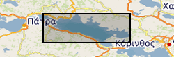
Fault and Horizon interpretations are provided for the Offshore Corinth Rift. The majority of the interpretations were based on 2D profiles from seismic reflection surveys collected by the R/V Maurice-Ewing in 2003, M.V. Vassilios in 1996 and 2003, and the R/V AEGEAO. Interpreted faults include major rift border faults as well as minor syn-rift faulting. Interpreted horizons include basement, a basin wide unconformity and five inferred transgressive surfaces based on variations in seismic character. Details of the fault and stratigraphic framework can be found in Nixon et al. (2016). Rapid spatiotemporal variations in rift structure during development of the Corinth Rift, central Greece. Tectonics, 35, 1225-1248.’ Published paper, Nixon, C. W., et al. (2016), Rapid spatiotemporal variations in rift structure during development of the Corinth Rift, central Greece, Tectonics, 35, 1225–1248, doi:10.1002/2015TC004026
-
The North Atlantic Norwegian Sea Exchange (NANSEN) data set comprises hydrographic profiles (temperature and salinity) and time series of current velocity, temperature and occasionally conductivity from the North Atlantic Ocean. The measurements were collected between 1986 and 1988 using conductivity-temperature-depth (CTD) profilers, moored current meters and thermistor chains. Data collection was undertaken by six laboratories in four countries (Faroes, Germany, Norway and the UK). The NANSEN project was conceived by the International Council for the Exploration of the Sea (ICES) Oceanic Hydrography Working Group. It aimed to study the hydrography and circulation of the Iceland Basin and the temporal and spatial variability of the inflows and outflows across the Greenland-Scotland Ridge. Current meter data from a number of laboratories involved in NANSEN and CTD data collected by UK participants are managed by the British Oceanographic Data Centre (BODC). A further 50 current meter series have been collected, but have not yet been acquired by BODC. The data will be subjected to the usual BODC quality control procedures for current meter series. The hydrographic data set collected during the NANSEN experiment has been compiled by the ICES Secretariat.
-
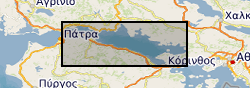
The data are derived from interpretation of seismic reflection profiles within the offshore Corinth Rift, Greece (the Gulf of Corinth) integrated with IODP scientific ocean drilling borehole data from IODP Expedition 381 (McNeill et al., 2019a, 2019b). The data include rift fault coordinate (location, geometry) information and slip rate and extension rate information for the major faults. Seismic reflection data were published in Taylor et al. (2011) and in Nixon et al. (2016). Preliminary fault interpretations and rate data, prior to IODP drilling, were published in Nixon et al. (2016). Details of datasets: The data can be viewed in GIS software (ArcGIS, QGIS) or the Excel and .dbf files can be used for viewing of rate data and import of fault coordinates into other software. The 4 folders are for different time periods with shape files for the N-Dipping and S-Dipping Faults in the offshore Corinth Rift and respective slip and extension (horizontal) rates. The shapefiles are digitised fault traces for the basement offsetting faults, picked from the Multichannel Seismic Data collected by the R/V Maurice Ewing. Fault traces are segmented and each segment has an average throw (vertical) rate (Tavg) in mm/yr. The rates for the segments are averages based on measurements at the ends of each segment. The major fault trace segments also have slip-rates (slip_rate) and extension-rates (ext_rate or extension_) in mm/yr. All rates as well as the names for major faults can be located in the attribute table of the shape files along with X- and Y-coordinates. The coordinate system is WGS84 UTM Zone 34N. The shape files can be loaded into a GIS (ArcGIS, QGIS etc.) allowing mapping and visualization of the fault traces and their activity rates. In addition, the attribute tables are .dbf files found within each folder. These have also been provided as .xlsx (Excel) files which include the fault coordinate information, and slip rates and extension rates along the major faults. References McNeill, L.C., Shillington, D.J., Carter, G.D.O., and the Expedition 381 Participants, 2019a. Corinth Active Rift Development. Proceedings of the International Ocean Discovery Program, 381: College Station, TX (International Ocean Discovery Program). McNeill, L.C., Shillington, D.J., et al., 2019b, High-resolution record reveals climate-driven environmental and sedimentary changes in an active rift, Scientific Reports, 9, 3116. Nixon, C.W., McNeill, L.C., Bull, J.M., Bell, R.E., Gawthorpe, R.L., Henstock, T.J., Christodoulou, D., Ford, M., Taylor, B., Sakellariou, S. et al., 2016. Rapid spatiotemporal variations in rift structure during development of the Corinth Rift, central Greece. Tectonics, 35, 1225–1248. Taylor, B., J. R. Weiss, A. M. Goodliffe, M. Sachpazi, M. Laigle, and A. Hirn (2011), The structures, stratigraphy and evolution of the Gulf of Corinth Rift, Greece, Geophys. J. Int., 185(3), 1189–1219.
-
The dataset comprises a diverse set of physical, chemical and biological data including: bacteria, carbon, chlorophyll, dissolved gases, light levels, nutrients, phytoplankton, productivity, respiration, salinity, temperature, trace elements and zooplankton. Measurements were gathered from the North Atlantic and Norwegian fjord waters between 1971 and 1998. The data arise from three sources: biological and hydrographic data collected between 1971 and 1975 at Ocean Weather Ship (OWS) India in the North Atlantic; conductivity-temperature-depth (CTD) casts, water samples, net samples and meteorological data from the four week Bergen Mesocosm experiment at Espegrend Marine Biological Field Station (Norway) in 1995; and the six week RRS Discovery cruise 221 to the North East Atlantic in 1996, where physical, chemical and biological data were collected. The data were collected using a variety of methods including: more than 500 CTD and SeaSoar profiles; nearly 1000 water bottle samples; over 600 net hauls; over 450 Secchi disk deployments; nearly 4000 multisizer samples; 23 production experiments; four drifting buoy tracks and 40 days of weather observations. The PRIME programme aimed to lay the basis for mathematical models to describe the role of plankton in biogeochemical fluxes within the oceans which have implications for climate regulation. The project was hosted by the School of Ocean Sciences, University of Wales, Bangor. Data management was undertaken by the British Oceanographic Data Centre and over 95% of the data collected are now assembled on a CD-ROM. The data are accompanied by an extensive users' guide (covering sampling protocol documentation), the structures used to store the data, and the data interrogation tools.
-
The World Climate Research Program (WCRP) Coupled Model Intercomparison Project, Phase 6 (CMIP6) data from the the EC-Earth-Consortium team EC-Earth3P model output for the "forced atmosphere experiment for 1950-2014" (highresSST-present) experiment. These are available at the following frequencies: Amon, LImon and Lmon. The runs included the ensemble member: r1i1p1f1. CMIP6 was a global climate model intercomparison project, coordinated by PCMDI (Program For Climate Model Diagnosis and Intercomparison) on behalf of the WCRP and provided input for the Intergovernmental Panel on Climate Change (IPCC) 6th Assessment Report (AR6). The the EC-Earth-Consortium team team consisted of the following agencies: La Agencia Estatal de Meteorología (AEMET), Barcelona Supercomputing Centre (BSC), Institute of Atmospheric Sciences and Climate (CNR-ISAC), Danish Meteorological Institute (DMI), Italian National Agency for New Technologies, Energy and Sustainable Economic Development (ENEA), Finnish Meteorological Institute (FMI), Helmholtz Centre for Ocean Research Kiel (Geomar), Irish Centre for High-End Computing (ICHEC), International Centre for Theoretical Physics (ICTP), Instituto Dom Luiz (IDL), Institute for Marine and Atmospheric research Utrecht (IMAU), Portuguese Institute for Sea and Atmosphere (IPMA), KIT Karlsruhe Institute of Technology, Royal Netherlands Meteorological Institute (KNMI), Lund University, Met Eireann, The Netherlands eScience Center (NLeSC), Norwegian University of Science and Technology (NTNU), University of Oxford, SURFsara, Swedish Meteorological and Hydrological Institute (SMHI), Stockholm University, Unite ASTR, University College Dublin, University of Bergen, University of Copenhagen, University of Helsinki, University of Santiago de Compostela, Uppsala University, University of Utrecht, Vrije Universiteit Amsterdam and Wageningen University. The official CMIP6 Citation, and its associated DOI, is provided as an online resource linked to this record.
-
The World Climate Research Program (WCRP) Coupled Model Intercomparison Project, Phase 6 (CMIP6) data from the the EC-Earth-Consortium team EC-Earth3P-HR model output for the "forced atmosphere experiment for 1950-2014" (highresSST-present) experiment. These are available at the following frequency: Amon. The runs included the ensemble member: r1i1p1f1. CMIP6 was a global climate model intercomparison project, coordinated by PCMDI (Program For Climate Model Diagnosis and Intercomparison) on behalf of the WCRP and provided input for the Intergovernmental Panel on Climate Change (IPCC) 6th Assessment Report (AR6). The the EC-Earth-Consortium team team consisted of the following agencies: La Agencia Estatal de Meteorología (AEMET), Barcelona Supercomputing Centre (BSC), Institute of Atmospheric Sciences and Climate (CNR-ISAC), Danish Meteorological Institute (DMI), Italian National Agency for New Technologies, Energy and Sustainable Economic Development (ENEA), Finnish Meteorological Institute (FMI), Helmholtz Centre for Ocean Research Kiel (Geomar), Irish Centre for High-End Computing (ICHEC), International Centre for Theoretical Physics (ICTP), Instituto Dom Luiz (IDL), Institute for Marine and Atmospheric research Utrecht (IMAU), Portuguese Institute for Sea and Atmosphere (IPMA), KIT Karlsruhe Institute of Technology, Royal Netherlands Meteorological Institute (KNMI), Lund University, Met Eireann, The Netherlands eScience Center (NLeSC), Norwegian University of Science and Technology (NTNU), University of Oxford, SURFsara, Swedish Meteorological and Hydrological Institute (SMHI), Stockholm University, Unite ASTR, University College Dublin, University of Bergen, University of Copenhagen, University of Helsinki, University of Santiago de Compostela, Uppsala University, University of Utrecht, Vrije Universiteit Amsterdam and Wageningen University. The official CMIP6 Citation, and its associated DOI, is provided as an online resource linked to this record.
-
WCRP CMIP6: the EC-Earth-Consortium team EC-Earth3-CC model output for the "abrupt-4xCO2" experiment
The World Climate Research Program (WCRP) Coupled Model Intercomparison Project, Phase 6 (CMIP6) data from the the EC-Earth-Consortium team EC-Earth3-CC model output for the "abrupt quadrupling of CO2" (abrupt-4xCO2) experiment. These are available at the following frequencies: Amon, Oday, Ofx, Omon and day. The runs included the ensemble member: r1i1p1f1. CMIP6 was a global climate model intercomparison project, coordinated by PCMDI (Program For Climate Model Diagnosis and Intercomparison) on behalf of the WCRP and provided input for the Intergovernmental Panel on Climate Change (IPCC) 6th Assessment Report (AR6). The the EC-Earth-Consortium team team consisted of the following agencies: La Agencia Estatal de Meteorología (AEMET), Barcelona Supercomputing Centre (BSC), Institute of Atmospheric Sciences and Climate (CNR-ISAC), Danish Meteorological Institute (DMI), Italian National Agency for New Technologies, Energy and Sustainable Economic Development (ENEA), Finnish Meteorological Institute (FMI), Helmholtz Centre for Ocean Research Kiel (Geomar), Irish Centre for High-End Computing (ICHEC), International Centre for Theoretical Physics (ICTP), Instituto Dom Luiz (IDL), Institute for Marine and Atmospheric research Utrecht (IMAU), Portuguese Institute for Sea and Atmosphere (IPMA), KIT Karlsruhe Institute of Technology, Royal Netherlands Meteorological Institute (KNMI), Lund University, Met Eireann, The Netherlands eScience Center (NLeSC), Norwegian University of Science and Technology (NTNU), University of Oxford, SURFsara, Swedish Meteorological and Hydrological Institute (SMHI), Stockholm University, Unite ASTR, University College Dublin, University of Bergen, University of Copenhagen, University of Helsinki, University of Santiago de Compostela, Uppsala University, University of Utrecht, Vrije Universiteit Amsterdam and Wageningen University. The official CMIP6 Citation, and its associated DOI, is provided as an online resource linked to this record.