 NERC Data Catalogue Service
Shale
Type of resources
Available actions
Topics
Keywords
Contact for the resource
Provided by
Years
Formats
Representation types
Update frequencies
Scale
-

The mechanical data (loads, displacements) recorded during double torsion experiments on samples of 6 shale materials and a sandstone. These experiments were conducted on the I12 beamline, Diamond Light Source, Harwell as part of beamtimes EE13824-1 and EE13824-2 between 26/02/17 and 03/03/17. The data were collected using the standard double-torsion technique, with a load cell behind the actuator recording applied force. The method and results are described in detail by Chandler et al, (2018,submitted) "Correlative optical and X-ray imaging of strain evolution during Double Torsion Fracture Toughness measurements in shale" The data was collected with the aim of correlating local deformation around a progressing fracture (through X-Ray and optical imaging) with recorded mechanical data from the loading system. The data was collected by M. Chandler, A-L Fauchille, J. Mecklenburgh, H. K. Kim and L. Ma, and was processed by M. Chandler and R. Rizzo. The complete dataset is present.
-
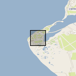
X-ray computed tomography (XCT) scans of four samples of consolidated shale from the Lower Jurassic (C.exaratum subzone) of the Cardigan Bay Basin (Wales, UK). The samples were taken from the Mochras Core, at depths of 789, 810, 812, and 818m (all samples within data measured in metres). Each sample is distinguished by its unique sample identification number (SSK). For each sample, there is a stack of XCT orthoslices (.tiff) files, and for SSK109633, an incomplete Avizo file. Mochras core location (aprox.) 52°48'39.74"N, 4° 8'48.09"W. Mochras Island, west of Llanbedr, Gwynedd, Wales, UK
-

Image data published in AGU paper "Estimation of Capillary Pressure in Unconventional Reservoirs Using Thermodynamic Analysis of Pore Images". The images of unconventional shale rock pores were captured using nano-CT and SEM imaging methods. Images are segmented into fluid (or pore) and rock phases and are stored in RGB format as JPG files. Images were used to produce the plots and data presented in the above referenced paper.
-

The mechanical data (confining and injection pressures) recorded during Vickers indentation experiments on samples of shale materials. These experiments were conducted on the I12 beamline, Diamond Light Source, Harwell as part of beamtime EE17606-1 between 31/01/18 and 05/02/18.
-

These data comprise geochemical results from upper Ediacaran organic-rich shales / mudstones from the Yangtze Craton (South China) from the Doushantuo Formation (member IV) and overlying lower Dengying Formation (= Miaohe Member). Ages range from about 570 to 550 Ma. The data consist of iron partitioning (Fe-speciation), phosphorus partitioning (P-speciation), bulk rock metal concentrations, total organic content and pyrite sulfur isotopes. Major and trace element concentrations of all samples were measured by inductively coupled plasma optical emission spectrometry and mass spectrometry, respectively, after quantitative HNO3-HFHClO4 digestion. Fe speciation was performed after the established methodology of Poulton and Canfield to extract operationally defined Fe phases, including Fe associated with carbonates (Fecarb), ferric oxides (Feox), magnetite (Femag), and pyrite (Fepy). The sum of these Fe pools constitutes the proportion of Fe that is considered highly reactive (FeHR) toward dissolved sulfide. Ratios of FeHR/FeT > 0.38 support FeHR enrichment and deposition under anoxic bottom water conditions, whereas values of <0.22 indicate deposition from oxic bottom waters. The intermediate range of 0.22 to 0.38 is regarded as equivocal because of the possibility for rapid sediment deposition or early diagenetic transformation of unsulfidized FeHR to poorly reactive sheet silicate minerals. For anoxic samples (FeHR/FeT > 0.38), the degree of sulfidation of the FeHR pool can be used to distinguish ferruginous (Fepy/FeHR <0.7) from euxinic (Fepy/FeHR > 0.8) conditions, with an intermediate zone ascribed to “possible euxinia”. Recent analyses of Holocene sapropels and the euxinic Lake Cadagno indicate that Fepy/FeHR > 0.6 may be a more suitable threshold for distinguishing ferruginous from possible euxinic conditions. Selected shale samples were analyzed for pyrite sulfur isotopes (δ34Spy), TOC, organic carbon isotopes (δ13Corg), and P phase associations. The P measurements use a sequential extraction method to distinguish the proportion of total P (PTot) associated with detrital apatite (Pdet) relative to potentially bioavailable and reactive (Preac) minerals, including Fe (oxyhydr)oxides (PFe),organic matter (Porg), and authigenic carbonate fluorapatite, biogenic apatite, and CaCO3-bound P (Pauth). For methods, see: S. W. Poulton, D. E. Canfield, Development of a sequential extraction procedure for iron: Implications for iron partitioning in continentally derived particulates. Chem. Geol. 214, 209–221 (2005). Fred T. Bowyer, Alexander J. Krause, Yafang Song, Kang-Jun Huang, Yong Fu, Bing Shen, Jin Li, Xiang-Kun Zhu, Michael A. Kipp, Lennart M. van Maldegem, Jochen J. Brocks, Graham A. Shields, Guillaume Le Hir, Benjamin J. W. Mills, and Simon W. Poulton Biological diversification linked to environmental stabilization following the Sturtian Snowball glaciation. Sci. Adv. 9 (34), eadf9999. DOI: 10.1126/sciadv.adf9999 (2023)
-

These data accompany a manuscript, titled: Stream and Slope Weathering Effects on Organic-rich Mudstone Geochemistry and Implications for Hydrocarbon Source Rock Assessment: A Bowland Shale Case Study All files with prefix 'Man_1' relate to this submission. The manuscript was submitted to the journal Chemical Geology in December 2016. Data include: 1) A range of photographs from the outcrop, drill cores, sub-samples, 'weathering grades' and thin section microphotographs from the Bowland Shale; 2) The results of mineralogical (whole rock powder x-ray diffraction; XRD) analyses for 18 subsamples; 3) The results of inorganic geochemical analyses (LECO elemental C and S, x-ray fluorescence major and trace elements) for 18 subsamples; 4) The results of organic geochemical analyses (Rock-Eval pyrolysis, d13Corg) for 20 subsamples; 5) RStudio scripts used to conduct statistical analyses (e.g., Principal Components Analysis) and generation of figures.
-
The data were produced by Joe Emmings, NERC-funded PhD student at the University of Leicester and British Geological Survey, between 2014 and 2017. Authors of these data: Joe Emmings a, b; Sarah Davies a; Christopher Vane b; Melanie Leng b, c; Vicky Moss-Hayes b; Michael Stephenson b a School of Geography, Geology and the Environment, University of Leicester, University Road, Leicester, LE1 7RH, UK. b British Geological Survey, Keyworth, Nottingham, NG12 5GG, UK. c School of Biosciences, Centre for Environmental Geochemistry, University of Nottingham, Sutton Bonington Campus, Leicestershire LE12 5RD, UK. Data include: 1) A range of photographs from the outcrop Hind Clough and boreholes MHD4 and Cominco S9, sample photographs, thin section scans, microphotographs (transmitted light and scanning electron microscopy) and hand specimen descriptions; 2) The results of 100 analyses from the outcrop Hind Clough and boreholes MHD4 and Cominco S9; x-ray fluorescence major and trace element concentrations, RockEval pyrolysis measurements, x-ray diffraction traces and LECO elemental C and S data. These data were interpreted together with 20 drill-core samples previously acquired from Hind Clough ('HC01' prefix). See http://dx.doi.org/10.5285/c39a32b2-1a30-4426-8389-2fae21ec60ad for further information regarding this drill-core dataset. Acknowledgements: This study was funded by NERC grant NE/L002493/1, a part of the Central England Training Alliance (CENTA). This study also received CASE funding from the BGS. Nick Riley (Carboniferous Ltd) is thanked for sharing his expertise, particularly regarding the field identification of marine faunas. Charlotte Watts is thanked for providing field assistance. Nick Marsh, Tom Knott and Cheryl Haidon are thanked for providing expertise and assistance during inorganic geochemical and mineralogical analyses.
-

Loan IDA number IDA271576. Microbial DNA concentrations from DNA extraction using Qiagen PowerSoil Pro DNA Extraction kit and subsequent PCR from shale and sandstone core samples collected and preserved for microbiology (shale SSK111456 and sandstone SSK111457) from UKGEOS Glasgow Observatory, borehole GGC01. DNA extractions and subsequent amplification using PCR indicate levels of microbial DNA below detection limits. Samples and data are derived from the UK Geoenergy Observatories Programme funded by the UKRI Natural Environment Research Council and delivered by the British Geological Survey.
-

Whole rock and sediment geochemical data covering a range of elements, where values are given in ppm (parts per million) or as a % (percentage). The data is ordered chronologically in an excel spreadsheet and each sample is given a ‘Sample ID’, ‘Lithology’, ‘Locality’, ‘Age’ and ‘Date analysed’, followed by whole rock and sediment values for the following elements; Ag, Al, As, Au, B, Ba, Be, Bi, Ca, Cd, Ce, Co, Cr, Cs, Cu, Fe, Ga, Ge, Hf, Hg, In, K, La, Li, Mg, Mn, Mo, Na, Nb, Ni, P, Pb, Pd, Pt, Rb, Re, S, Sb, Sc, Se, Sn, Sr, Ta, Te, Th, Ti, TI, U, V, W, Y, Zn, Zr. Cells which are highlighted orange signify that the value given was below the detection limit. The values in orange cells have been halved to maintain spreadsheet functionality (i.e. to remove ‘<’ symbols). Cells which have been highlighted blue signify that the value given was above the detection limit. ALS method:ME-MS41L (https://www.alsglobal.com/en/services-and-products/geochemistry/geochemistry-testing-and-analysis/whole-rock-analysis-and-lithogeochemistry) . The majority of the samples included in this data were collected in the UK, but, where appropriate, samples out with the UK were included. The majority of the data was collected from 2014 to 2019. Whole rock and sediment samples were analysed by solution ICP-MS. Samples of ~30 g were individually milled and homogenised, and 0.5 g were digested with aqua regia in a graphite heating block. The residue was diluted with deionised water (18 M¿ cm), mixed, and analysed using a Varian 725 instrument at ALS Minerals (Loughrea; method ID: ME-MS41L). This data was collected to better understand the low temperature cycling of Telurium (Te) and Sellenium (Se) in the geological environment. For example, a range of ochre samples were included in this database. Ochres are a modern precipitate commonly found in rivers and streams which flow through geographical areas with a history of mining resources which are rich in sulphides. Iron from the sulphides are leached out and deposited downstream, coating river and stream beds, giving a red, yellow or orange colouration. Ochres can be a sink for trace metals, so analysing the abundances of these can be informative from a resource perspective but also from an environmental hazard perspective. This would be useful for researchers who require reference data for whole rock and sediment data of a particular lithology or age. This data is was collected by, but not limited to the following individuals; John Parnell, Sam Spinks, Josef Armstrong, Liam A Bullock, Magali Perez, Xueying Wang & Connor Brolly.
-
The dataset describes the results of high pressure experimental measurements of three contrasting 'tight' rocks; a Bowland Shale, a Haynesville shale and Pennant sandstone. The results are tabulated as a csv file, listing experimental parameters, confining pressure, argon gas pore pressure and permeability. complementary measurements of key petrophysical data are provided - bulk modulus of compressibility, porosity TOC and density.