
Seismic surveys
Type of resources
Available actions
Topics
Keywords
Contact for the resource
Provided by
Years
Formats
Representation types
Update frequencies
Scale
-

There is a large deal of uncertainty as to the levels of stabilty of slope components of the European margin, other than localised detailed surveys completed using combination of sidescan sonar and swath bathymetry in recent years. Thesse surveys have revealed that the factors which control the locations of areas of potential slope failure are complex and manifold. Clearly slope gradients, sediment supply, physical oceanographic conditions and sediment type all have major roles to play, but their interaction is far from well understood. One of the problems to be addressed is the lack of a comprehenisve and focussed data synthesis with which to derive and test models of slope behaviour. A promising way in which this shortfall could be rectified would be to combine selected parts of the extensive survey database acquired by the telecommunications industry in it search for suitable pathways in which to lay earlier copper-core and now more recently, fibre-optic cable systems. These data would be interpreted in conjunction with a rigorous analysis of the industry's historical cable fault database which provides parameters of naturally occuring cable failures (through sediment failure, for example). Together these data will provide an understanidng of the geological characteristics of key parts of the European shelf, underpinned with the statistics of active slope processes over the most recent decades. The benefits of such a synthesis to both the telecommunications and hydrocarbon industries cannot be overstated.
-

1. Introduction 2. Geophysical database 3. Large-scale seismic interpretation 4. Large-scale glacial environment 5. 3D seismic investigations - Elephant Field 6. 3D seismic investigations - Repsol Block B 7. Discussion 8. Conclusions References
-
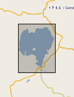
This is Seistec Boomer data acquired on Lake Tana. If not familiar with this variant of standard Boomer, it has a line-in-cone.
-

Marine geophysical survey of the NE BRazil and French Guiana continental margin onboard RRS Discovery (D275). The Amazon Cone is a deep-sea fan system that developed on a continental margin approximately 90-100 Myr following a rifting event. Gravity and flexure modelling suggest that the Cone sediments have loaded the margin almost to the limits of its strength. The investigators propose to carry out the first seismic refraction experiment to determine the structure of the crust and mantle that has been deformed by the Cone load. The experiment will provide new constraints on the structure, the nature of the ocean-continental boundary, the thermal and mechanical properties, and the resource potential of deep-water continental margins.
-

Mainly digital photos and Perl (pl) scripts provided as part of the P Bradbury studentship set of data.
-

A set of seismic track data and accompanying interpretations in XGEO proprietary format. All of the data are project based and are commercially obtained. The interpretations and track data are confidential to the customer. Track data is digitised from maps and charts and combined with digitised seismic profile data interpreted by the geologist. Data are held by project and by user id. All project based datasets are complete but these data are not available to users except where explicit permission has been sought from the data supplier. Seismic track data is usually sampled at every 10th shotpoint. This represents a sampling interval of 250m. The seismic sections will have limits in two way time up to 10 seconds. Data is presented to UKOOA and SEQ standards in terms of data formats. There is a low level of consistency in reflector nomenclature inter-project but totally consistent intra-project.
-
This document data set contains paper copies of many of the seismic reflection survey sections from the original seismic sections data set (ORIGSEISECS) . These have been made for interpretation. Most data are within the UK onshore area; although there are some UK near-shore and offshore (North Sea, Irish Sea) and foreign data. Most data were acquired for commercial hydrocarbon exploration and subsequently provided to BGS for use on specific projects. Some data were acquired by BGS and other public-sector bodies, e.g. BIRPS (British Institutes Reflection Profiling Syndicate ), for academic research. The documents are dyeline prints or plain-paper photocopies. They are stored folded in boxes, approx 40 sections per box, approx 530 boxes. There are a lot of duplicates, there being an interpreted and uninterpreted copy of many profiles. Mostly concentrated in areas prospective for coal, oil and gas.
-
This dataset contains the acquired distributed acoustic sensing (DAS) and hydrophone datasets from a project investigating the usage DAS at the UK Geoenergy Observatory (UKGEOS) research facility in Glasgow, funded by the UK Unconventional Hydrocarbons (UKUH) small project grant. The UKGEOS site in Glasgow has repurposed an abandoned coal mine to investigate its potential as a heat source and heat sink, and its borehole infrastructure includes pre-installed fibre-optic cables. DAS is a novel seismic monitoring technique that utilizes fibre-optic cables to measure small acoustic and seismic vibrations. Comparable to a very densely spaced hydrophone or geophone array, DAS provides unparalleled data resolution and insights into the subsurface. This dataset provides both active source and passive measurements of DAS at the UKGEOS Site 2 prior to the heat pump installation, providing geophysical baseline measurements of the mine. Alongside the acquired DAS data, data from a hydrophone array co-located to the fibre-optic cable was collected during the active source survey to provide a means of comparison to the DAS. NERC and ESRC jointly funded Unconventional Hydrocarbons in the UK Energy System Programme grant - Baseline seismic monitoring survey for UKGEOS Glasgow geothermal production using Distributed Acoustic Sensing (DAS)
-

This document data set contains original prints, on paper, sepia or film, of seismic reflection survey location (navigation) maps. These provide the location data for the seismic sections of the Original Seismic Sections (ORIGSEISECS) and Copy Seismic Sections (COPYSEISECS) datasets. Almost all data are within the UK onshore area; although there are some UK near-shore and offshore (North Sea, Irish Sea) and foreign data. Most data were acquired for commercial hydrocarbon exploration and subsequently provided to BGS for use on specific projects. Some data were acquired by BGS and other public-sector bodies, e.g. BIRPS, for academic research. All maps are digitised upon receipt (see LOCSEC database) and then archived in this data set. (Copies used to be used for interpretation purposes but this is no longer the case.) Documents stored rolled in tubes. Approx 800 maps.
-
The Seismic Locations and Sections database (LOCSEC) stores digitised seismic reflection survey location and line-interpretation data. Supplementary data stored includes map projection information and rock-unit seismic velocity data. The data are grouped by interpretation project area. Location data are input from digitised seismic shotpoint (SP) or common depth point (CDP) maps, or from direct input of digital navigation data. [See: Original Seismic Shotpoint Location Maps (ORIGSPMAPS) and Digital Seismic Shotpoint Location Maps (DIGSPMAPS) datasets]. Line-interpretation data are input from digitised pick-lines on manually interpreted printed seismic sections. [See: Copy Seismic Sections dataset (COPYSEISECS)]. In-house software is used for data management and display, to perform interpretation related tasks, e.g. depth-conversion, and to merge data into X, Y, Z form for input to 3D mapping and modelling packages such as EarthVision. Data in LOCSEC may also be related to the borehole interpretations held in the Stratigraphic Surfaces Database (SSD). Almost all data are within the UK Onshore area; although there are some UK near-shore and offshore (North Sea, Irish Sea) and foreign data. Most data were acquired for commercial hydrocarbon exploration and subsequently provided to BGS for use on specific projects. Some data were acquired by BGS and other public-sector bodies, e.g. BIRPS, for academic research.