 NERC Data Catalogue Service
Palaeoecology
Type of resources
Available actions
Topics
Keywords
Contact for the resource
Provided by
Years
Formats
Representation types
Update frequencies
-

These data were produced within the objectives of the NERC grant (alongside collaborator Gibbs at NOC, Southampton) and predominantly comprise biometric data collected under light microscope at x1500 magnification from the coccolithophore taxon Coccolithus pelagicus, a heavily calcified taxon with a long fossil record. The data was collected as part of a collaborative research effort bringing together the modern and fossil consortia within the UK Ocean Acidification research programme. The data are from batch culture experiments on both modern sub-species of C. pelagicus and provide cell size, coccosphere size, coccolith size and number of coccoliths per cell. The same parameters were measured from C. pelagicus from North Atlantic field and sediment trap samples from inside and outside bloom conditions. Again, the same parameters were also measured from C. pelagicus from exceptionally well-preserved fossil material from several shelf and off-shelf marine locations including New Jersey, Tanzania, California and the Bay of Biscay.
-
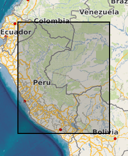
The dataset is the output of a NERC fellowship aimed to understand the long-term dynamics of tropical vegetation through palaeoecological analysis. For doing this, two sedimentary archives (Laguna Pindo and Laguna Baños) from Ecuador were radiocarbon dated and analysed for pollen, non-pollen palynomorphs, charcoal, chironomids, stable isotopes and XRF of tephra deposits. Each proxy was analysed at different resolution. Laguna Pindo is a mid-elevation lake (1250 m asl) that spans the last 50,000 years. Laguna Baños is an Andean lake located at 3800 m asl and contains sediments representative of the last 6500 years. Both water bodies are very shallow. The data is presented mainly in excel spreadsheets as raw data (except for radiocarbon dating data, which are the PDF files provided by NRCF), without any math treatment or conversion. Publication associated with NERC grant, Frazer Matthews-Bird, Stephen J. Brooks, Philip B. Holden, Encarni Montoya, and William D. Gosling (2016), Inferring late-Holocene climate in the Ecuadorian Andes using a chironomid-based temperature inference model. Clim. Past, 12, 1263-1280, 2016. doi:10.5194/cp-12-1263-2016
-
Results files from computer simulations of fluid flow for 3D models of Ediacaran organisms and communities, generated using computational fluid dynamics. Simulations performed using the simulation software package COMSOL Multiphysics. Root folder names refer to initial trials ‘Cylinder Tests’), modern organisms (‘Chondrocladia lyra’), Ediacaran organisms (‘Pectinifrons’ and ‘Pterdinium’), and Ediacaran surfaces (‘Avalon’ and ‘White Sea’ surfaces). Sub-folder and file names refer to simulations performed with different models (e.g., ‘Base’, ‘Filled’ and ‘Flush’ Petridinium models), model orientations (e.g., 0°, 90°, and 180° to the inlet), current velocities (e.g., 0.15, 0.5 and 0.85 m/s), and turbulence models (e.g., Spalart Allmaras, shear stress transport, and large eddy simulation). Further details for Pectinifrons and Pteridinium available in Darroch et al. 2022 (https://doi.org/10.1017/pab.2022.2) and Darroch et al. 2023 (https://doi.org/10.1016/j.isci.2023.105989), respectively. Files can be opened with COMSOL Multiphysics (www.comsol.com) versions 5.6 or 6.0 and above.
-

This data was collected in order to investigate the level of evidence for: A) a relationship between the strength of the geodynamo and Earth surface UV-B irradiance; B) increased surface UV-B irradiance during the Laschamps Event (the last major geomagnetic excursion, ca. 41ka BP). The study considered subfossil Pinus Diploxylon (Pinus D.) pollen grains obtained from the annually laminated Japanese Lake Suigetsu sediment record (Bronk Ramsey et al., 2020; Nakagawa et al., 2003). The primary response variable is the abundance of para-coumaric acid (a UV-B absorbing compound) in the sporopollenin of the subfossil pollen grains. The secondary response variable is the probability of grain malformation. There are three key spreadsheets: 1) GCMS_pCA_day_dependent_calbration_simple.csv - estimated abundances of para-coumaric acid in the subfossil Pinus Diploxylon pollen at different depths/times of the Lake Suigetsu sediment core. 2) Suigetsu_malformations_simple.csv - malformations counts in the Lake Suigetsu subfossil Pinus Dipoxylon pollen 3) gc_cultivar_data_simple.csv - estimated abundance of para-coumaric acid in Pinus pollen in a controlled cultivar experiment (considering response to UV-B flux) Descriptor files (with corresponding names) are also provided. This dataset contains data generated by NERC Grant NE/Y002652/1:Reconstructing UV radiation over the Laschamps Geomagnetic Excursion.
-

This dataset is the output of a NERC fellowship aimed to understand the long-term dynamics of tropical vegetation through palaeoecological analysis. For doing this, two sedimentary archives (Laguna Pindo and Laguna Baños) from Ecuador were radiocarbon dated and analysed for pollen, non-pollen palynomorphs, charcoal, chironomids, stable isotopes and XRF of tephra deposits. Each proxy was analysed at different resolution. Laguna Pindo is a mid-elevation lake (1250 m asl) that spans the last 50,000 years. Laguna Baños is an Andean lake located at 3800 m asl and contains sediments representative of the last 6500 years. Both water bodies are very shallow. The data is presented mainly in excel spreadsheets as raw data (except for radiocarbon dating data, which are the PDF files provided by NRCF and are available in the NGDC), without any math treatment or conversion (unless specified). NERC fellowship is NE/J 018562/1.
-
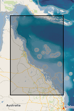
Four datasets for NERC grant NE/J023329/1, Paluma Shoals reef complex, Halifax Bay, central Great Barrier Reef, Australia. DATASET 1: Single Beam acoustic survey data. This dataset comprises the single beam acoustic data that was collected from transects across the Paluma Shoals reef complex, Halifax Bay, central Great Barrier Reef, Australia. The dataset comprises of depth measurements (m) and the latitudinal and longitudinal coordinates of 58,255 point samples across the study area. The dataset was used to construct Figure 1C in Morgan, K. M., Perry, C. T., Smithers, S. G., Johnson, J. A., & Daniell, J. J. (2016). Evidence of extensive reef development and high coral cover in nearshore environments: implications for understanding coral adaptation in turbid settings. Scientific Reports, 6. DATASET 2: Paluma Shoals core data (sedimentology and palaeoecology This dataset includes all collected sedimentary and coral palaeoecological data collected from cores from across the Paluma Shoals Reef Complex, Halifax Bay, central Great Barrier Reef, Australia. This includes 1) a list of the cores recovered, their geographic location and their depths; 2) data on the mud and carbonate content of the sediment matrix from each core; 3) grainsize data from each core; 4) data from thin section analysis from each delineated facies in cores; and 5) downcore data on coral constituent abundance. DATASET 3: Core radiocarbon dates This dataset comprises the radiocarbon dates obtained from coral samples from cores collected across the Paluma Shoals Reef Complex, Halifax Bay, central Great Barrier Reef, Australia. Dates are from the NERC Radiocarbon dating lab (SUERC) in East Kilbride. DATASET 4: Benthic video imagery This dataset comprises screen grab images collected along towed transects across the Paluma Shoals reef complex, Halifax Bay, central Great Barrier Reef, Australia. Each image has the relevant lat, long coordinates printed on the top right hand corner. The sites names (folders) relate to the sites described in the following paper: Morgan KM, Perry CT, Smithers SG, Daniell JJ and Johnson JA (2016) Extensive reef development within the “mesophotic” nearshore Great Barrier Reef: Evidence for intra-regional variations in coral resilience. Scientific Reports 6:29616. DOI: 10.1038/srep29616