 NERC Data Catalogue Service
Oxygen isotopes
Type of resources
Topics
Keywords
Contact for the resource
Provided by
Years
Formats
Representation types
Update frequencies
-

Photographs, 18O/16O isotopic ratios, XRF-derived elemental and N, C concentration data are provided for sediment cores from Deep Sea Drilling Project Site 225, central Red Sea. This site was originally drilled in April 1972 by rotatary drilling to recover cores through parts of the Plio-Pleistocene sediments for studies of past Red Sea water properties and regional climate. The rotary drilling disturbed the sediments by varied amounts, though left some 1.5-m sections of core almost intact. The X-ray fluorescence (XRF) data comprise elemental proportions for the core archive sections selected where they showed the least drilling disturbance. These and the core photographs were obtained at Kochi University, Japan, using an ITRAX core scanner during 2023 and 2024. Given the age of the cores, the archive sections are not perfectly flat, hence the ITRAX-derived elemental data may be distorted by varied distance between the sensor and the core, as well as by cracks within the core. The user needs to judge these data against the core photographs. As the lighter 16O isotope is evaporated preferentially over 18O and tends to get locked up in ice sheets during glacial periods, measurements of the ratio 18O/16O in carbonate sediments are often useful for recording evidence of global climatic cycles. In the Red Sea, the ratio is further affected by local evaporation, as the basin has been variably isolated from the Indian Ocean, partly as a result of sea-level variations affecting the exchange of water between the basins. Samples of ~20 cm3 were selected with two sets of intervals. Coarse-interval sampling was chosen spanning the Plio-Pleistocene for reconnaissance, while denser sampling was carried out across particular intervals of scientific interest. Within these intervals, the shells of foraminifera were separated into different species. Shells of Cibicidoides mundulus were primarily selected for measurements of 18O/16O. Analyses were carried out in 2024 at the University of Southampton (UK) using a Kiel carbonate device coupled to a Mat253 IRMS. XRF core scanning and sampling were carried out by technical staff of the Marine Core Research Institute, Kochi University under supervision of the IODP Core Curator Yusuke Kubo. Diederik Liebrand disaggregated the samples, separated the foraminifera shells and carried out the oxygen isotopic measurements. Selected samples were also analysed for nitrogen and carbon contents (weight percent of bulk sample in columns B and C) at the University of Liverpool by Steve Crowley.
-

Monthly sampling of cave drip and lake water from St Michaels Cave and Ragged Staff Cave, Gibraltar.
-

Data collected from IODP Expedition 353, Site U1446. Data represent ISM derived rainfall and runoff proxies across Termination II. Mid-depth on CCSFA scale. Two age columns derived from age models based on LR04 benthic oxygen isotope record and AICC2012 chronology. Sheet 2 include Globigerinoides ruber sensu-stricto oxygen isotope data, Mg/Ca, Mn/Ca, U/Ca and Nd/Ca Sheet 3 include discrete portable X-Ray Fluorescence data for Ti, Al, K and Rb.
-

Provided here are in-situ Si and O isotope compositions of Detrital Jack Hills and Lachlan Fold Belt zircons. These data formed the basis of the research published as: Origin and significance of Si and O isotope heterogeneities in Phanerozoic, Archean, and Hadean zircon, Trail et al., (2018), PNAS 115 (41), 10287-10292 The data are provided in a single Excel spreadsheet, with multiple tabs, which are as follows: 1. Sample description and analytical method summaries 2. Solution and laser-fluorination data for characterisation of the standards used in the Ion Probe measurement sessions 3. Ion Probe (In-situ) Si and O isotope data for the Lachlan Fold Belt and Duluth Gabbro zircons 4. Ion Probe (In-situ) Si and O isotope data for the detrital Jack Hills zircons, as well as 207Pb/206Pb age estimates 5. Raw Ion Probe Si and O isotope data for LFB samples 6. Raw Ion Probe Si and O isotope data for Jack Hills samples 7. Ion Probe (In-situ) Si isotope data for the Lachlan Fold Belt zircons (utilising O- hyperion source)
-

This dataset includes the (stable) oxygen and carbon isotopic composition of benthic foraminifer tests (n= 686) and the (radiogenic) isotopic composition of the terrigenous fraction of marine sediments (n= 75), all sampled from Eocene to Oligocene-aged sediments recovered at Ocean Drilling Program (ODP) Site 689 and 690 (Maud Rise, Southern Ocean)
-
Isotope analysis data. Project details: The continental crust is our only archive of Earth history; not just of the crust itself but of the hydrosphere, atmosphere and biosphere, and of the deep Earth through its interactions with the crust. This archive, like the rock record itself, is incomplete and much effort is focused on interrogating the crust to gain a clearer and more complete picture of Earth history. The continental rock record is episodic with, for example, ages of igneous crystallization, metamorphism, continental margins, and seawater and atmospheric proxies distributed about a series of peaks and troughs that in part correspond with the cycle of supercontinent assembly and dispersal. At the core of the debate is what these well-established peaks of ages in the geological record represent and how they develop. The peaks of ages correspond with periods of global assembly of continents to form supercontinents. The project will address whether the peaks of ages are primary features associated with supercontinent assembly or break up, or they are they secondary features representing greater preservation potential at the times of supercontinent assembly. Our work will focus on the Rodinian supercontinent cycle, which extends from initiation of convergent plate interaction around 1.7 Ga, to continental collision at 1.1-1.0 Ga during the Grenville orogeny, to final breakup of the supercontinent by 0.54 Ga. Detrital zircons from sedimentary units throughout the supercontinent cycle provide a record of the magmatic activity for which the igneous rocks are often no longer preserved. We will determine (i) the ages ranges of magmatic activity preserved in the sedimentary rocks in the 600 Ma pre-collision phase, and (ii) how and when the distinctive Grenville peak of ages developed by comparing the zircon record from samples pre-, syn- and post- Rodinian supercontinent assembly with estimated volumes of magma and numbers of zircons produced during the same interval. This will differentiate primary generation processes from secondary processes, constraining when the dominant age peak developed, the tectonic processes that operated, and hence the method by which it developed. The wider implications of when the continental crust formed are considerable. Studies of continental growth continue to uncritically assume that the geological and isotopic record provide insight into processes of crust formation. Until it can be established whether the record is the outcome of generational or preservational processes, or a combination of both, then drawing conclusions on this fundamental question in the Earth Sciences are premature. If the record is a preservational record then this impacts on understanding continental growth through time and on secondary questions of how the crustal record is used to unravel the temporal evolution of the hydrosphere and biosphere, and the distribution of mineral deposits.
-

This spreadsheet contains 21 oxygen isotope measurements for hematite and mixed hematite/goethite samples from the supergene profiles of the Spence and Cerro Colorado porphyry copper deposits in the Central Andes. Columns are also included which contain calculated isotopic values for weathering fluids which were present at the time of iron oxide formation. These data are presented and discussed in the G-cubed paper 'A rusty record of weathering and groundwater movement in the hyperarid Central Andes' (Shaw et al., 2021). Weathering fluid isotopic values are calculated using the published fractionation factors of Clayton & Epstein (1961), Yapp (1990) and Bao & Koch (1999). The authors have the most confidence in the fluid values obtained using the fractionation factor of Yapp (1990), for reasons outlined in the publication.
-
Stable Isotope and trace element analyses (Ca, Sr, Mg, Fe and Mn concentrations) derived from Cretaceous Belemnites including Duvalia tornajoensis, D. cf. lata constricta, D. binervia, D. cf. emericii, Hibolithes, H. cf. jaculoides, Berriasibelus, Castellanibelus and Pseudobelus.
-

Dual stable isotope analysis comprising nitrogen-15 and oxygen-18 ratios for groundwater samples collected every 2-3 months over one hydrogeological year from the East Riding of Yorkshire. Isotopic ratios for nitrogen-15, oxygen-18 are both presented as raw and processed to NAIR and VSMOW, respectively. The data are in the form of a Microsoft Excel workbook containing Isotope Ratio Mass Spectrometer runs. The data were collected to understand key sources of nitrate contamination in Chalk groundwater and the dominant processes they undergo, and the extent of any attenuation. The Chalk catchments and the River Terrace Gravel catchment were compared, allowing conclusions to be drawn on the role of nitrate transformation, and the dominant location of transformations, to increase understanding of nitrate dynamics in agricultural systems. Groundwater samples were collected by the University of Leeds, the Environment Agency, Yorkshire Water and South East Water. Nitrate isolation and data interpretation carried out by Josephine McSherry, supervised by L. Jared West and Simon Bottrell. Mass spectrometry was carried out by Rob Newton and Bob Jamieson at the University of Leeds. No isotopic data are absent from the dataset, however oxygen contamination (resulting from the isolation method and since resolved) severely affected run O34b-O. Hydrochemical data relevant to the groundwater samples are not included as they are the property of the Environment Agency, Yorkshire Water or South East Water.
-
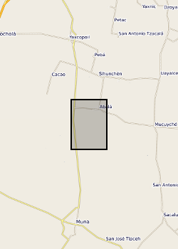
Surface waters and shallow groundwater samples were collected by completely filling 30 mL polyethylene bottles, which were then sealed with electrical tape to minimise the risk of evaporative loss. Rainwater samples were integrated samples of total monthly rainfall collected in a specially-adapted rainfall collector following IAEA protocols (IAEA http://www-naweb.iaea.org/napc/ih/documents/userupdate/sampling.pdf [accessed 22 June 2012). Mexico, State of Yucatan. Yaal Chac (lake) (lake centre is Lat: 20.595274 degrees; Long: -89.711301 degrees), Abala Well (Lat: 20.649044 degrees; Long: -89.679814 degrees) and Xanil ha Cave (Lat: 20.650809 degrees; Long: -89.697426 degrees) Rainwater sampler was located adjacent to the lake. Refer to accompanying map for the precise location of the sampling sites.