 NERC Data Catalogue Service
Multibeam
Type of resources
Available actions
Topics
Keywords
Contact for the resource
Provided by
Years
Formats
Representation types
Update frequencies
status
-
Multibeam bathymetric Echosounder (MBES) and Sparker seismic acquired August 2019. NSFGEO-NERC Grant: Tsunamis from large volume eruptions
-
The Mariana Trench was surveyed with a Kongsberg EM 124 gondola-mounted to the hull of the 225-foot DSSV Pressure Drop. The survey was conducted over the course of two weeks – April 19th – May 6th, 2019. The data meet the requirements for IHO Special Order standards.
-

The Molloy Hole was surveyed with a Kongsberg EM 124 gondola-mounted to the hull of the 225-foot DSSV Pressure Drop. The survey was conducted over the course of three days – August 24-26, 2019. The data meet the requirements for IHO Order 1 standards.
-
The Brownson Deep area of the Puerto Rico Trench was surveyed with a Kongsberg EM 124 gondola-mounted to the hull of the 225-foot DSSV Pressure Drop. The survey was conducted over the course of two days – December 18-19, 2018. The data meet the requirements for IHO Special Order standards.
-
The South Sandwich Trench was surveyed with a Kongsberg EM 124 gondola-mounted to the hull of the 225-foot DSSV Pressure Drop. The survey was conducted over the course of seven days – February 2-9, 2019. The data meet the requirements for IHO Special Order standards.
-

The Java Trench was surveyed with a Kongsberg EM 124 gondola-mounted to the hull of the 225-foot DSSV Pressure Drop. The survey was conducted over the course of two weeks – March 26th – April 9th, 2019. The data meet the requirements for IHO Special Order standards.
-
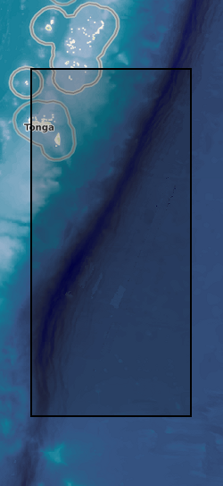
The Tonga Trench was surveyed with a Kongsberg EM 124 gondola-mounted to the hull of the 225-foot DSSV Pressure Drop. The survey was conducted over the course of two weeks – May 29 – June 6, 2019. The data meet the requirements for IHO Special Order standards.
-
The NERC-funded QICS controlled CO2 release experiment (located offshore Oban, Scotland) mimics the formation of a new CO2 seep in the marine environment. At the site, CO2 is injected at an onshore well head, and a stainless steel pipe transports the CO2 under the seabed. Approximately 350 m offshore, the CO2 is released through a perforated screen into the 12 metres of overlying marine sediment, which is at approximately 10 metres water depth. During spring/summer 2012, 4.2 tonnes of CO2 was released at the QICS experimental site. CO2 bubbles emerged from the seafloor ~30m to the west of the site and individual plumes covered a total area of ~ 350m2. Bubble stream location was recording using audio (acoustic) and visual techniques (photography, video). Both techniques are useful for recording the general location of plumes. However their 2D nature made it hard to characterise individual plumes and their exact locations. The QICS1 experiment included 200 deployments/recoveries of instruments, collection of 1,300 samples, and installation of 1600 m of cable and placement of 24 cages of indicator species on the seabed. In order to aid planning and operation during potential further experiments at the site it would be beneficial to utilise a robust and accurate method of recording the locations of equipment, samples and CO2 bubble streams. In this review, the four main types of submarine geolocation technologies are detailed and compared, and best available models (as of June 2013) are detailed. Grant number: UKCCSRC-C1-31.
-
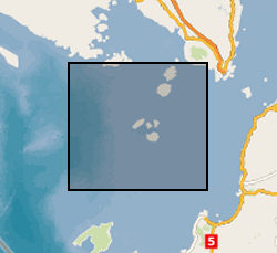
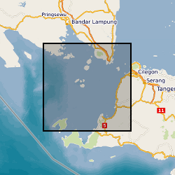
The data set comprises single channel seismic from the Sunda Strait, Indonesia. The data were acquired in 2019 to research the 1883, Krakatau volcanic eruption.
-
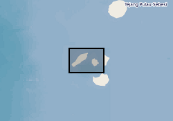
Single Channel seismic data, Sound source - 8kJ Sparker; Recorder - EG&G 8 element marine hydrophone (streamer), stored in jpeg and SEGY files. Multibeam bathymetric data recorded by Teledyne Reson T20-P Multibeam echosounder (MBES) 200 - 400kHz. Positioning system using Differential Global Positioning System (DGPS) Trimble SPS 461 with OmniSTAR signal correction and computer-based navigation/data acquisition system with Qinsy Acquisition software. Hunt, J.E., Tappin, D.R., Watt, S.F.L., Susilohadi, S., Novellino, A., Ebmeier, S.K., Cassidy, M., Engwell, S.L., Grilli, S.T., Hanif, M., Priyanto, W.S., Clare, M.A., Abdurrachman, M., Udrekh, U., 2021. Submarine landslide megablocks show half of Anak Krakatau island failed on December 22nd, 2018. Nature Communications 12, 2827.