
Mine waters
Type of resources
Available actions
Topics
Keywords
Contact for the resource
Provided by
Years
Formats
Representation types
Update frequencies
Scale
-
The data release includes initial interpretation from test pumping of boreholes at the UK Geoenergy Observatories (UKGEOS) Glasgow facility. This release from the British Geological Survey (BGS) covers a programme of test pumping carried out in ten boreholes in January and February 2020. It contains contractors reports and data sheets, BGS data sheets of data logger and manual dip data in the pumped borehole and in the observation boreholes. Step tests and five hour constant rate tests were performed in nine of the boreholes and a slug (falling/rising/head) test was performed in one borehole. Further details can be found in the accompanying report http://nora.nerc.ac.uk/id/eprint/530507
-

Reports detailing investigations into mine water discharges and potential effects on aquifers in the East Midlands Coalfield and in the Lake District.
-

The data release includes groundwater chemistry data from 15 samples collected during the borehole test pumping phase at the UK Geoenergy Observatories (UKGEOS) Glasgow facility. This release from the British Geological Survey (BGS) covers groundwater samples collected between 14 January 2020 and 21 February 2020 and then analysed for the concentrations of selected parameters at BGS and other laboratories. It contains a report and 2 data sheets. Further details can be found in the accompanying report http://nora.nerc.ac.uk/id/eprint/531098/.
-

The data release includes groundwater chemistry data from 8 samples and 2 tap water samples collected during the borehole construction phase at the UK Geoenergy Observatories (UKGEOS) Glasgow facility. This release from the British Geological Survey (BGS) covers water samples collected between December 2018 and December 2019 and then analysed for the concentrations of selected parameters at BGS and other laboratories. It contains a report and a data sheet. Further details can be found in the accompanying report http://nora.nerc.ac.uk/id/eprint/530443
-

The borehole information pack from borehole GGA04, site 02 of the UK Geoenergy Observatories (UKGEOS) Glasgow facility. This release from the British Geological Survey (BGS) contains BGS and Drillers’ logs, cased hole and open hole wireline data, a listing of archived rock chips and a descriptive report. The mine water characterisation and monitoring borehole was drilled between 28th June and 22nd October 2019 (start of drilling to casing installation date) to 53.63 m drilled depth. The cased borehole was wireline logged and hydrogeologically tested in January 2020. Rock chip samples were taken during the drilling process and have been archived at the National Geological Repository at BGS Keyworth. Further details can be found in the accompanying report http://nora.nerc.ac.uk/id/eprint/528078 DOI https://dx.doi.org/10.5285/83ab3481-45d9-475d-8814-008edc9fb1cb
-

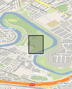
This summary borehole information release is for ‘as-built’ mine water and environmental baseline monitoring boreholes of the UK Geoenergy Observatories (UKGEOS) Glasgow facility at Cuningar Loop. The information pack from BGS contains a brief report with summary tables of locations, drilled depths, screened intervals and illustrative interpretations, and is accompanied with a spreadsheet and shapefile of the borehole locations and drilled depths. The purpose is to give potential users of the Glasgow Observatory an outline of the as-built infrastructure including condition of the target mine workings, as a summary of the more detailed information packs for each borehole. This dataset was updated in June 2020. Further details can be found in the accompanying report http://nora.nerc.ac.uk/id/eprint/526889
-

This dataset contains surface water and groundwater chemistry data of 111 samples - 41 surface waters, 63 groundwater, and 7 groundwater duplicates - collected at the UK Geoenergy Observatory (UKGEOS) in Glasgow, between 20 September 2022 and 12 January 2024 by the British Geological Survey (BGS), as part of the monitoring programme at the Glasgow research facility (https://www.ukgeos.ac.uk/glasgow-observatory). Samples are from 6 surface water sites, 5 mine water boreholes, and 5 environmental monitoring boreholes and were analysed at BGS and other laboratories. It includes the following parameters: field measurements of redox potential (ORP), pH, dissolved oxygen, electrical conductivity, alkalinity and water temperature, as well as chemical analyses of major, minor, and trace elements, non-purgeable organic carbon (NPOC), polycyclic aromatic hydrocarbons (PAH), total petroleum hydrocarbons (TPH), oxygen and deuterium isotopes (δ2H and δ18O), carbon isotopes in dissolved inorganic carbon (DIC) (δ13CDIC), and – limited to the groundwater samples – ammonium (NH4), reduced iron, dissolved sulphide, dissolved gases radon, methane, ethane and carbon dioxide (Rn, CH4, C2H6, CO2) and volatile organic compounds (VOC). The dataset consists of two excel files: GroundWaterChemData3 and SurfaceWaterChemData4, with an accompanying report by Palumbo-Roe et al. (2025).
-

The borehole information pack from borehole GGA02, site 01 of the UK Geoenergy Observatories (UKGEOS) Glasgow facility. This release from the British Geological Survey (BGS) contains BGS and Drillers’ logs, cased hole wireline data, details on fibre-optic cable installation, a listing of archived rock chips and a descriptive report. The borehole was drilled between 17th June and 20th September 2019 (start of drilling to casing installation date) to 94.16 m drilled depth as a mine water characterisation and monitoring borehole. Unfortunately, during the final stages of construction grout entered inside the casing, the casing was damaged and the borehole is now available as a sensor testing borehole to 67.2 m. The cased borehole was wireline logged in January 2020. Rock chip samples were taken during the drilling process and have been archived at the National Geological Repository at BGS Keyworth. Further details can be found in the accompanying report http://nora.nerc.ac.uk/id/eprint/528076 DOI https://dx.doi.org/10.5285/189dac62-b720-4fde-8260-f129fb9b0233
-

The borehole information pack from borehole GGA01, site 01 of the UK Geoenergy Observatories (UKGEOS) Glasgow facility. This release from the British Geological Survey (BGS) contains BGS and Drillers’ logs, cased hole wireline data, a listing of archived rock chips and a descriptive report. The mine water characterisation and monitoring borehole was drilled between 11th June and 21st August 2019 (start of drilling to casing installation date) to 52 m drilled depth. The cased borehole was wireline logged and hydrogeologically tested in January 2020. Rock chip samples were taken during the drilling process and have been archived at the National Geological Repository at BGS Keyworth. Further details can be found in the accompanying report http://nora.nerc.ac.uk/id/eprint/528075, DOI https://dx.doi.org/10.5285/0d496c68-f79b-4956-8cd2-4970d1e86145.
-
This dataset provides the first map and synthesis of the temperature of Britain's coalfields. It was created to support low-temperature heat recovery, cooling and storage schemes using mine water in abandoned workings. This baseline spatial mapping and synthesis of coalfield temperatures offers significant benefit to those planning, designing and regulating heat recovery and storage in Britain's abandoned coalfields. The dataset has been developed jointly by the Coal Authority and the British Geological Survey. It is delivered as a hexgrid representing mine water blocks, identifying equilibrium mine temperatures at 10 depth intervals (100 m > 1000 m) and pumped mine temperatures at 6 depth intervals (100 m > 600 m).