
Marine seismic surveys
Type of resources
Available actions
Topics
Keywords
Contact for the resource
Provided by
Years
Formats
Representation types
Update frequencies
Scale
-
The Marine Reports Archive held by BGS includes published and unpublished reports created by BGS and acquired from various sources. The reports which date from the 1960s onwards include the BGS Marine Reports Series, Marine Commercial reports and associated records, Palaeontology reports and other specialist reports. Examples of report types are data acquisition and processing reports, site investigation reports and interpretation reports. The reports are primarily for the UKCS (United Kingdom Continental Shelf). The coverage of some reports is the entire UKCS whilst other have only regional or very localised extent. The reports are applicable to a wide range of uses including environmental, geotechnical, geophysical and geological studies.
-
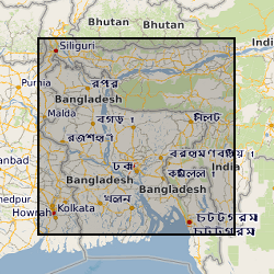
This dataset is an archive of the following original data for the seismic reflection surveys conducted by the BGS in Bangladesh for PetroBangla (Bangladesh state oil & gas company) and the UK Overseas Development Agency (funding body): Observers' logs, Surveyors' reports, Location data tapes, Field data recording tapes, Processed data tapes and various stages of processing: demultiplexed field data to migrated stack (not all available for all profiles). These data are kept as archive copies. They are only available with the agreement of PetroBangla and the ODA. Approx. written records and approx. 1200 tapes.
-

A set of seismic track data and accompanying interpretations in XGEO proprietary format. All of the data are project based and are commercially obtained. The interpretations and track data are confidential to the customer. Track data is digitised from maps and charts and combined with digitised seismic profile data interpreted by the geologist. Data are held by project and by user id. All project based datasets are complete but these data are not available to users except where explicit permission has been sought from the data supplier. Seismic track data is usually sampled at every 10th shotpoint. This represents a sampling interval of 250m. The seismic sections will have limits in two way time up to 10 seconds. Data is presented to UKOOA and SEQ standards in terms of data formats. There is a low level of consistency in reflector nomenclature inter-project but totally consistent intra-project.
-
This dataset represents a project-based collection of seismic interpretations of 2D and 3D commercial seismic reflection data. These data are integrated in a relational database in ORACLE in a data model called OpenWorks. Well log data, stratigraphic, velocity and well and seismic location data are also held in the database. Data interpretations are held within project indices by interpreter. Interpretations include faults and lithostratigraphic horizons. All data are commercial-in-confidence and cannot be supplied to any third party without the explicit permission of the customer or supplier.
-
This dataset comprises data from Wessex Archaeology surveys which were conducted over various wreck sites between 2003 and 2010. Three of these datasets were acquired in English waters, one in Welsh waters and one in Scottish waters. The geology and geophysics component of the data are archived by British Geological Survey (BGS) in the Marine Environmental data and Information Network (MEDIN) Data Archive Centre (DAC) for Geology and Geophysics. The data include multibeam echosounder, single-beam echosounder, sidescan sonar, sub-bottom profiler, magnetometer, and geological data (vibrocore logs and photos). Data were also provided to other archive centres as appropriate - UKHO (bathymetry), Royal Commission Ancient and Historic Monuments Wales (geophysics), Royal Commission on the Ancient and Historical Monuments of Scotland (geophysics and diving/ROV), Archaeology Data Service (diving/ROV). Although generated for archaeological purposes, these high quality and resolution data are capable of re-use by marine surveyors and scientists from a range of different fields. Data are delivered via the BGS Offshore GeoIndex www.bgs.ac.uk/GeoIndex/offshore.htm and additional data are available on request enquiries@bgs.ac.uk.
-
The British Geological Survey hold a collection of data recorded during marine geophysical surveys which includes digital data and analogue records. These data result from approximately 350,000 line kilometres of multi-instrument geophysical survey lines. The dataset includes seismic, sonar, magnetic, gravity, echo sounder, multibeam bathymetry and navigation data. The seismic data are mainly airgun, sparker, boomer and pinger data. Most of the data were collected by BGS, but the collection also includes some third party data. The data are primarily from the UKCS (United Kingdom Continental Shelf). The data are stored within the National Geoscience Data Centre (NGDC) as the Marine Environmental Data and Information Network (MEDIN) Data Archive Centre (DAC) for Geology and Geophysics. The majority of legacy geophysical paper records are available as scanned images. Other records can be scanned on request. Older records are of variable quality. Data not yet available online, including digital SEG-Y data, are available on request from enquiries@bgs.ac.uk. The data are applicable to a wide range of uses including environmental, geotechnical, geophysical and geological studies. For more information, refer to Fannin, N. G. T. (1989) Offshore Investigations 1966-87. British Geological Survey Technical Report WB/89/2, British Geological Survey.
-
BIRPS (the British Institutions Reflection Profiling Syndicate) acquired almost 650 km of offshore seismic data and 300 km of onshore seismic data over the Chicxulub impact crater. The data were recorded to 18 s two-way time.
-
WESTLINE was acquired by BIRPS (the British Institutions Reflection Profiling Syndicate). The seismic data image the faulted conjugate margins of the Rockall Trough and the intrabasinal sediments. The seismic data were shot to 18 s two-way time along a single 450 km-long transect.
-

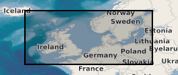
MONA LISA (Marine and Onshore North Sea Acquisition for Lithospheric Seismic Analysis) seismic data was acquired by BIRPS (the British Institutions Reflection Profiling Syndicate) across the Ringkobing-Fyn High of the central North Sea were designed to study the crust near a hypothesized Caledonian age triple junction associated with the colliding continental crust of Laurentia, Avalonia (Gondwanaland) and Baltica. The specific target was the eastward continuation of the Caledonian Front (Iapetus Suture), as previously recognised on NEC (North East Coast line), MOBIL (Measurements over Basins to Image Lithosphere), NSDP (North Sea Deep Profile) and BABEL (Baltic and Bothnian Echoes from the Lithosphere) profiles, in northern Europe. 1112 km of data were acquired, recorded to 26 s two-way time.
-
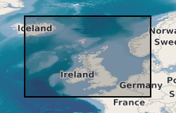
The British Institutions Reflection Profiling Syndicate (BIRPS) shot approximately 12,000 km of deep, multi-channel seismic reflection data around the British Isles from 1981 to 1991 during 14 surveys. Recording depths vary depending on the purpose of the survey but range from 15 s to 40 s two-way time. Raw and processed digital data are archived by BGS who make the data available subject to the cost of reproduction and handling. Seismic sections and other analogue ancillary data are available for some surveys. Gravity and magnetic data may also be available.