 NERC Data Catalogue Service
Jurassic
Type of resources
Available actions
Topics
Keywords
Contact for the resource
Provided by
Years
Formats
Representation types
Update frequencies
status
Scale
-

This document is the drillers log of strata encountered during site investigation work. The log was made in the field during drilling at Prees, Shropshire on 8th to 10th January 2020. The log includes basic information on lithology and drilling equipment used and depths of the individual core runs.
-
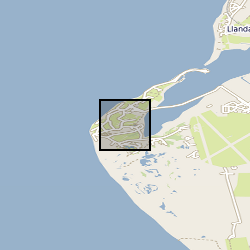
X-ray computed tomography (XCT) scans of four samples of consolidated shale from the Lower Jurassic (C.exaratum subzone) of the Cardigan Bay Basin (Wales, UK). The samples were taken from the Mochras Core, at depths of 789, 810, 812, and 818m (all samples within data measured in metres). Each sample is distinguished by its unique sample identification number (SSK). For each sample, there is a stack of XCT orthoslices (.tiff) files, and for SSK109633, an incomplete Avizo file. Mochras core location (aprox.) 52°48'39.74"N, 4° 8'48.09"W. Mochras Island, west of Llanbedr, Gwynedd, Wales, UK
-

3D laser surface scan of a fossil held within the BGS Type and Stratigraphical Reference Collection. Sample number: BGS GSM 37292 Species: Metrolytoceras metretum (Ammonite) Age: Inferior Oolite Group, Jurassic Location: near Sherborne, Dorset
-

Raw CT scan data for the following taxa (Euparkeria, Scelidosaurus, Lesothosaurus, Hypsilophodon, Herrerasaurus, Adeopapposaurus, Leyesaurus, Pantydraco, Heterodontosaurus, Coelphysis, Columba, Uromastyx), deposited as either .tif stacks or .dicom stacks, together with .vol files. CT reconstructions for each of these provided as .stls and in other file formats and also all files associated with the generation of Finite Element Models for each of these taxa. Reference photographs of specimens also provided where relevant. Scans and models are arranged in folders by taxon on a hard drive, accompanied by a Read Me file giving full details.
-

Raw and lithology-sorted data on building stone in about 125 churches in South Cambridgeshire. Each line on the sheets is one dated project of building or repair. The Key tab explains the various abbreviations on the sheet, and the nature of the data on each sheet. The data are the basis for a paper on "The choice of local or imported building stone in English medieval churches; a south Cambridgeshire case study" by N H Woodcock submitted to Geoheritage in June 2024"
-
This dataset shows the distribution of Middle Jurassic, Upper Jurassic and Lower Cretaceous lithostratigraphic (UK Offshore Operators Association - UKOOA) units within the UK North Sea graben. The data are based on a subset of released exploration and appraisal wells from within the UK North Sea graben areas. The well data are concentrated in the areas overlying the deep sedimentary basins of the Viking Graben, Central Graben and the Moray Firth Basin, with fewer wells over the adjacent platforms. The UKOOA lithostratigraphic classification has been applied consistently.
-

Clumped isotope analyses, raw data, replicates and temperatures calculated using the empirical calibration of Wacker et al. (2014), recalculated using the [Brand] isotopic parameters.
-
3D structured light surface scan of a fossil held within the BGS Type and Stratigraphical Reference Collection Sample number: BGS GSM 26215 Species: Lytoceras jurense (Ammonite) Age: Inferior Oolite Group, Jurassic Location: Quarry Hill, Chideock, Dorset
-

This dataset spans the Sinemurian-Pliensbachian boundary of the Llanbedr (Mochras Farm) drill core that was drilled onshore in the Cardigan Bay Basin, Wales, UK. This dataset contains 1. Micro-, macro-charcoal data and palynofacies, obtained at the University of Exeter (Streatham campus), UK, 2. Clay mineralogical data (X-ray diffraction (XRD)) obtained at the University of Burgundy, France, in collaboration with Jean-François Deconinck, 3. Carbon-isotope data, TOC and carbonate content, obtained at the University of Exeter (Penryn campus), UK. The dataset was created within the scope of the JET project (Integrated understanding of Early Jurassic Earth system and timescale) - https://gtr.ukri.org/projects?ref=NE%2FN018508%2F This project has received funding from the International Continental Scientific Drilling Programme (ICDP) and the UK Natural Environment Research Council (NERC). The PhD-project within this dataset was created is funded by the University of Exeter, UK.
-

**Nothing Known About This**Grain size analysis and statistics of Jurassic-Cretaceous and Tertiary sands from East Dorset, the Hampshire Basin and Shaftesbury area. Analysis taken from selected sites therefore not complete cover of the area.