 NERC Data Catalogue Service
Hydrocarbons
Type of resources
Available actions
Topics
Keywords
Contact for the resource
Provided by
Years
Formats
Representation types
Update frequencies
Scale
-

Surface sediment geochemistry data comprised of:1) trace metals; 2) Pb isotope ratios; 3) organic pollutants (pharmaceuticals, hydrocarbons and organochlorines and microtox bioassay). Sediments were collected from sites situated along Nairobi, Mathare and Ngong Rivers, Nairobi, Kenya on January 16th, 2020. This data is published in the following research paper which should be cited; Vane, C.H., Kim, A.W., Lopes dos Santos, R.A., Gill, J.C., Moss-Hayes, V., Mulu, J.K., Mackie, J.R., Ferreira, A.M.P.J., Chenery, S.R. and Olaka, L.A., 2022. Impact of organic pollutants from urban slum informal settlements on sustainable development goals and river sediment quality, Nairobi, Kenya, Africa. Applied Geochemistry, 146: 105468. https://doi.org/10.1016/j.apgeochem.2022.105468
-

Confidential data carried out for hydrocarbons etc.
-

to provide reliable molecular fingerprints for biodegraded crude oils and contaminated sediment cores and to facilitate correlation studies The aim is to demonstrate the potential of hydropyrolysis (pyrolysis assisted by high hydrogen gas pressure) as a novel means to provide reliable molecular fingerprints for biodegraded oils and contaminated cores where conventional biomarker approaches fail. This will then facilitate accurate and rapid oil-source and oil-oil correlations to be determined for the first time in these situations. New experimental protocols for conducting hydropyrolysis on asphaltenes will be developed. The study will establish a firm base to exploit the commercial potential of hydropyrolysis, both in oil exploration and for characterising sedimentary organic matter as a far superior technique to pyrolysis-GC-MS through a larger industrial partner.
-

PROJECT DETAILS ONLY - NO DATA. Sandstones in hydrocarbon basins are usually cemented by quartz: this frequently infills porosity by 50%, and so dramatically reduces reservoir quality. Predictive models for spatial patterns of cementation require to know the sources of silica, and the hydrogeology of cement-forming fluids. The ion microprobe has recently proved capable of in-situ micro analysis (0.02mm), to decipher the record of palaeo-fluids. To date 18O/16O has provided an effective tracer of fluid source, but sources of silica remain obscure. We will use the ion microprobe to investigate new geochemical tracers - B, Li, Al, 11B/10B (sigma11B), 30Si/28Si (sigma30Si) - to simultaneously discriminate silica sources, fluid sources, and fluid migration. This is a key step to more comprehensive predictive cementation models. Tracers will be tested in known hydrogeological settings, and by laboratory experiments.
-
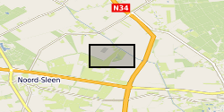
On December 1, 1965, an underground blowout during an exploratory drill with a catastrophic outcome occurred near Sleen, The Netherlands. During approximately 2.5 months, near-continuous leakage of large amounts of natural gas was released into the subsurface. After the blowout, the local drinking water production company installed a network of groundwater monitoring wells to monitor for possible adverse effects on groundwater quality at the blowout site. Today, more than 50 years after the blowout, the groundwater is still impaired. Data has been correlated with previously published data by Schout et al. (2018) covering description of geology and well depths. During October 2019 we sampled from 12 groundwater wells covering: - Inorganic parameters (hydrocarbons, anions, cations, DOC, alkalinity, nitrate and ammonium) - DNA (quantification of total bacteria by qPCR 16S, aerobic methane oxidation by qPCR pmoA, and anaerobic methane oxidation by qPCR mcrA) The dataset was created within SECURe project (Subsurface Evaluation of CCS and Unconventional Risks) - https://www.securegeoenergy.eu/. This project has received funding from the European Union’s Horizon 2020 research and innovation programme under grant agreement No 764531
-

PROJECT DETAILS ONLY - NO DATA. Mudstone microstructure is poorly understood even though it has a profound impact upon permeability. Mudstone permeability is critical in defining the rate at which oil and gas leak through oil and gas field caprocks, and the effectiveness of aquicludes utilised in protecting clean confined groundwater supplies and isolating wastes. During burial, mudstone permeability is controlled initially by the depositional fabric and mineralogy and then by mechanical compaction. A secondary stage of (chemical) compaction and permeability evolution will occur during progressive burial when diagenetic reactions, such as smectite-to-illite and clay-carbonate reactions, occur as a result of the faster reaction rates at higher temperatures and the overstepping of thermodynamic reaction boundaries. This research is intended to address the links between microstructure and mineralogy of mudstones, permeability, pore size distribution and their bulk sealing capacity. These data will be placed in the context of the geological history in terms of depth, temperature, pressure and effective stress histories.
-

The aim is to realise the potential of hydropyrolysis (pyrolysis assisted by high hydrogen gas pressures) as a means to provide reliable molecular fingerprints for severely biodegraded oils, contaminated cores, oil-field solids (tar mats and pyrobitumens) and to provide novel information on basin-filling history where the conventional free-biomarker approach fails. This will then facilitate rapid and accurate oil-source and oil-oil correlations to be determined for the first time in ocean-margin regions. The study will establish a firm base to exploit the commercial potential of hydropyrolysis, both in terms of oil exploration through the new correlations with bound biomarker profiles and of characteristic sedimentary organic matter as a far superior technique to py-GC-MS. Indeed, innovative experimental protocols for conducting hydropyrolysis will continue to be developed to have a prototype system ready for future exploitation.
-

Microfossil analyses carried out offshore for hydrocarbons etc. Commercial in Confidence.
-

The project will determine the distribution and magnitude of Tertiary hot fluid pulses throughout the North Atlantic region in order to advance significantly the modelling of thermal history and improve our understanding of fluid migration and reservoir cementation throughout the region. Two sampling transects extend (1) from west Greenland to the northern North Sea to assess variation with proximity to the Tertiary mantle plume, and (2) near-normal, from southernmost Greenland to offshore Norway. Using fluid inclusion and vitrinite reflectance data, heat flows will be modelled which are consistent with structures inferred from seismic sections. Anomalous heat flows will be combined with other data using a GIS framework.
-

This 'oilfield in a box' dataset contains all of the raw data available from the Hutton hydrocarbon field in the northern North Sea (quadrant 211), provided to BGS (British Geological Survey) through the National Hydrocarbon Data Archive. Petroleum licences issued by the Oil and Gas Authority (OGA) require that all hydrocarbon data from the UK continental shelf (UKCS) are preserved in perpetuity and in usable condition. Historically, a route to end this obligation was achieved by archiving data in the National Hydrocarbon Data Archive (NHDA), which was active from 2003 to 2016. The NHDA, operated by BGS on behalf of the UK Government, was the primary long-term data archive for UK offshore oil and gas exploration and production activity data. During its life the NHDA was used by various operators and organisations to archive a range of UKCS data from one field, 15 licences, 33 seismic surveys and 102 wells. Details on these can be found at the web link: http://www.bgs.ac.uk/nhda/home.html After decommissioning the Hutton Field, the (then) operator Kerr McGee deposited the well and seismic data within the NHDA. The NHDA has taken over management of these data and has now licensed it for academic and non-commercial use. This dataset represents a comprehensive record of the type of information collected over the lifetime of a hydrocarbon field, and comprises: borehole data from 65 wells across the Hutton Field, including wireline logs and reports; a 3D seismic survey; stratigraphic and production data.