
Gravity
Type of resources
Available actions
Topics
Keywords
Contact for the resource
Provided by
Years
Formats
Representation types
Update frequencies
status
Scale
Resolution
-
Long-range airborne geophysical measurements were carried out in the ICEGRAV campaigns (2010-2013), covering hitherto unexplored parts of interior East Antarctica and part of the Antarctic Peninsula. The airborne surveys provided a regional coverage of gravity, magnetic and ice-penetrating radar measurements for major Dronning Maud Land ice stream systems, from the grounding lines up to the Recovery Lakes drainage basin, and filled in major data voids in Antarctic data compilations.We present here the processed line aerogravity data collected using a LaCoste & Romberg air-sea gravity meter S83 mounted in the BAS aerogeophysically equipped Twin Otter aircraft. Data are provided as XYZ ASCII line data.
-
A British Antarctic Survey Twin Otter and survey team acquired 15,500 line-km of aerogeophysical data during the 2001/02 Antarctic field season along a 1-km line spacing grid with tie-lines 8 km apart. Twenty-five flights were flown from the South African base SANAE, for a total of 100 survey hours. We present here the processed line aerogravity data acquired using a LaCoste & Romberg air-sea gravity meter S83 mounted in the BAS aerogeophysically equipped Twin Otter aircraft. Data are provided as XYZ ASCII line data. This high-resolution aerogeophysical survey was part of the "Magmatism as a Monitor of Gondwanabreak-up" project (MAMOG) of the British Antarctic Survey, which included new geochemical investigations, structural geology, geochronology, and AMS studies over western Dronning Maud Land.
-
During the 2001-02 field season a regional survey was flown on a 10 km line spacing grid over the drainage basin of the Rutford Ice stream (West Antarctica), as part of the TORUS (Targeting ice stream onset regions and under-ice systems) project. We present here the processed line aerogravity data collected using a LaCoste & Romberg air-sea gravity meter S83 mounted in the BAS aerogeophysically equipped Twin Otter aircraft. Data are provided as XYZ ASCII line data.
-
During the austral summer of 2004/05 a collaborative US/UK field campaign undertook a systematic geophysical survey of the entire Amundsen Sea embayment using comparable airborne survey systems mounted in Twin Otter aircraft. Here we present the portion of the survey covering the Pine Island Glacier basin led by British Antarctic Survey. Operating from a temporary field camp (PNE, S 77deg34' W 095deg56'; we collected ~35,000 km of airborne survey data. Our aircraft was equipped with dual-frequency carrier-phase GPS for navigation, radar altimeter for surface mapping, wing-tip magnetometers, gravity meter, and a new ice-sounding radar system (PASIN). We present here the processed line aerogravity data collected using a LaCoste & Romberg air-sea gravity meter S83 mounted in the BAS aerogeophysically equiped Twin Otter aircraft. Data are provided as XYZ ASCII line data.
-
During the 2010/2011 Antarctic field season a collaborative NERC AFI (Antarctic Funding Initiative) project studying the basal boundary conditions of the Institute & Moller ice streams, West Antarctica, collected ~25,000 km of new high quality aerogravity data. Data were acquired using Lacoste and Romberg air-sea gravity meter S83, mounted in the BAS aerogeophysically equipped Twin Otter "Bravo Lima". Data are provided as XYZ ASCII line data. Data were collected as part of the UK Natural Environment Research Council AFI grant NE/G013071/1.
-
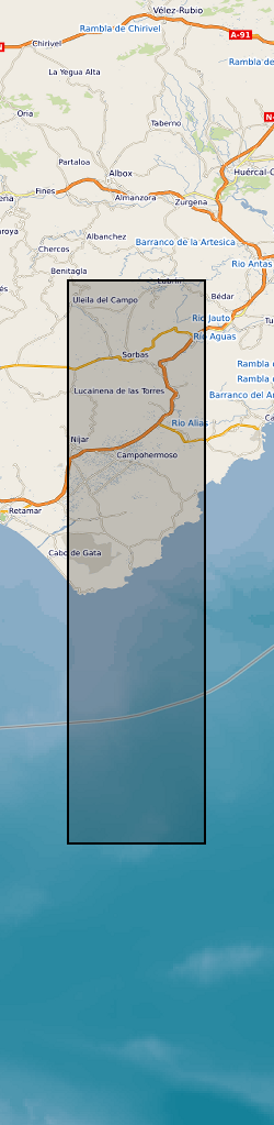
The dataset comprises: Petrophysical data for rocks from the region, XRD mineralogical data, Results of the gravity survey of the basin, tabulation and location of all bedding orientation data for the basin, and sediment transport lineation data. The dataset accompanies publication : On the Structure and Evolution of the Sorbas Basin, S.E. Spain, Tectonophysics 773 (2019) 228230, DOI: https://doi.org/10.1016/j.tecto.2019.228230
-
Microgravity data collected at Uturuncu Volcano between March 2010 and November 2018 The file contains microgravity data collected between March 2010 and November 2018 in the Altiplano-Puna Volcanic complex.
-
The data set contains location (latitude and longitude), ellipsoidal height (m) and observed gravity of benchmarks at the Campi Flegrei caldera, Italy. The gravity and location data were collected between 8 and 12 July, 2015 using a Scintrex CG5 gravimeter (serial number: 572) in tandem with a TOPCON HiPer Pro Dual-Frequency GNSS base and rover system. The survey contained a total of 85 benchmarks in addition to the base station.
-
Report: Brett, CP. 1984. Operations Report on Projects 84/02 and 84/03 Regional Geophysical Surveys in the Southern North Sea, and Project 84/04, a Short Gravity Survey in Norwegian Waters. (IGS Report No 151). The primary objective was to survey aines in Belgian and Dutch waters.
-
Report: Deegan, SE. 1976. Cruise Report on Project 76/01. SW Approaches and English Channel. (IGS Report No 83) Navigation: Magnavox integrated satellite navigation/doppler sonar system, back-up control was from the Decca Navigator Mk 12. Equipment: Atlas Deso 10 and Edig 10 echo sounder, Askania GSS-3 gravity meter, Edo Pinger, EG&G 9 candle spark array, Klein Dual Scan Sonar System and BP Sonar System. No information on magnetometer. The first objective was to survey seven proposed borehole sites with sparker and pinger. These sites were to the north-west of Scilly. During leg 2 it became necessary to survey additional sites to the south-west of the Lizard. The second objective was a regional marine geophysical survey of the 1:250000 Scilly sheet, which would include the use of gravity meter, magnetometer, sparker, pinger and sonar.