
Arsenic
Type of resources
Available actions
Topics
Keywords
Contact for the resource
Provided by
Years
Formats
Representation types
Update frequencies
Scale
-
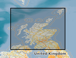
THIS DATASET HAS BEEN WITHDRAWN **This dataset was created for the "Britain beneath our feet" atlas using information extracted from the Geochemical Baseline Survey Of The Environment (G-BASE) For The UK . For Arsenic in soil data please see Geochemical Baseline Survey Of The Environment (G-BASE) For The UK ** Geochemical Baseline Survey Of The Environment (G-BASE) coverage for arsenic in soil. The G-BASE programme involves systematic sampling and the determination of chemical elements in samples of stream sediment, stream water and, locally, soil, to build up a picture of the surface chemistry of the UK. The average sample density for stream sediments and water is about one site per 1.5-2km square. Analytical precision is high with strict quality control to ensure countrywide consistency. Results have been standardised to ensure seamless joins between geochemical sampling campaigns. The data provide baseline information on the natural abundances of elements, against which anomalous values due to such factors as mineralisation and industrial contamination may be compared. Published in Britain beneath our feet atlas.
-
This dataset represents the raw reads from sequencing the V4 hyper-variable region of the 16S rRNA gene on an Illumina MiSeq platform. The samples are filtered groundwater samples from 8 boreholes from a sandy-dominated site and a clay-dominated site in Cambodia that show arsenic concentrations above the WHO recommended limit, and were collected in May 2019.
-
The Estimated Ambient Background Soil Chemistry England and Wales dataset indicates the estimated geometric mean topsoil Arsenic(As), Cadmium (Cd), Cr (Chromium), Nickel (Ni) and Lead (Pb) concentrations (mg kg-1). The soil chemistry data is based on GBASE (Geochemical Baseline Survey of the Environment) soil geochemical data where these are available. Elsewhere the stream sediment data are converted to surface soil equivalent potentially harmful element (PHE) concentrations. This dataset covers England and Wales but data is available for the whole of Great Britain, with the exception of the London area where an inadequate number of geochemical samples are available at the moment.
-

This dataset has now been superseded, please see the Measured Urban Soil Chemistry dataset. The BGS digital point source urban soil chemistry data (GB_PointSourceUrbanSoilPHE_v1) comprises the locations and concentrations (mg kg-1) of Arsenic (As), Cadmium (Cd), Chromium (Cr), Nickel (Ni) and Lead (Pb) in urban topsoil samples. The data is derived from the national, high resolution urban soil geochemical data from the BGS Geochemical Baseline Survey of the Environment (G-BASE) project. The information is relevant for the first stage of any assessment of risks to human health required by regulatory authorities in relation to land use and also for assessing ecological risk. Although point source PHE (Potentially Harmful Element) concentrations above respective SGVs (Soil Guideline Value) do not necessarily imply a significant health risk, they do highlight the need to consider whether or not there may be a risk. The urban soil chemistry data can be used to assist Local Planning Authorities to identify those areas where a risk assessment may need to be carried out by developers. Comparison of this spatially referenced geochemical data with information on current or historic land use and geological information might help environmental professionals decide whether high PHE concentrations in topsoils can be attributed to geogenic or anthropogenic sources. The point source data is based on an interpretation of the records in the possession of the BGS at the time the dataset was created.
-

This dataset has now been superseded, please see the Estimated Urban Soil Chemistry dataset. There are two themes to BGS urban soil chemistry, the point source dataset and the estimated dataset. The point source urban soil chemistry data comprises the locations and concentrations (mg kg-1) of Arsenic (As). Cadmium (Cd), Chromium (Cr), Nickel (Ni) and Lead (Pb) in urban topsoil samples. The Estimated Urban Soil Chemistry data indicates the estimated geometric mean concentrations (mg kg-1) of As, Cd, Cr, Ni and Pb in topsoil derived by spatial interpolation of the Point Source Urban Soil Chemistry data. Both urban soil chemistry datasets are derived from high resolution urban soil geochemical data from the BGS Geochemical Baseline Survey of the Environment (G-BASE) project. The Urban Soil Chemistry data can be used to assist Local Planning Authorities to identify those areas where a risk assessment may need to be carried out by developers. Comparison of this spatially referenced geochemical data with information on current or historic land use and geological information might help environmental professionals decide whether high PHE concentrations in topsoils can be attributed to geogenic or anthropogenic sources. The dataset is based on, and limited to, an interpretation of the records in the possession of the BGS at the time the dataset was created.
-

The BGS Estimated Ambient Background Soil Chemistry Scotland digital soil chemistry data indicates the estimated geometric mean topsoil concentrations (mg kg-1) of Arsenic (As), Cadmium (Cd), Chromium (Cr), Nickel (Ni) and Lead (Pb). The soil chemistry data is based on GBASE (Geochemical Baseline Survey of the Environment) stream sediment data converted to top soil equivalent potentially harmful element(PHE) concentrations. This dataset covers Scotland but data is available for the whole of Great Britain, with the exception of the London area where an inadequate number of geochemical samples are available at the moment.
-

This dataset has now been superseded, please see the Estimated Ambient Background Soil Chemistry England and Wales dataset. This dataset indicates the estimated topsoil Arsenic(As), Cadmium (Cd), Cr (Chromium), Nickel (Ni) and Lead (Pb) concentrations (mg kg-1) derived by spatial interpolation of the point source urban soil PHE (potentially harmful elements) data. Urban soil geochemical data generally have large positive skewness coefficients so were transformed by taking natural logarithms. To overcome the bias associated with traditional measures of location (mean) and scale (standard deviation) for log-normal data, the inverse distance weighted (IDW) mean and standard deviation of log transformed element concentrations were used for mapping the spatial variation in As, Cd, Cr, Ni and Pb concentrations. The soil chemistry data is based on GBASE (Geochemical Baseline Survey of the Environment) soil geochemical data where these are available. Elsewhere the stream sediment data are converted to surface soil equivalent potentially harmful element(PHE) concentrations. This dataset covers England and Wales but data is available for the whole of Great Britain, with the exception of the London area where an inadequate number of geochemical samples are available at the moment.
-

These are groundwater geochemical data taken from two sites in the Kien Svay district of northern Kandal Province, Cambodia, southeast of Phnom Penh. These sites are referred to as “clay-dominated” and “sand-dominated” in reference to the known lithology and are known for high arsenic concentrations (Richards et al., 2017). Each site contained four 18 m boreholes installed in January 2019 using manual drilling described in Richards et al (2015), spaced evenly about ~1.5 m apart. The boreholes that were located at the clay-dominated site are referred to NB01, NB02, NB03 and NB04. The boreholes that were located at the sand-dominated site are referred to as NB05, NB06, NB07 and NB08. Two sampling campaigns were carried out: 6th-12th May 2019 (pre-monsoon season), and 27th-31st January 2020 (post-monsoon season). References: Richards, L. A., Magnone, D., Sovann, C., Kong, C., Uhlemann, S., Kuras, O., van Dongen, B. E., Ballentine, C. J., Polya, D. A. High Resolution Profile of Inorganic Aqueous Geochemistry and Key Redox Zones in an Arsenic Bearing Aquifer in Cambodia. Science of The Total Environment 2017, 590–591, 540–553. Richards, L. A., Magnone, D., van Dongen, B. E., Ballentine, C. J., Polya, D. A. Use of Lithium Tracers to Quantify Drilling Fluid Contamination for Groundwater Monitoring in Southeast Asia. Applied Geochemistry 2015, 63, 190–202.
-
The BGS digital Measured Urban Soil Chemistry data comprises the locations and concentrations (mg kg-1) of Arsenic (As), Cadmium (Cd), Chromium (Cr), Nickel (Ni) and Lead (Pb) in urban topsoil samples. The data is derived from the national, high resolution urban soil geochemical data from the BGS Geochemical Baseline Survey of the Environment (G-BASE) project. The information is relevant for the first stage of any assessment of risks to human health required by regulatory authorities in relation to land use and also for assessing ecological risk. Although point source PHE (Potentially Harmful Element) concentrations above respective SGVs (Soil Guideline Value) do not necessarily imply a significant health risk, they do highlight the need to consider whether or not there may be a risk. The urban soil chemistry data can be used to assist Local Planning Authorities to identify those areas where a risk assessment may need to be carried out by developers. Comparison of this spatially referenced geochemical data with information on current or historic land use and geological information might help environmental professionals decide whether high PHE concentrations in topsoils can be attributed to geogenic or anthropogenic sources. The point source data is based on an interpretation of the records in the possession of the BGS at the time the dataset was created.
-
This dataset has now been superseded, please see the Estimated Ambient Background Soil Chemistry Scotland dataset. The BGS digital soil chemistry data indicates the estimated geometric mean concentrations (mg kg-1) of Arsenic (As), Cadmium (Cd), Chromium (Cr), Nickel (Ni) and Lead (Pb) in surface soil. The soil chemistry data is based on GBASE (Geochemical Baseline Survey of the Environment) soil geochemical data where these are available. Elsewhere the stream sediment data are converted to surface soil equivalent potentially harmful element(PHE) concentrations. This dataset covers Scotland but data is available for the whole of Great Britain, with the exception of the London area where an inadequate number of geochemical samples are available at the moment.