
1995
Type of resources
Available actions
Topics
Keywords
Contact for the resource
Provided by
Years
Formats
Representation types
Update frequencies
Service types
Scale
-

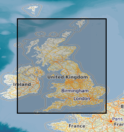
This service is a BGS contribution to the OneGeology project, providing UK onshore geological data at 1:625 000 scale. This map data is collected as part of an ongoing BGS project: Digital Geological Map of Great Britain (DiGMapGB). MapServer software is used to provide this view services. This service is one of the exemplar services accompanying the OneGeology cookbook
-

Data related to contaminated land projects completed under commercial contract for local authorities (ConSEPT). The data held and used in the project included published BGS data (borehole, BGS Geology 50k and 10k, water well information), as well as third party data held on behalf of local authorities (including current and historical land use polygons and landfill sites) for the purposes of building the ConSEPT GIS. Consequently some data and the projects are strictly commercial in confidence and should not be shared.
-

Spatial data for Bishket urban pollution project data on groundwater pollution
-

Data on borehole/wellstats and design summaries for Bishket, Kyrghystan.
-

The 1:50 000 scale GeoSure (natural ground stability) data covering the map sheets for Loughborough and Kilmarnock are available in this OGC WFS service for personal, non-commercial use only. This service is a contribution to the OneGeology-Europe initiative. For information about more of the British Geological Survey's maps and other digital products please visit https://www.bgs.ac.uk/geological-data/. MapServer software is used to provide this OGC WFS service.
-

Data from the DiGMap covering the whole of the United Kingdom at a scale of 1:625 000 is available in this OGC WMS service for personal, non-commercial use only. The service is a contribution to the OneGeology-Europe initiative. The layers can be displayed either by age or by lithology. For more information about the digital maps available from the British Geological Survey, please visit https://www.bgs.ac.uk/datasets/bgs-geology/
-

These services are a BGS contribution to the OneGeology project, providing UK onshore geological data at 1:625 000 scale and UK continental shelf seabed sediment data at 1:1 million scale. This map data is collected as part of an ongoing BGS project: Digital Geological Map of Great Britain (DiGMapGB). MapServer software is used to provide these OGC download APIs.
-

This service is a BGS contribution to the OneGeology project, providing UK onshore geological data at 1:625 000 scale. This map data is collected as part of an ongoing BGS project: Digital Geological Map of Great Britain (DiGMapGB). MapServer software is used to provide this view services.
-
BGS have collected environmental radioactivity data for various purposes over several decades. This is being drawn together to produce a database of baseline gamma radioactivity and radon. Data includes the relevant portions of airborne and ground gamma spectrometer surveys, mineral exploration, baseline geochemistry and environmental radiometric surveys along with lithogeochemical and borehole log data. It is predominantly a specialist subset of other existing BGS databases. Incomplete UK coverage.
-
This service is a BGS contribution to the OneGeology project, providing UK onshore geological data at 1:625 000 scale and UK continental shelf seabed sediment data at 1:1 million scale. This map data is collected as part of an ongoing BGS project: Digital Geological Map of Great Britain (DiGMapGB). MapServer software is used to provide this view services.