1992
Type of resources
Topics
Keywords
Contact for the resource
Provided by
Years
Formats
Representation types
Update frequencies
Scale
-
The European Arctic Stratospheric Ozone Experiment (EASOE) was undertaken in the northern winter of 1991-92 to study the processes in the Arctic which lead to ozone destruction and their connection with reduced ozone at northern mid-latitudes. The data from the campaign has been made available on CD-ROM by the Norwegian Institute for Air Research (NILU). The CDs are held at the BADC. This two CD-ROM set contains measurements made from 16 ground stations throughout Europe, flights made by the three aircraft involved in the campaign, numerous stratospheric balloons launched from Kiruna in northern Sweden and from ozonesondes from 28 European stations. In addition data from the total ozone monitoring network are included. The parameters measured include concentrations of ozone and the members of the chlorine and nitrogen families which are involved in the photochemical destruction of ozone, aerosol and PSC extinctions and meteorological parameters used to study transport into and out of the polar vortex. The EASOE campaign coincided with the NASA AASE-II aircraft campaign and this dataset is also available from the BADC.
-

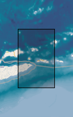
In 1992, BIRPS joined with the Indonesian Marine Geological Institute to record two long multichannel normal-incidence reflection profiles, one of which is DAMAR, the other TIMOR, and one short profile (API) close to the volcano Gunung Api. The survey provides a modern analogue to tectonics hypothesized to have occurred across the Iapetus suture zone of northern England 450-400 Ma. The Banda Arc of Indonesia near the island of Timor is widely recognized as the premier example of the active subduction of continental crust and lithosphere beneath oceanic lithosphere. The crossing of a modern island arc and close passage to active volcanoes was intended to image reflections associated with magma in the crust and uppermost mantle.
-
The objective of the Greenhouse Effect Detection Experiment (GEDEX) was to assemble and document existing data for the analysis of global climate change and to distribute these data to promote further research.Data from GEDEX comprises of a collection of 60+ global climate change datasets assembled on a NASA CD-ROM. Data include surface, upper air and satellite measurements of temperature, solar irradiance, clouds, greenhouse gases, fluxes, albedos, ozone and water vapour plus Southern Oscillation indices and QBO statistics. Specific datasets include the Earth Radiation Budget Experiment (ERBE), the Advanced Very High Resolution Radiometer (AVHRR), the Stratospheric Aerosol and Gas Experiment (SAGE I and II), the TIROS Operational Vertical Sounder (TOVS), Visible Infrared Spin Scan Radiometer (VISSR) and the International Satellite Cloud Climatology Project (ISCCP). Resolution and timespan varies with dataset. This dataset is public.
-

Database initiated as part of NERC Land-Ocean Interaction Study. Will be linked to SOBI when project ends in March 2000.
-
The Airborne Arctic Stratospheric Expedition II (AASE II) which was based in Bangor, Maine between October 1991 and March 1992, with ER-2 flights from Ames Research Center, Fairbanks (Alaska), and Bangor; and DC-8 flights from Ames, Bangor, Anchorage (Alaska), Stavanger (Norway), and Tahiti, was a follow-up to an earlier AASE campaign in 1989. The dataset consists of measurements collected onboard the NASA ER-2 and DC-8 aircraft (for example, ClO, BrO, HCl, O3, NOx, N2O, HNO3, whole air samples and aerosol measurements). In addition, there are ozonesonde soundings from six Canadian stations, global grid point values of Nimbus 7 TOMS ozone, and selected radiosonde soundings from stations in the region of the experiment. Theory teams provided calculations of potential vorticity, temperature, geopotential, horizontal winds, parcel back trajectories, and concentrations of short lived species along the aircraft flight tracks; and northern hemispheric analyses of potential vorticity, temperature, geopotential, horizontal winds, and radiative heating rates.
-

This dataset is an taxonomic listing (various phyla and families) of Quaternary, Upper Tertiary and Carboniferous fossils relevant to the palaeontology of Scotland and Northern England. Species authors and some dates are given. The MS Access database MTD_TAXALIST presently contains 1169 records. It has provision for environmental interpretation, and publications in which the fossils are illustrated.
-
This dataset contains existing and potential areas of habitats associated with calcareous, coastal, upland and lowland heath landscapes. The dataset was initially created to provide a sampling framework for a field survey carried out in 1992 and 1993 by the Institute of Terrestrial Ecology (later part of the Centre for Ecology & Hydrology). It was derived from a range of geology, soils, altitude and land cover data (as described fully in the supporting information). Full details about this dataset can be found at https://doi.org/10.5285/dc583be3-3649-4df6-b67e-b0f40b4ec895
-
The dataset comprises 102 hydrographic data profiles, collected by a conductivity-temperature-depth (CTD) sensor package, from across the North Sea area specifically the east coast of Scotland, during April of 1992. A complete list of all data parameters are described by the SeaDataNet Parameter Discovery Vocabulary (PDV) keywords assigned in this metadata record. The data were collected by the Scottish Office Agriculture and Fisheries Department Aberdeen Marine Laboratory.
-
This dataset comprises hydrographic data profiles, collected by a conductivity-temperature-depth (CTD) sensor package, during March 1992. It incorporates tidal cycle CTD anchor stations off Whitehaven and on a dump site in Liverpool Bay. The data were collected by the Ministry of Agriculture, Fisheries and Food Lowestoft Fisheries Laboratory.
-
This dataset comprises 84 hydrographic data profiles, collected by a conductivity-temperature-depth (CTD) sensor package, in September 1989 from stations covering the southern North Sea (south of 56N). A complete list of all data parameters are described by the SeaDataNet Parameter Discovery Vocabulary (PDV) keywords assigned in this metadata record. The data were collected by the Plymouth Marine Laboratory as part of the North Sea Project Resuspension Process Study.
 NERC Data Catalogue Service