 NERC Data Catalogue Service
Airborne geophysical data from the Tellus South West project
Simple
- Date (Creation)
- 2014
0115 936 3276
0115 936 3276
0115 936 3276
0115 936 3276
- Maintenance and update frequency
- notPlanned Not planned
- GEMET - INSPIRE themes, version 1.0
- BGS Thesaurus of Geosciences
-
- Aerial surveys
- Geophysics
- Magnetic surveys
- Geophysical surveys
- dataCentre
- Keywords
-
- NERC_DDC
- Access constraints
- otherRestrictions Other restrictions
- Use constraints
- otherRestrictions Other restrictions
- Other constraints
- The copyright of materials derived from the British Geological Survey's work is vested in the Natural Environment Research Council [NERC]. No part of this work may be reproduced or transmitted in any form or by any means, or stored in a retrieval system of any nature, without the prior permission of the copyright holder, via the BGS Intellectual Property Rights Manager. Use by customers of information provided by the BGS, is at the customer's own risk. In view of the disparate sources of information at BGS's disposal, including such material donated to BGS, that BGS accepts in good faith as being accurate, the Natural Environment Research Council (NERC) gives no warranty, expressed or implied, as to the quality or accuracy of the information supplied, or to the information's suitability for any use. NERC/BGS accepts no liability whatever in respect of loss, damage, injury or other occurence however caused.
- Other constraints
- There are no restrictions on the use that may be made of the dataset, although an appropriate copyright acknowledgement must be made when any part of the dataset is reproduced. Either no third party data / information is contained in the dataset or BGS has secured written permission from the owner of any third party data / information contained in the dataset to make the dataset freely available without any use constraints - inclusion of any third party data / information will affect the copyright acknowledgement that needs to be made.
- Spatial representation type
- grid Grid
- Metadata language
- EnglishEnglish
- Topic category
-
- Geoscientific information
- Geographic identifier
-
Cornwall County [id=24167]
- Date (Revision)
- 2009
- Geographic identifier
-
Devon County [id=23147]
- Date (Revision)
- 2009
- Geographic identifier
-
Somerset County [id=10578]
- Date (Revision)
- 2009
))
- Begin date
- 2013-08
- End date
- 2014-01
- Supplemental Information
- Further information can be found at the project website http://www.tellusgb.ac.uk/
- Unique resource identifier
- OSGB 1936 / British National Grid (EPSG::27700)
- Distribution format
-
-
ASCII (.csv)
(
witheld
)
-
Image (GeoTIFF)
()
-
ASCII (.csv)
(
witheld
)
0115 936 3276
0115 936 3276
- OnLine resource
-
Citation Information - Digital Object Identifier (DOI)
(
WWW:LINK-1.0-http--related
)
When using the DOI in subsequent publications please include the author(s) and date within the text and the full DOI citation in the references section e.g. '(Beamish et al. 2014)' in the text and 'Beamish, D., Howard, A., Ward, E.K., White, J., Young, M. E. (2014) Tellus South West airborne geophysical data. NERC-Environmental Information Data Centre. Doi: 10.5285/73848363-57c1-480a-a64e-c732e15c4b37' in the references section.
- OnLine resource
- Data ( WWW:LINK-1.0-http--link )
- Hierarchy level
- dataset Dataset
- Other
- dataset
Conformance result
- Date (Publication)
- 2011
- Explanation
- See the referenced specification
- Pass
- No
Conformance result
- Date (Publication)
- 2010-12-08
- Explanation
- See http://eur-lex.europa.eu/LexUriServ/LexUriServ.do?uri=OJ:L:2010:323:0011:0102:EN:PDF
- Pass
- No
- Statement
- The lineage is reported in a BGS technical report: http://nora.nerc.ac.uk/506870/
- File identifier
- faeaeb7a-af7d-4159-e044-002128a47908 XML
- Metadata language
- EnglishEnglish
- Hierarchy level
- dataset Dataset
- Date stamp
- 2026-05-06
- Metadata standard name
- UK GEMINI
- Metadata standard version
- 2.3
- Dataset URI
- http://data.bgs.ac.uk/id/dataHolding/13606207
Overviews
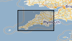
Spatial extent
Provided by
