 NERC Data Catalogue Service
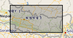
Simplified Geological Map of central-eastern Nepal (NERC Grant NE/L002582/1)
Raster (TIFF) file showing the simplified main bedrock geology units that comprise a ~45,000 km2 region of central-eastern Nepal.
Simple
- Date (Creation)
- 2021-05-12
Originator
University of Plymouth
-
Joshua Jones
(
School of Geography, Earth and Environmental Sciences
)
Plymouth
,
Principal investigator
University of East Anglia
-
Professor WT Sturges
(
School of Environmental Sciences
)
Norwich Research Park
,
Norwich
,
NR4 7TJ
,
- Maintenance and update frequency
- notApplicable notApplicable
- GEMET - INSPIRE themes, version 1.0
- BGS Thesaurus of Geosciences
-
- Geology
- Geological maps
- Maps
- NGDC Deposited Data
- dataCentre
- Keywords
-
- NERC_DDC
- Access constraints
- otherRestrictions Other restrictions
- Other constraints
- licenceOGL
- Use constraints
- otherRestrictions Other restrictions
- Other constraints
- The copyright of materials derived from the British Geological Survey's work is vested in the Natural Environment Research Council [NERC]. No part of this work may be reproduced or transmitted in any form or by any means, or stored in a retrieval system of any nature, without the prior permission of the copyright holder, via the BGS Intellectual Property Rights Manager. Use by customers of information provided by the BGS, is at the customer's own risk. In view of the disparate sources of information at BGS's disposal, including such material donated to BGS, that BGS accepts in good faith as being accurate, the Natural Environment Research Council (NERC) gives no warranty, expressed or implied, as to the quality or accuracy of the information supplied, or to the information's suitability for any use. NERC/BGS accepts no liability whatever in respect of loss, damage, injury or other occurence however caused.
- Other constraints
- Available under the Open Government Licence subject to the following acknowledgement accompanying the reproduced NERC materials "Contains NERC materials ©NERC [year]"
- Spatial representation type
- textTable Text, table
- Metadata language
- EnglishEnglish
- Topic category
-
- Geoscientific information
- Geographic identifier
-
NEPAL [id=497000]
- Date (Creation)
- 1979
- Geographic identifier
-
NP
- Date (Revision)
- 2009
- Geographic identifier
-
NPL
- Date (Revision)
- 2009
N
S
E
W
))
- Begin date
- 2018-05-01
- End date
- 2018-05-31
- Unique resource identifier
- WGS 84 (EPSG::4326)
- Distribution format
-
-
Image (TIFF)
()
-
Image (TIFF)
()
- OnLine resource
- Data ( WWW:DOWNLOAD-1.0-http--download )
- Hierarchy level
- dataset Dataset
- Other
- dataset
Conformance result
- Date (Publication)
- 2011
- Explanation
- See the referenced specification
- Pass
- No
Conformance result
- Date (Publication)
- 2010-12-08
- Explanation
- See http://eur-lex.europa.eu/LexUriServ/LexUriServ.do?uri=OJ:L:2010:323:0011:0102:EN:PDF
- Pass
- No
- Statement
- This map was digitised, simplified and modified using standard GIS approaches from several 1:250,000 Geological Maps of Nepal provided by the Nepal Department of Geology and Mines. These data have been significantly simplified from the originals.
- File identifier
- c29d1544-289e-30ca-e054-002128a47908 XML
- Metadata language
- EnglishEnglish
- Hierarchy level
- dataset Dataset
- Date stamp
- 2025-12-11
- Metadata standard name
- UK GEMINI
- Metadata standard version
- 2.3
Point of contact
British Geological Survey
Environmental Science Centre,Keyworth
,
NOTTINGHAM
,
NOTTINGHAMSHIRE
,
NG12 5GG
,
United Kingdom
+44 115 936 3100
- Dataset URI
- http://data.bgs.ac.uk/id/dataHolding/13607752
Overviews
Spatial extent
N
S
E
W
Provided by

Associated resources
Not available